Items Similar to Bermuda: An Early 17th Century Hand-colored Map by Henricus Hondius

Want more images or videos?
Request additional images or videos from the seller
1 of 9
Henricus Hondius Bermuda: An Early 17th Century Hand-colored Map by Henricus Hondius1633
1633
About the Item
This attractive and interesting map of Bermuda by Henricus Hondius in 1633 is entitled "Mappa Aestivarum Insularum, Alias Barmudas". It is based on a survey of Richard Norwood in 1618, which led to earlier maps by John Speed in 1627. Henricus's older brother, Jodocus Hondius II, engraved a version of the map for the family firm, but had sold the copper plates of several maps to Willem Blaeu, who used them as the core of his new atlas in 1630, forcing Henricus to engrave another. version A later state has Hondius's name removed and replaced with that of Johannes Jansson.
There is a central vertical fold, as issued. There is a short tear at the lower edge.
Henricus Hondius' 1633 map of Bermuda, entitled "Mappa Aestivarum Insularum, Alias Barmudas," is a beautiful and historically significant map that depicts the islands of Bermuda. The map is oriented with north to the right, which was a common orientation for maps of this time period. Overall, Henricus Hondius' 1633 map of Bermuda is a stunning example of cartography from the seventeenth century. Its detailed depiction of the islands of Bermuda and its illustrations of ships and sea creatures make it a fascinating historical artifact.
Bermuda was discovered by the Spaniard Juan de Bermudez in 1515, and is named for him. The first settlers of Bermuda resulted from an expedition of Virginia colonists led by Sir George Somers in 1609. His ship, the ‘Sea Venture’ was wrecked off the coast of Bermuda in 1609. The surviving Englishmen divided the island into Tribes and lots (later Parishes). The Latin title of this map, "Aestivarum Insularum" means summers (or Somers) Islands. The experience of Somers and his men inspired William Shakespeare, who dispatched Ariel to "fetch dew from the still-vext Bermoothes" and populated the islands with the cast of The Tempest. The Bermudas were granted to the Virginia Company, which is referenced on the map. The distance to the company's headquarters in Roanoke Colony in Virginia is shown on the map. In 1610, the Virginia Company, in a True Declaration of the Estate of the Colonie of Virginia, said of Bermuda: "These Islands of Bermudos, have evere beene accounted as an inchaunted pile of rocks, and a desert inhabitation for Divels; but all the Faities of the rockes were but flocks of Birds, and all the Divels that haunted the woods, were but heards of Swine".
Bermuda is superimposed over a map of the Atlantic with the coastlines of Britain, North America and Hispaniola to demonstrate the relative location of the island. The miniature map below the carouche in the upper left with its own scale, shows the island’s position relative to Cape Cod, Nova Scotia and the Virginian coast. The map vividly illustrates how hazardous the coastline of Bermuda was and still is to shipping by the almost unbroken ring of crosses signifying wrecks surrounding the island. The map is embellished with a striking decorative cartouche centrally, a beautiful compass rose, numerous rhumb lines, a coat-of-arms in the lower left and a vignette in the lower right presumably depicting the wreck of the 'Sea Venture'. The table at the bottom includes a list of the original English "proprietors" the location of the "Tribes" and lots and the number of shares purchased by each proprietor, along with a number key, identifying the land owned by each of the shareholders. French text is present on the verso. There is a beautiful compass rose in the upper right, as well as two other compass roses, with multiple rhumb lines. A vignette in the lower left corner contains a coat-of-arms and another in the lower right corner contains an image of a ship running aground against a large rock formation, representing the shipwreck in 1609 leading to the Virginia colonists populating the island.
This striking and historically significant map of Bermuda is printed on laid chain-linked paper with wide margins. The sheet measures 19" high and 22.38" wide. It has a vertical center fold, as issued. There is mild irregularity of the lower edge and three short lower edge tears and another of the right edge that are expertly reinforced on the verso. There is a spot in the left upper map and a very small faint spot to the left of the title cartouche, as well as a few tiny spots in margins. The map is otherwise in very good condition, considering its almost 400 year age and the thinnest of its paper.
Henricus Hondius (1597-1651) was a Dutch cartographer and publisher, known for his contributions to the field of geography during the Golden Age of Dutch cartography. He was the son of famous cartographer Jodocus Hondius and brother of another renowned cartographer, Johannes Hondius. Henricus began his career as an engraver and worked alongside his father on various projects, including the publication of the famous Mercator-Hondius atlas. After his father's death, he took over the family business and continued to produce and publish maps, atlases, and globes. Henricus is particularly known for his work on the publication of the Atlas Novus, a multi-volume atlas that was published in various editions throughout the 17th century. He also produced maps for other publications, including a 1633 edition of Gerard Mercator's Atlas Minor. In addition to his cartographic work, Henricus was also involved in politics and served as a member of the Amsterdam city council. He died in Amsterdam in 1651, leaving behind a legacy as one of the most important cartographers of his time.
- Creator:Henricus Hondius (1597 - 1651, Dutch)
- Creation Year:1633
- Dimensions:Height: 19 in (48.26 cm)Width: 22.38 in (56.85 cm)
- Medium:
- Movement & Style:
- Period:Early 17th Century
- Framing:Framing Options Available
- Condition:
- Gallery Location:Alamo, CA
- Reference Number:
About the Seller
5.0
Gold Seller
These expertly vetted sellers are highly rated and consistently exceed customer expectations.
Established in 2011
1stDibs seller since 2019
242 sales on 1stDibs
Typical response time: 1 hour
- ShippingRetrieving quote...Ships From: Alamo, CA
- Return PolicyA return for this item may be initiated within 7 days of delivery.
More From This SellerView All
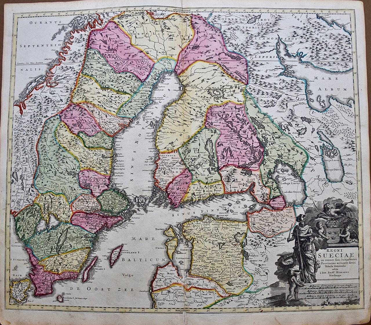
- Sweden and Adjacent Portions of Scandinavia: A Hand-colored 18th C. Homann MapBy Johann Baptist HomannLocated in Alamo, CAThis hand-colored copper-plate map of Sweden and adjacent portions of Scandinavia entitled "Regni Sueciae in Omnes suas Subjacentes Provincias accurate divisi Tabula Generalis" was c...Category
Early 18th Century Old Masters Landscape Prints
MaterialsEngraving
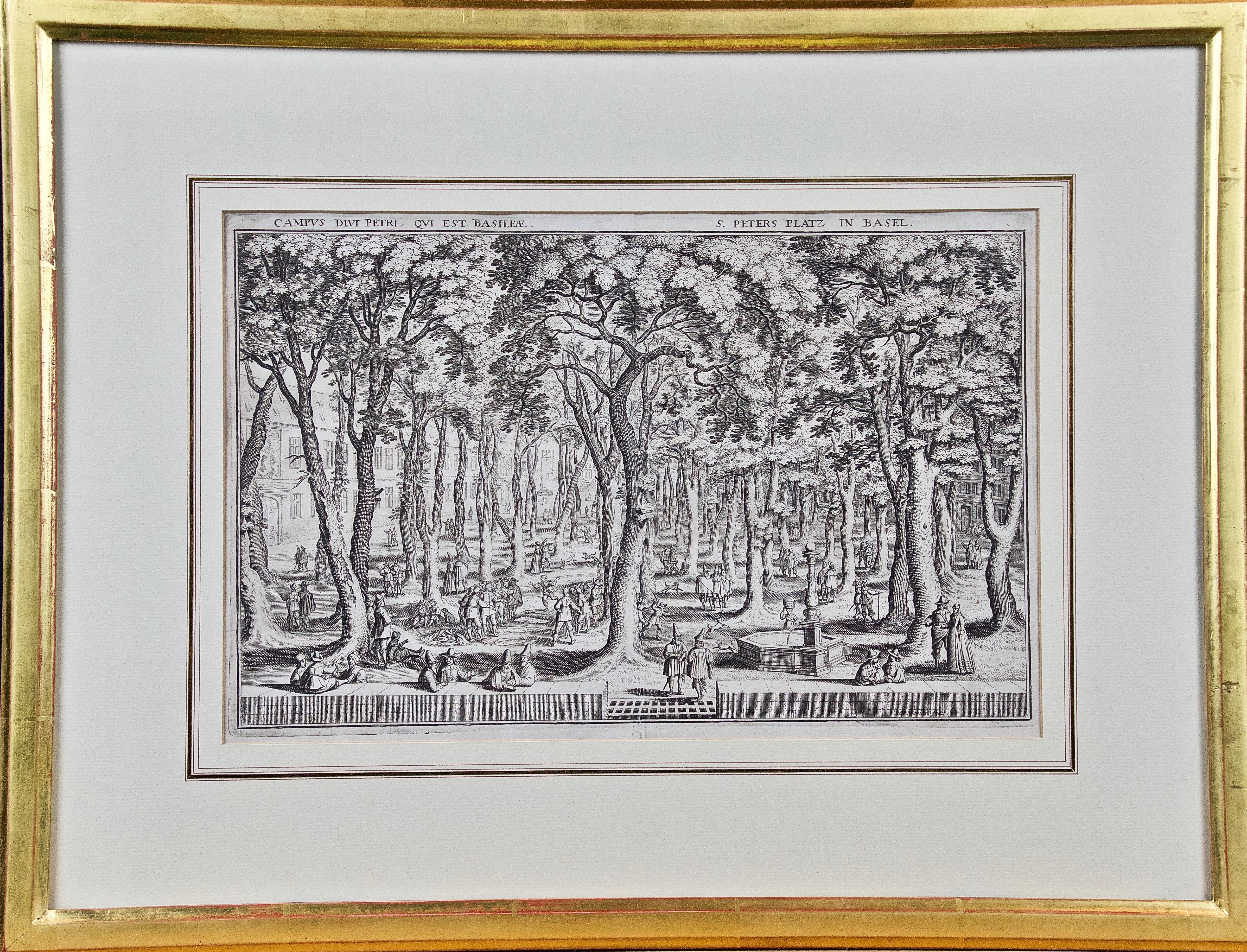
- St. Peter's Square in Basel: 17th Century Engraving by Matthäus MerianBy Matthäus Merian the ElderLocated in Alamo, CA"Campus Divi Petri qui est Basileae" (St. Peter's Platz in Basel) is a 17th century engraving by the old master engraver Matthäus Merian the Elder...Category
1650s Old Masters Landscape Prints
MaterialsEngraving
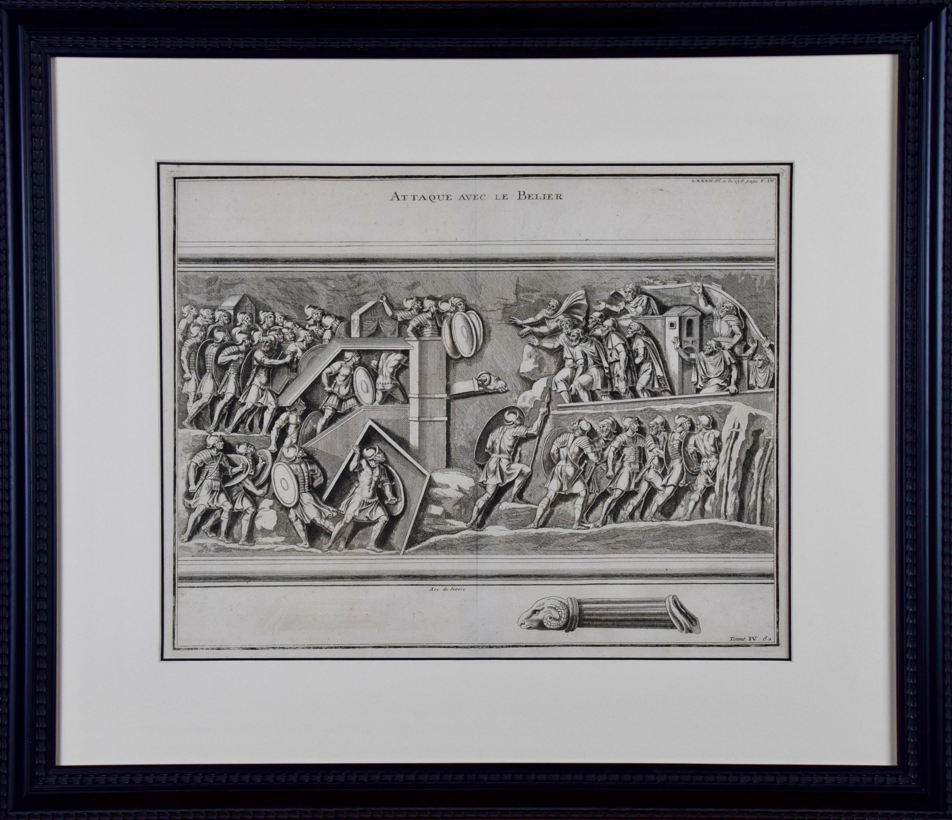
- 18th Century Engraving "Attack with a Battering Ram" by MontfauconLocated in Alamo, CAThis early original copper-plate engraving entitled "Attaque avec le Belier" from 'L'antiquité expliquée et représentée en figures' (Antiquity Explained and Represented in Diagrams), published in Paris in 1719 by Bernard de Montfaucon. It depicts an ancient...Category
Early 18th Century Old Masters Landscape Prints
MaterialsEngraving
- Frankfort, Germany: A 16th Century Hand-colored Map by Braun & HogenbergBy Franz HogenbergLocated in Alamo, CAThis is a 16th century original hand-colored copperplate engraved map of Frankfort, Germany entitled "Francenbergum, vel ut alij Francoburgum Hassiae Opp" by Georg Braun & Franz Hogenberg, from their famous city atlas "Civitates Orbis Terrarum", published in Cologne, Germany in 1595. This is an English translation of an excerpt from the original text in the atlas: "Frankenberg or, according to others, Francoburgum, a town in Hesse. Charlemagne vested the town of Frankenberg with many freedoms and privileges, which it still enjoys to this day, and on account of its valiant and victorious soldiers awarded a signet, upon which there formerly appeared a golden castle with a tower, together with the letter F and a golden crown. Frankenberg, seen here from the northeast, lies on a hill above the River Eder. The hillside is covered with fields neatly separated by bushes and fences. Soaring above the town is the massive Liebfrauenkirche, which was modelled on St Elizabeth's church in Marburg. The New Town was founded in 1335 at the foot of the hill (right) and merged with the Old Town as late as 1556. Frankenberg was founded by Conrad of Thuringia in 1233/34 to prevent the archbishops of Mainz from expanding their sphere of influence...Category
16th Century Old Masters Landscape Prints
MaterialsEngraving
- Danube River, Italy, Greece and Croatia: A Hand-colored 18th C. Homann MapBy Johann Baptist HomannLocated in Alamo, CA"Fluviorum in Europa principis Danubii" is a hand-colored map of the region about the Danube river created by Johann Baptist Homann (1663-1724) in his 'Atlas Novus Terrarum', publish...Category
Early 18th Century Old Masters Landscape Prints
MaterialsEngraving
- Hand Colored 18th Century Homann Map of Austria Including Vienna & the DanubeBy Johann Baptist HomannLocated in Alamo, CA"Archiducatus Austriae inferioris" is a hand colored map of Austria created by Johann Baptist Homann (1663-1724) and published in Nuremberg, Germany in 1728 shortly after his death. ...Category
Early 18th Century Old Masters Landscape Prints
MaterialsEngraving


You May Also Like
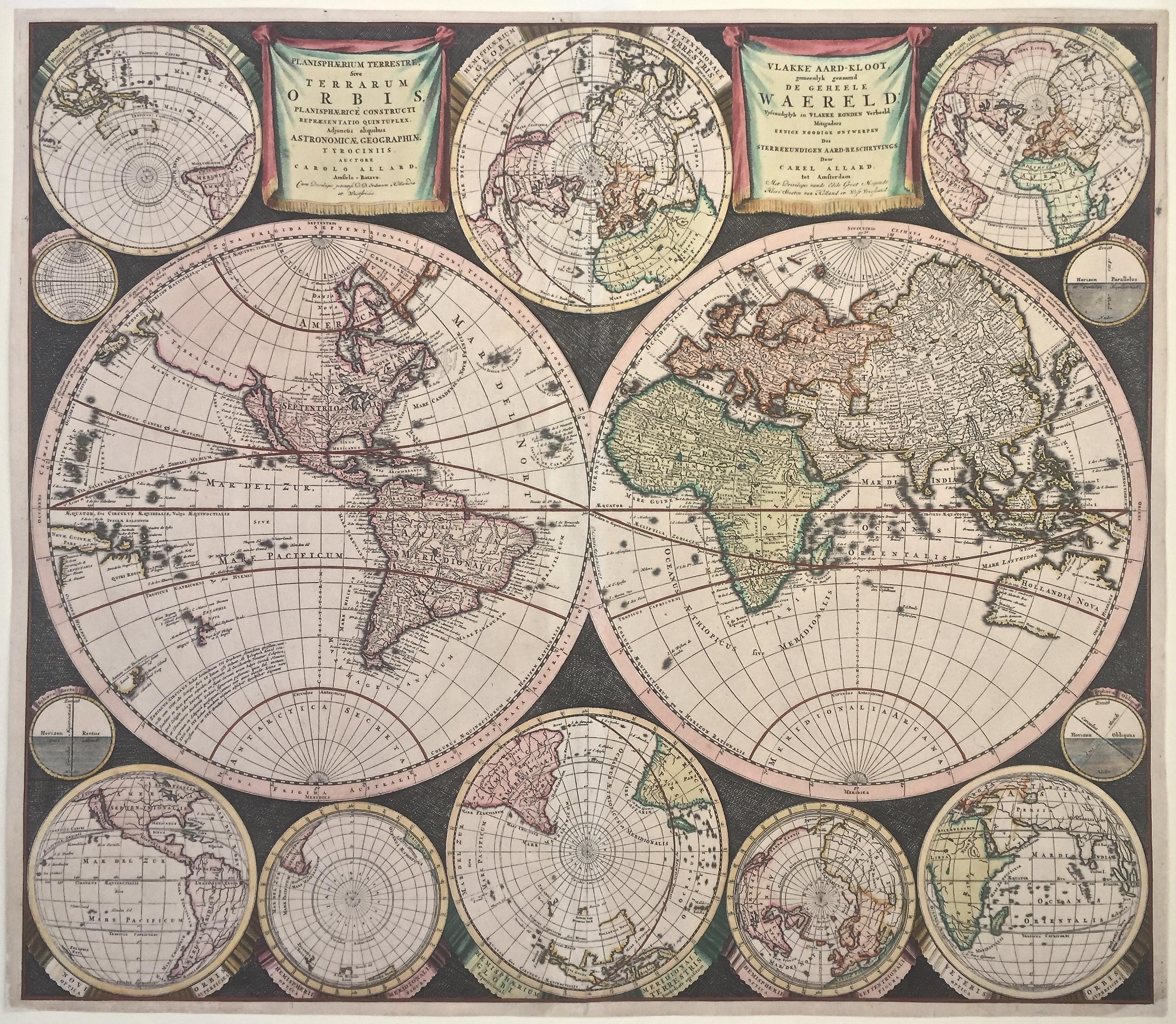
- WORLD MAP - Planisphaerium Terrestre Sive Terrarum Orbis... 1696By Carel AllardLocated in Santa Monica, CACAREL ALLARD (1648 – 1709) PLANISPHAERIUM TERRESTRE SIVE TERRARUM ORBIS… 1696 (Shirley 578) Engraving, 20 ½ x 23 ½”, sheet 21 x 24 1/8". A stunning double hemisphere World Map...Category
17th Century Old Masters Landscape Prints
MaterialsEngraving
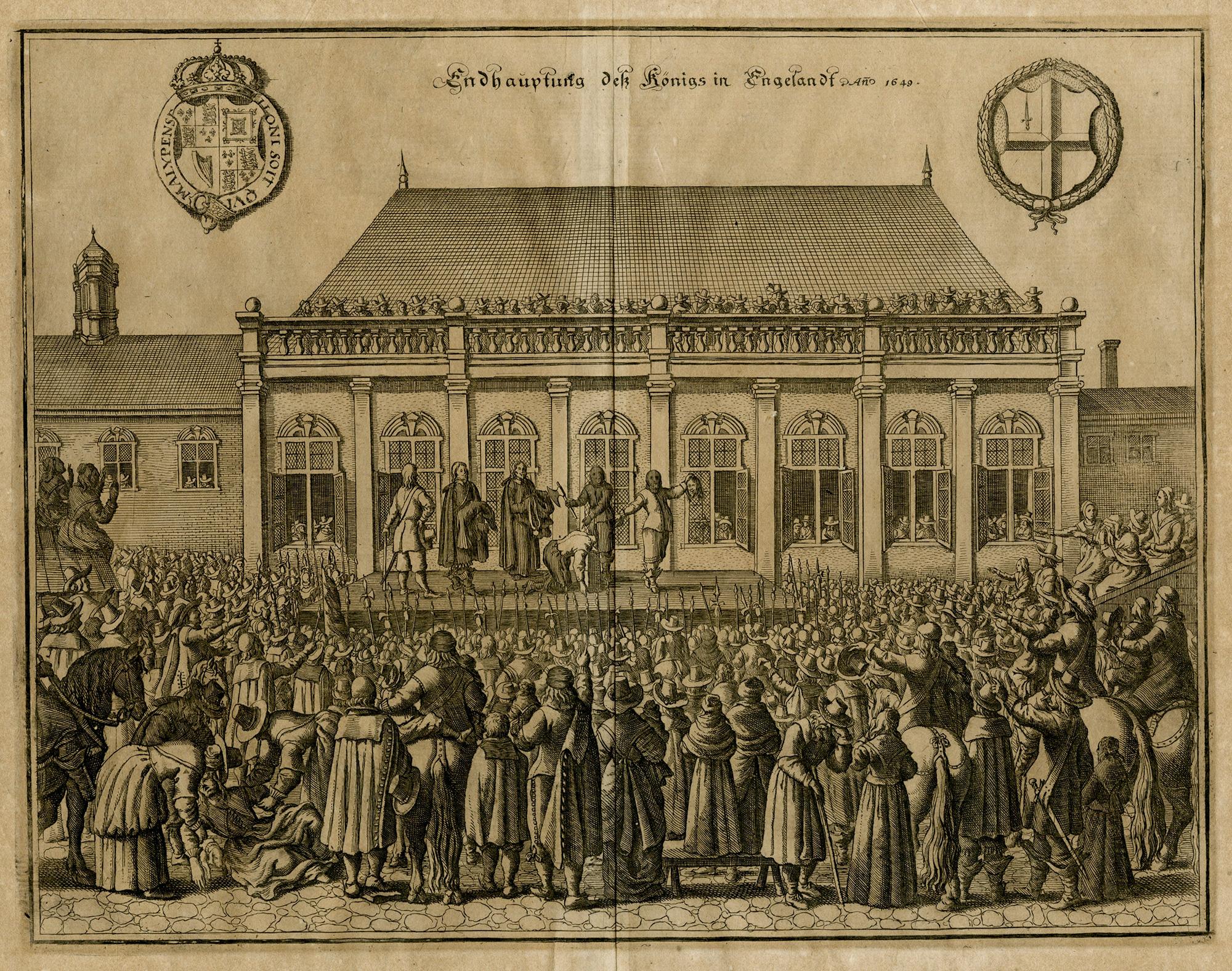
- The Beheading of the King of England; Enthauptung des Königs in EnglandBy Matthäus Merian the ElderLocated in Middletown, NYThe execution of Charles I (1600-1649) at Whitehall, January 30th 1649, in front of the Banqueting House. The executioner holding the head of Charles up to the crowd below. Engravin...Category
Mid-17th Century Old Masters Landscape Prints
MaterialsEngraving, Laid Paper
- The Deluge - JOSEPH MALLORD WILLIAM TURNER (1775 - 1851)By Joseph Mallord William TurnerLocated in Santa Monica, CA(after) JOSEPH MALLORD WILLIAM TURNER (1775 - 1851) THE DELUGE, 1828. Mezzotint, Engraved by I. P. Quilly after a painting by J. M.W. Turner R.A.. Image ...Category
1820s Old Masters Landscape Prints
MaterialsMezzotint
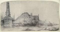
- COTTAGE AND OBELISK ON THE SPAARNDAMMERDIJKBy Rembrandt van RijnLocated in San Francisco, CAOriginal etching and drypoint printed in black ink on laid paper. A strong and dark 17th century/lifetime impression of Bartsch, Usticke and New Hollstein’s second and final stat...Category
18th Century and Earlier Old Masters Landscape Prints
MaterialsDrypoint, Etching
- New Map of the Terraqueous Globe - WORLD MAP - CALIFORNIA AS AN ISLANDBy Edward WellsLocated in Santa Monica, CAEDWARD WELLS (British 1667- 1727) A NEW MAP of the TERRAQUEOUS GLOBE - according to the latest Discoveries and most general Divisions of it into CONTINENTS and OCEANS, 1700-01 (Shirley 609) Engraved by Michael Burghers, Oxford. Hand-colored, Platemark 14 1/4 x 20 1/8 inches. Central cartouche flanked by figures representing the continents with dedication to William, Duke of Gloucester...Category
Early 1700s Old Masters Landscape Prints
MaterialsEngraving
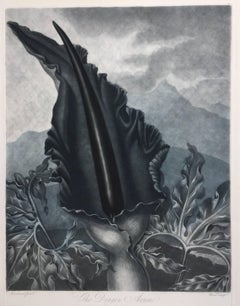
- THE DRAGON ARUMBy Dr. Robert John ThorntonLocated in Santa Monica, CADR. ROBERT JOHN THORNTON (circa 1768- 1837) THE DRAGON ARUM, 1801 (Dunthorne plate 161, pg. 250 i/iii; Nissen 1 955) Mezzotint printed in Payne's grey...Category
Early 1800s Old Masters Landscape Prints
MaterialsMezzotint


Recently Viewed
View AllMore Ways To Browse
17th Century Birds
Small Wood Engraving
British 17th Century
17th Century Copper
Hand Colored Map
17th Century Ship
Old Master Birds
Antique Colored Roses
17th Century Cross
Old English Rose
Hand Compass
Landscaping With Antique Roses
Antique Center Islands
French Map Of America
17th Century Work Table
Old American Maps
17th Century Copper Plate
Hand Colored Bird Engraving