Items Similar to Antique Map of the Holy Land with Picture Frame Border

Want more images or videos?
Request additional images or videos from the seller
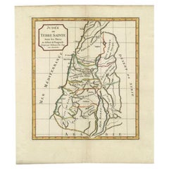
Antique Map of the Holy Land with Picture Frame Border
About the Item
Antique map titled 'Terre Sainte Suivant les Nouvelles Observations (..)'. Original old map of the Holy Land with the picture frame border. The term "Holy Land" usually refers to a territory roughly corresponding to the modern State of Israel and the Palestinian territories. Originates from 'Nouvelle Theatre Du Monde' published by P. van der Aa, 1713.
- Dimensions:Height: 11.66 in (29.6 cm)Width: 17.01 in (43.2 cm)Depth: 0.02 in (0.5 mm)
- Materials and Techniques:
- Period:
- Date of Manufacture:1713
- Condition:Repaired: Repair top right, sl. affecting image. Bottom margin extended. General age-related toning. Shows some wear and creasing. Blank verso. Please study image carefully.
- Seller Location:Langweer, NL
- Reference Number:
About the Seller
5.0
Platinum Seller
These expertly vetted sellers are 1stDibs' most experienced sellers and are rated highest by our customers.
Established in 2009
1stDibs seller since 2017
1,953 sales on 1stDibs
Typical response time: <1 hour
- ShippingRetrieving quote...Ships From: Langweer, Netherlands
- Return PolicyA return for this item may be initiated within 14 days of delivery.
More From This SellerView All
- Antique Map of the Holy Land, c.1717Located in Langweer, NLAntique map Israel titled 'Tabula Geographica Terrae Sanctae'. Rare edition made after a map of the Holy Land by J. Bonfrerius. The map is oriented ...Category
Antique 18th Century Maps
MaterialsPaper
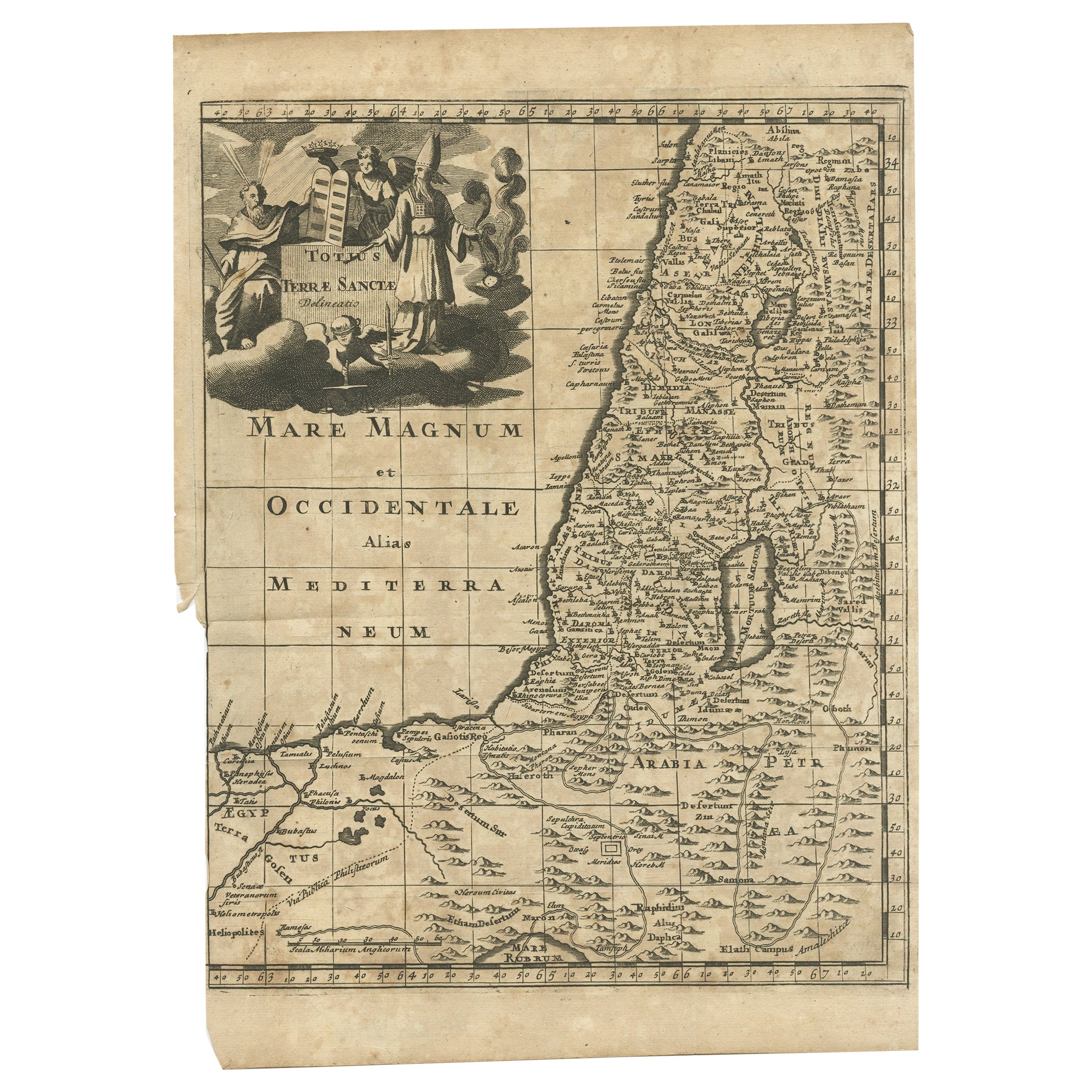
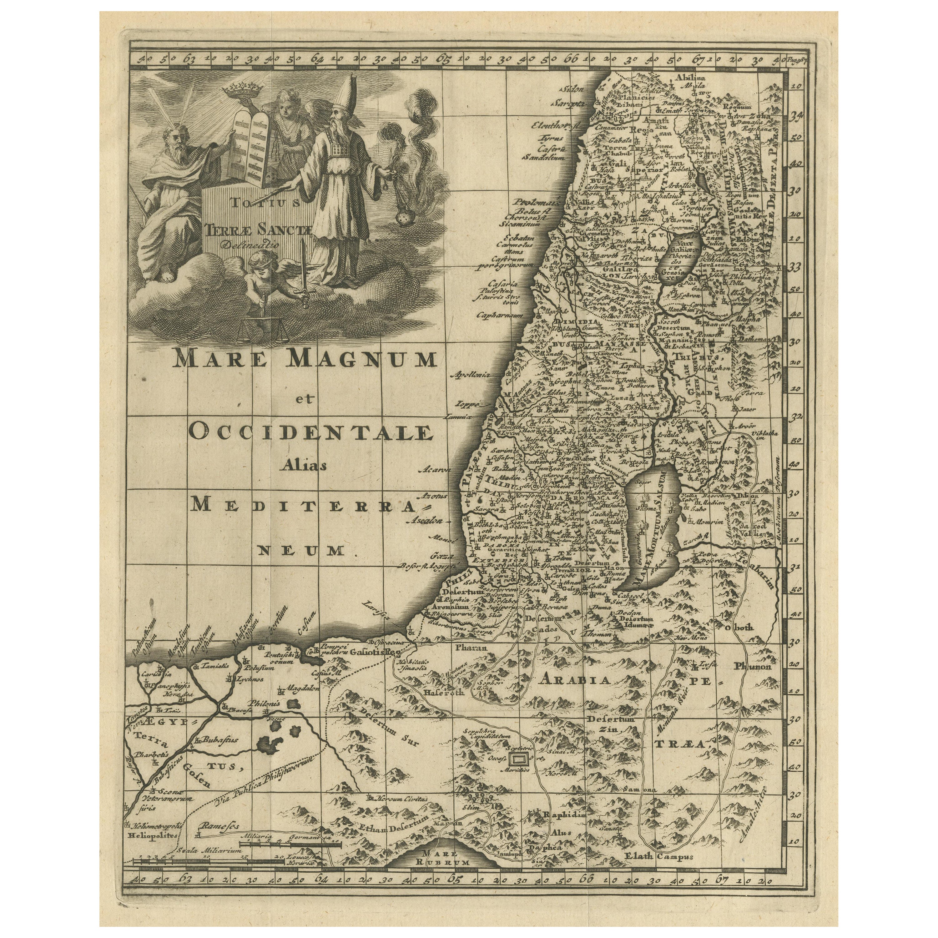
- Antique Map of the Holy Land, c.1710Located in Langweer, NLAntique map titled 'Totius Terrae Sanctae Delineatio'. Map of the Holy Land extending to Egypt and showing the route of the Children of Israel in their e...Category
Antique 18th Century Maps
MaterialsPaper
- Original Antique Map of the Holy Land with Decorative CartoucheLocated in Langweer, NLAntique map titled 'Totius Terrae Sanctae'. Original old map of the Holy Land, with a large decorative cartouche. The term "Holy Land" usually refers to a territory roughly correspon...Category
Antique Late 17th Century Maps
MaterialsPaper
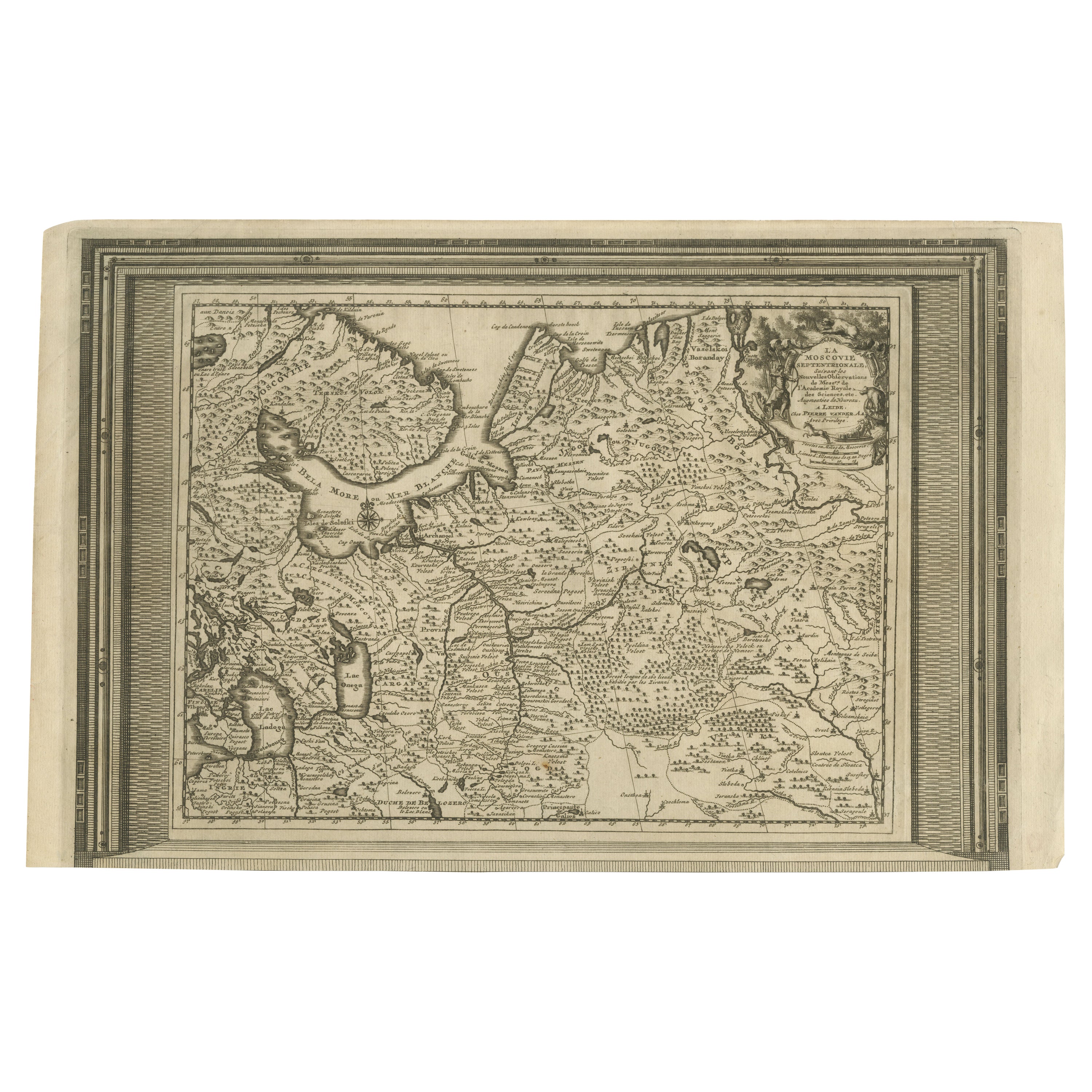
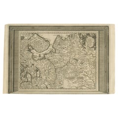
- Antique Map of European Russia with Picture Frame BorderLocated in Langweer, NLAntique map titled 'La Moscovie Septentrionale (..)'. Decorative example of van der Aa's map of the northern part of European Russia. With the picture frame border, which appeared in...Category
Antique Early 18th Century Maps
MaterialsPaper
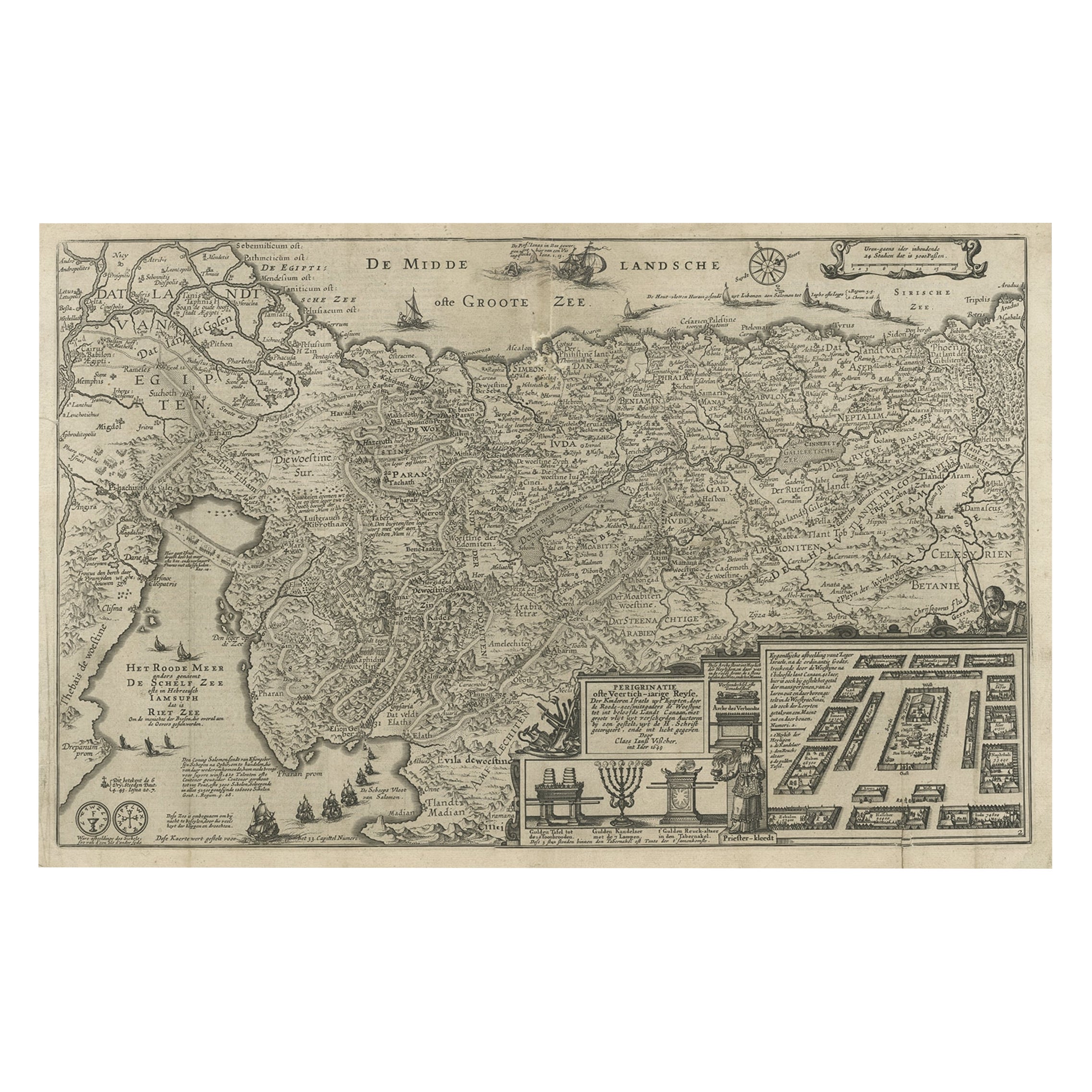
- Beautiful Rare Antique Map of the Holy Land, 1648Located in Langweer, NLAntique map Holy Land titled 'Perigrinatie ofte Veertich-Iarige Reyse, der kinderen Israels uyt Egipten, door de Roode-Zee; mitsgaders de Woestyne tot int Beloofde Landt Canaan, : met groote vlyt uyt verscheryden auctoren by een gestelt, uyt de H. Schrift gecorigeert, ende int licht gegeven'. Beautiful and rare antique map of the Holy Land...Category
Antique 1640s Maps
MaterialsPaper
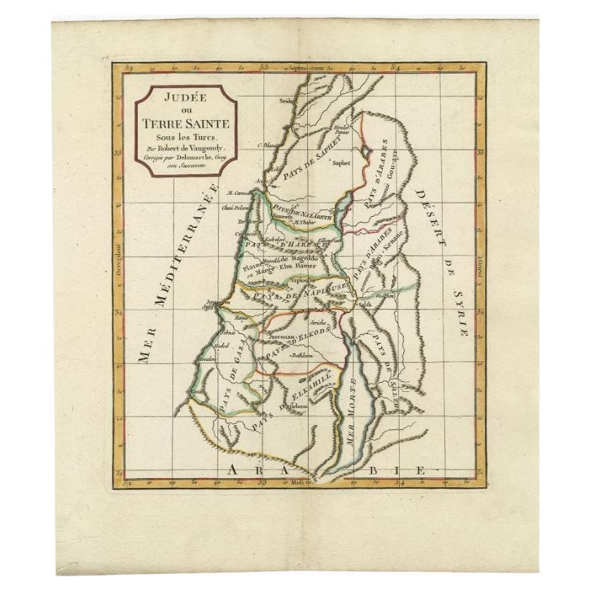
- Antique Map of the Holy Land by Delamarche, 1806By Charles Francois DelamarcheLocated in Langweer, NLAntique map titled 'Judee ou Terre Sainte sous les Turcs.' This map shows the holy land under the Turcs. By Robert de Vaugondy, revised and published by ...Category
Antique 19th Century Maps
MaterialsPaper


You May Also Like
- The Holy Land at the Time of Jesus: A 17th Century Dutch Map by VisscherBy Nicolaes Visscher IILocated in Alamo, CAThis detailed Dutch map entitled "Het Beloofe de Landt Canaan door wandelt van onsen Salichmaecker Iesu Christo, nessens syne Apostelen" by Nicolaes Visscher was published in Amsterd...Category
Antique Mid-17th Century Dutch Maps
MaterialsPaper
- Flowers from The Holy Land souvenir bookLocated in East Geelong, VICContained within the olive wood covers of this Flowers from The Holy Land souvenir book are 11 thick cardboard pages, 10 of which have pressed flowers arranged on them. The flowers a...Category
Antique 1890s Israeli Books
MaterialsPaper
- Map of the Holy Land "Carte de la Syrie et de l'Egypte" by Pierre M. LapieBy Pierre M. LapieLocated in Alamo, CAAn early 19th century map of ancient Syria and Egypt entitled "Carte de la Syrie et de l'Egypte anciennes/dressée par M. Lapie, Colonel d'Etat Major, et...Category
Antique Early 19th Century French Maps
MaterialsPaper
- Map Holy Promise Land Canaan Richard Palmer Richard Blome 1687 Joseph MoxonLocated in BUNGAY, SUFFOLKCanaan comonly called the Holy Land or the Land of Promise, being the Possesion of the Israelites & travelled through by Our Lord & Saviour Iesus Christ and his Apostles. Engraven by Richard Palmer for Richard Blome. 1687 Blome, Richard, 1641-1705. London. 283 x 452 mm. Copperplate. Probably from an English Bible...Category
Antique 17th Century British Baroque Maps
MaterialsPaper
- Framed Original Land Map Survey of Tyler Park, Jersey City RailroadLocated in Lambertville, NJA framed and matted historical map of Tyler park jersey city New Jersey Railroad. The paper on canvas in later appropriate frame. Good condition with some creasing and age discolorat...Category
Antique 1870s American Posters
MaterialsCanvas, Glass, Wood
- Large Framed Map of the MediterraneanLocated in New York, NYLarge map/chart chart of The Mediterranean and the Grecian Archipelago showing Italy, Sardinia, Corsica, part of France, etc. in a black frame.Category
20th Century French Mid-Century Modern Maps


Recently Viewed
View AllMore Ways To Browse
Old Chinese Map
Map Of Louisiana
Papua New Guinea Antique Map
Map Of The Bahamas
Antique Map Tuscany
Antique Maps Surrey
Richmond Map
Charlotte Reine
Republic Of Texas Map
Antique Map Bahamas
Antique Maps Of Puerto Rico
Cheshire Antique Map
Map Of Washington Dc
Washington Dc Map
Antique Map Of New Hampshire
Auge En Pierre
Buenos Ayres
Map Lebanon