Items Similar to Antique Map of the Region of Liege by Coronelli, 1690
Want more images or videos?
Request additional images or videos from the seller
1 of 5
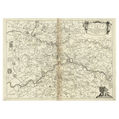
Antique Map of the Region of Liege by Coronelli, 1690
About the Item
Antique map titled 'Vescovato di Liege (..)'. Map of the Belgium area centered on Liege and the course of Meuse/Maas River. Also depicts the cities of Maastricht, Namur and Tienen. Originates from 'Corso Geografico Universale'.
Artists and Engravers: The remarkable Vincenzo Coronelli (1650-1718), encyclopaedist, geographer, inventor and Doctor of Theology, was citizen of the Republic of Venice. He was also one of the most prominent mapmakers and publishers in Europe of his day.
Condition: Good, general age-related toning. Please study image carefully.
Date: 1690
Overall size: 68 x 48.5 cm.
Image size: 58.5 x 43 cm.
We sell original antique maps to collectors, historians, educators and interior decorators all over the world. Our collection includes a wide range of authentic antique maps from the 16th to the 20th centuries. Buying and collecting antique maps is a tradition that goes back hundreds of years. Antique maps have proved a richly rewarding investment over the past decade, thanks to a growing appreciation of their unique historical appeal. Today the decorative qualities of antique maps are widely recognized by interior designers who appreciate their beauty and design flexibility. Depending on the individual map, presentation, and context, a rare or antique map can be modern, traditional, abstract, figurative, serious or whimsical. We offer a wide range of authentic antique maps for any budget.
- Creator:Vincenzo Coronelli (Artist)
- Dimensions:Height: 19.1 in (48.5 cm)Width: 26.78 in (68 cm)Depth: 0 in (0.01 mm)
- Materials and Techniques:
- Period:
- Date of Manufacture:1690
- Condition:Condition: Good, general age-related toning. Please study image carefully.
- Seller Location:Langweer, NL
- Reference Number:
About the Seller
5.0
Platinum Seller
These expertly vetted sellers are 1stDibs' most experienced sellers and are rated highest by our customers.
Established in 2009
1stDibs seller since 2017
1,966 sales on 1stDibs
Typical response time: <1 hour
- ShippingRetrieving quote...Ships From: Langweer, Netherlands
- Return PolicyA return for this item may be initiated within 14 days of delivery.
More From This SellerView All
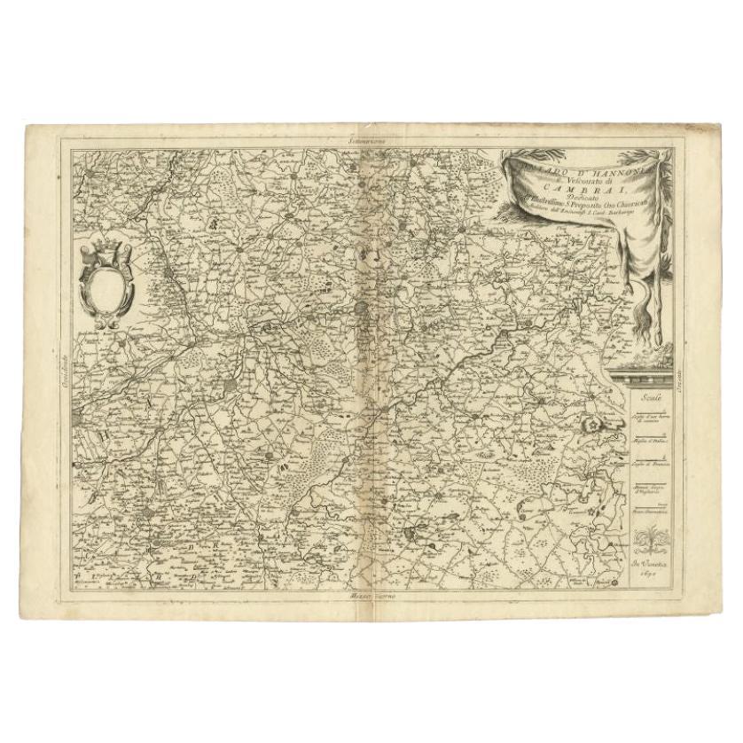
- Detailed Antique Map of Western Belgium and Eastern France by Coronelli, 1690By Vincenzo CoronelliLocated in Langweer, NLAntique map titled 'Contado d'Hannonia (..)'. Map of western Belgium and eastern France, from south of Brussels (not shown) to Cambrai, France, generally centered around the towns of...Category
Antique 17th Century Maps
MaterialsPaper
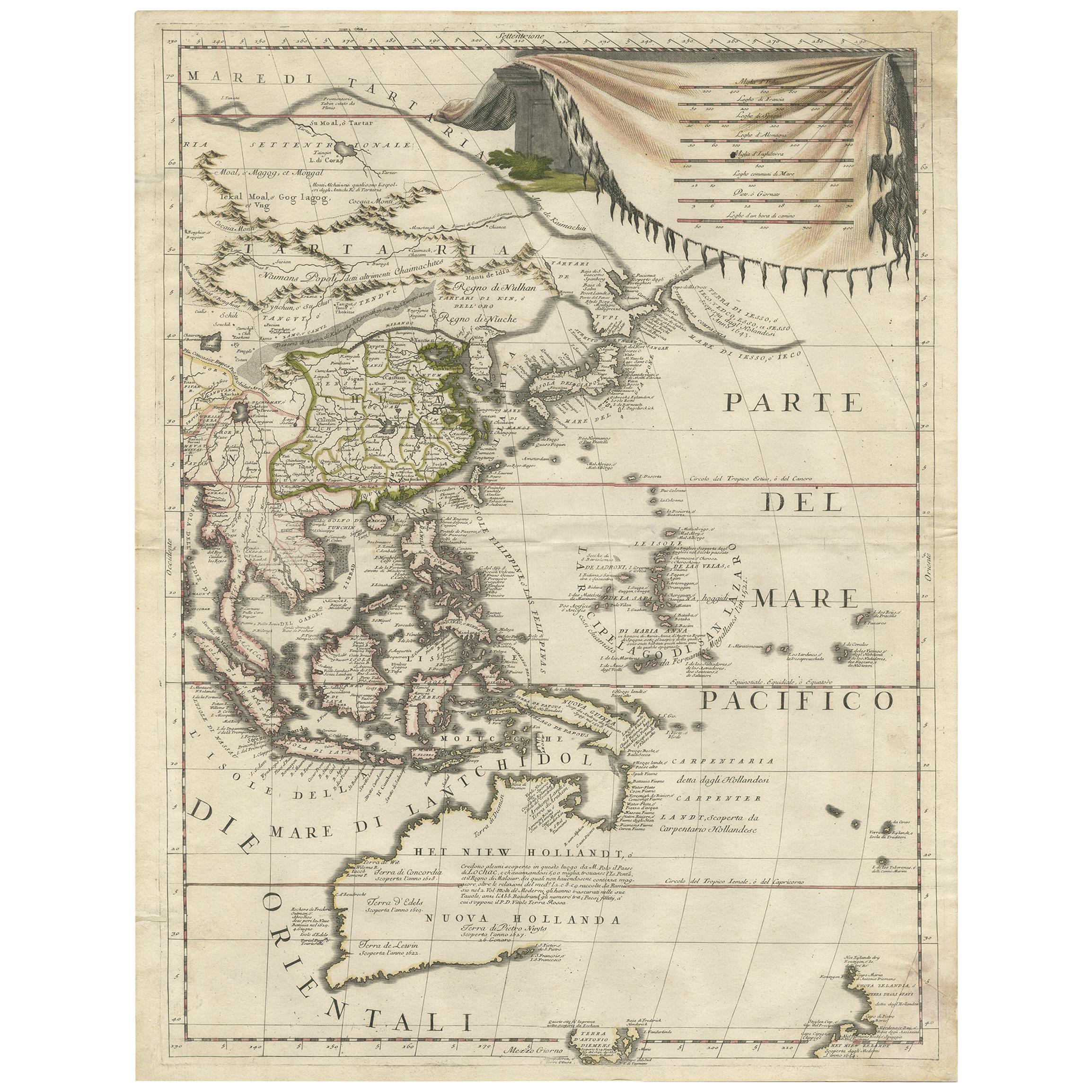
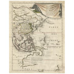
- Antique Map of East Asia by Coronelli, circa 1690Located in Langweer, NLAntique map of East Asia showing New Holland and parts of Van Diemens Land and New Zealand. This map is the right hand part of a two sheet map, but is complete on its own. This map o...Category
Antique Late 17th Century Maps
MaterialsPaper
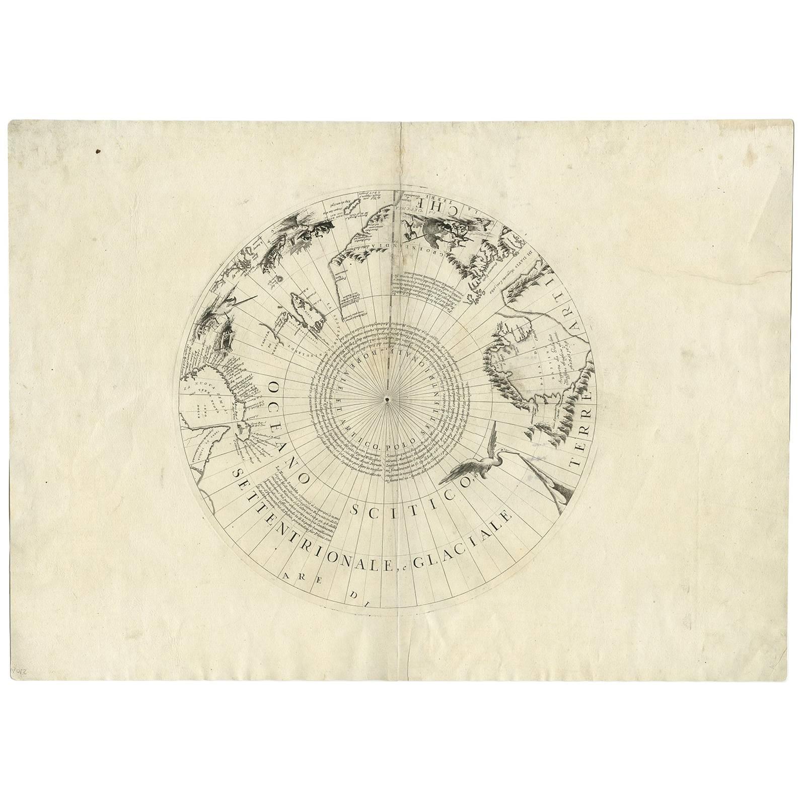
- Antique Map of the North Pole by V.M. Coronelli, circa 1692By Vincenzo CoronelliLocated in Langweer, NLGlobe gore by Vincenzo Maria Coronelli shows the North Pole with the coasts of Canada, Greenland, Scandinavia and Siberia, and is decorated with pictorial scenes of bear, seal and wh...Category
Antique Late 17th Century Maps
MaterialsPaper
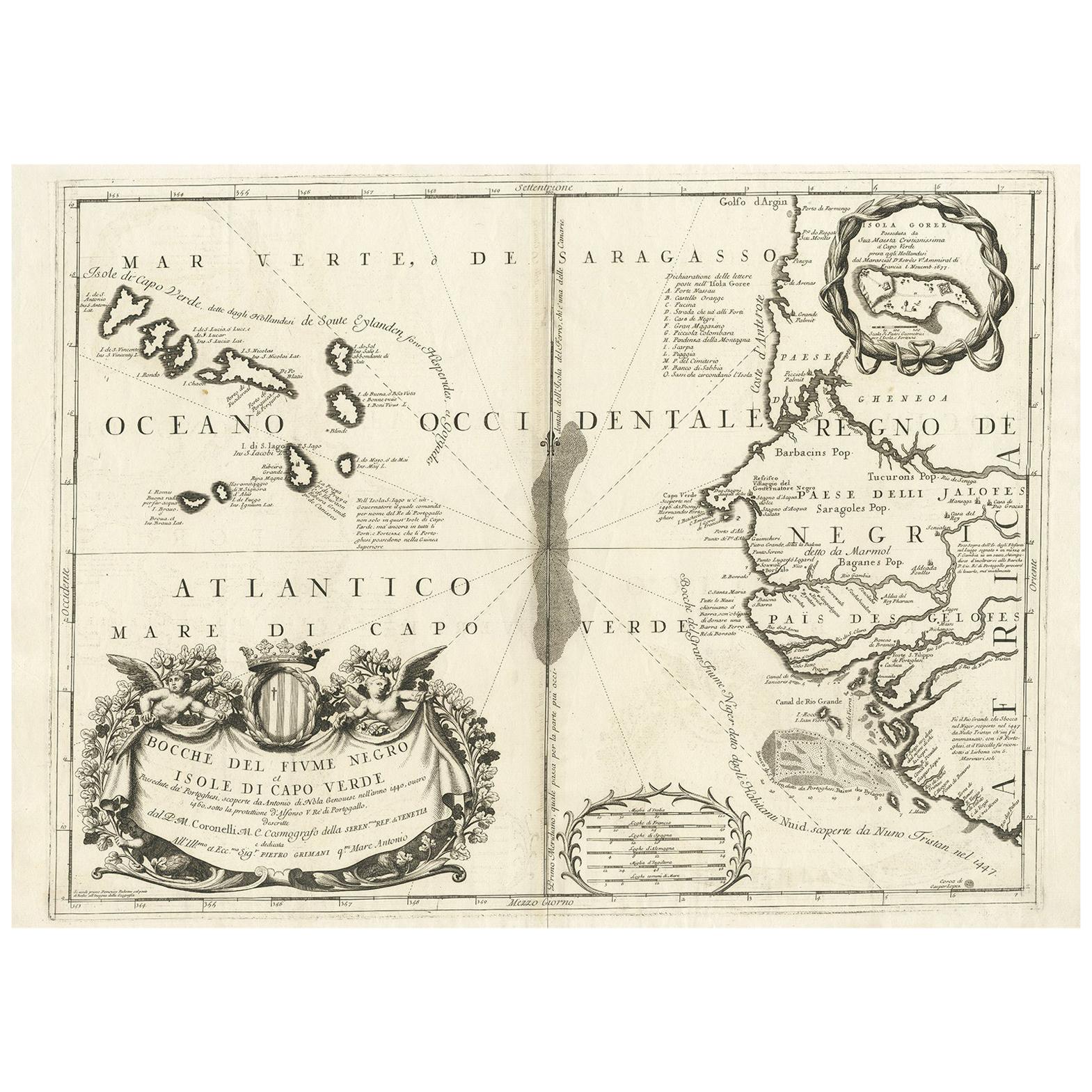
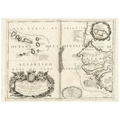
- Antique Map of Western Africa and the Cape Verde Islands by Coronelli, 1691By Vincenzo CoronelliLocated in Langweer, NLAntique map titled 'Bocche del Fiume Negro et Isole di Capo Verde'. Antique map of Western Africa with the Cape Verde Islands and an inset of Goree Island. Originates from 'Atlante V...Category
Antique Late 17th Century Italian Maps
MaterialsPaper
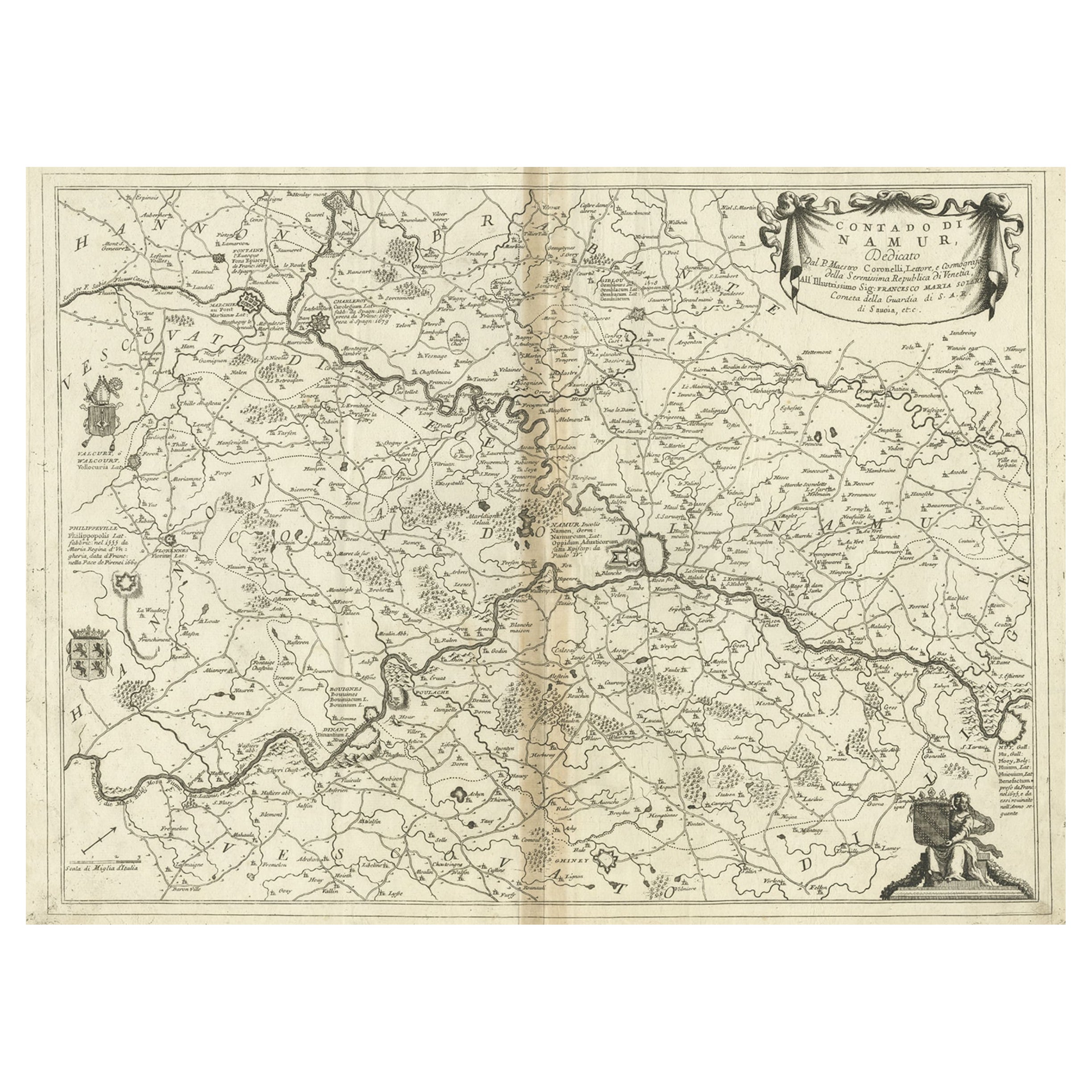
- Antique Map of the Namur Region in France by Coronelli, c.1695By Vincenzo CoronelliLocated in Langweer, NLAntique map titled 'Contado di Namur (..)'. Old map of the Namur region in central Belgium. Includes several coats of arms. Artists and Engravers: The remarkable Vincenzo Coronell...Category
Antique 17th Century Maps
MaterialsPaper
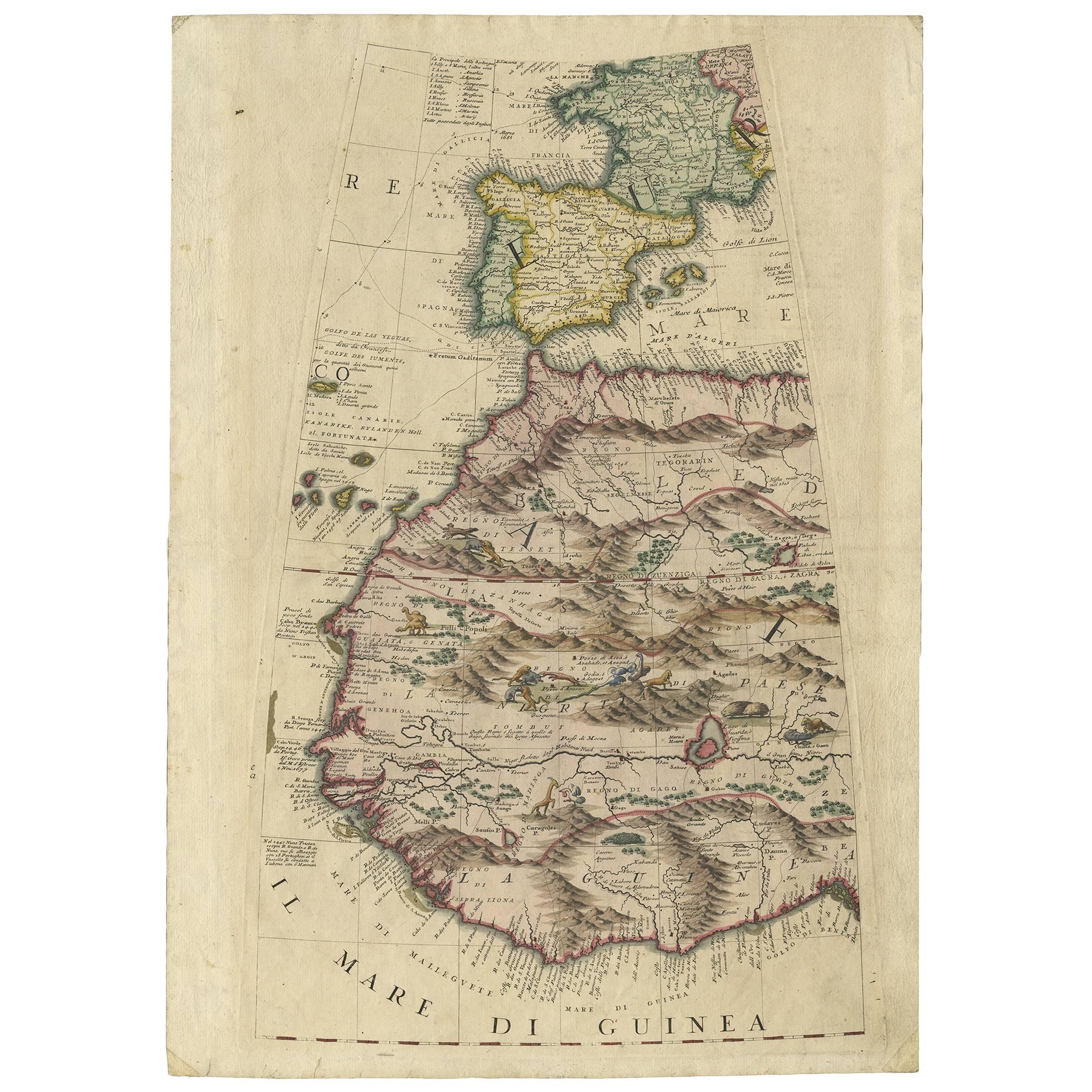
- Rare Antique Map of Southwestern Europe and West Africa by V.M. Coronelli, 1692By Vincenzo CoronelliLocated in Langweer, NLBeautiful hand-colored example of the Southwestern Europe and West Africa globe gore from Coronelli's 42 inch Terrestrial Globe. The globe gore embraces France, Iberia and all of Africa west of a line running from Algeria down to the Bight of Benin, as well as the Canary Islands and Madeira. One of the most accurate and finely engraved cartographic depictions of its era, the coastline of Africa appears in well-formed detail. The interior, which was an almost complete enigma, is adorned with mythical mountain ranges and exotic animals such as giraffes, elephants, lions and strange giant birds. The Gambia...Category
Antique Late 17th Century Maps
MaterialsPaper


You May Also Like
- 17th Century Hand Colored Map of the Liege Region in Belgium by VisscherBy Nicolaes Visscher IILocated in Alamo, CAAn original 17th century map entitled "Leodiensis Episcopatus in omnes Subjacentes Provincias distincté divisusVisscher, Leodiensis Episcopatus" by Nicolaes Visscher II, published in Amsterdam in 1688. The map is centered on Liege, Belgium, includes the area between Antwerp, Turnhout, Roermond, Cologne, Trier and Dinant. This attractive map is presented in a cream-colored mat measuring 30" wide x 27.5" high. There is a central fold, as issued. There is minimal spotting in the upper margin and a tiny spot in the right lower margin, which are under the mat. The map is otherwise in excellent condition. The Visscher family were one of the great cartographic families of the 17th century. Begun by Claes Jansz Visscher...Category
Antique Late 17th Century Dutch Maps
MaterialsPaper
- The Normandy Region of France: A 17th C. Hand-colored Map by Sanson and JaillotBy Nicolas SansonLocated in Alamo, CAThis large hand-colored map entitled "Le Duché et Gouvernement de Normandie divisée en Haute et Basse Normandie en divers Pays; et par evêchez, avec le Gouvernement General du Havre ...Category
Antique 1690s French Maps
MaterialsPaper
- Original Antique Map of The World by Thomas Clerk, 1817Located in St Annes, LancashireGreat map of The Eastern and Western Hemispheres On 2 sheets Copper-plate engraving Drawn and engraved by Thomas Clerk, Edinburgh. Published by Mackenzie And Dent, 1817 ...Category
Antique 1810s English Maps
MaterialsPaper
- 17th Century Hand-Colored Map of a Region in West Germany by JanssoniusBy Johannes JanssoniusLocated in Alamo, CAThis attractive highly detailed 17th century original hand-colored map is entitled "Archiepiscopatus Maghdeburgensis et Anhaltinus Ducatus cum terris adjacentibus". It was published ...Category
Antique Mid-17th Century Dutch Maps
MaterialsPaper
- Original Antique Map of The Netherlands, Engraved by Barlow, Dated 1807Located in St Annes, LancashireGreat map of Netherlands Copper-plate engraving by Barlow Published by Brightly & Kinnersly, Bungay, Suffolk. Dated 1807 Unframed.Category
Antique Early 1800s English Maps
MaterialsPaper
- Map of the Republic of GenoaLocated in New York, NYFramed antique hand-coloured map of the Republic of Genoa including the duchies of Mantua, Modena, and Parma. Europe, late 18th century. Dimension: 25...Category
Antique Late 18th Century European Maps


Recently Viewed
View AllMore Ways To Browse
Belgium Map
Antique Map Venice
Antique Maps Venice
Antique Map Of Venice
Antique Map By Coronelli
18th Century Antique Mexican
Antique Pirate
Medieval Capital
Pirate Antique
Antique Furniture Columbus
Antique Map Of Georgia
Antique Map Of The West Indies
Antique Maps West Indies
Ceylon Map
German Compass
Maps Tallis
West Indies Antique Map
Bay Area Antique Furniture