Items Similar to 18th Century Antique Map of the Virgin Islands and Caribbean Inset Maps

Want more images or videos?
Request additional images or videos from the seller
1 of 9
18th Century Antique Map of the Virgin Islands and Caribbean Inset Maps
About the Item
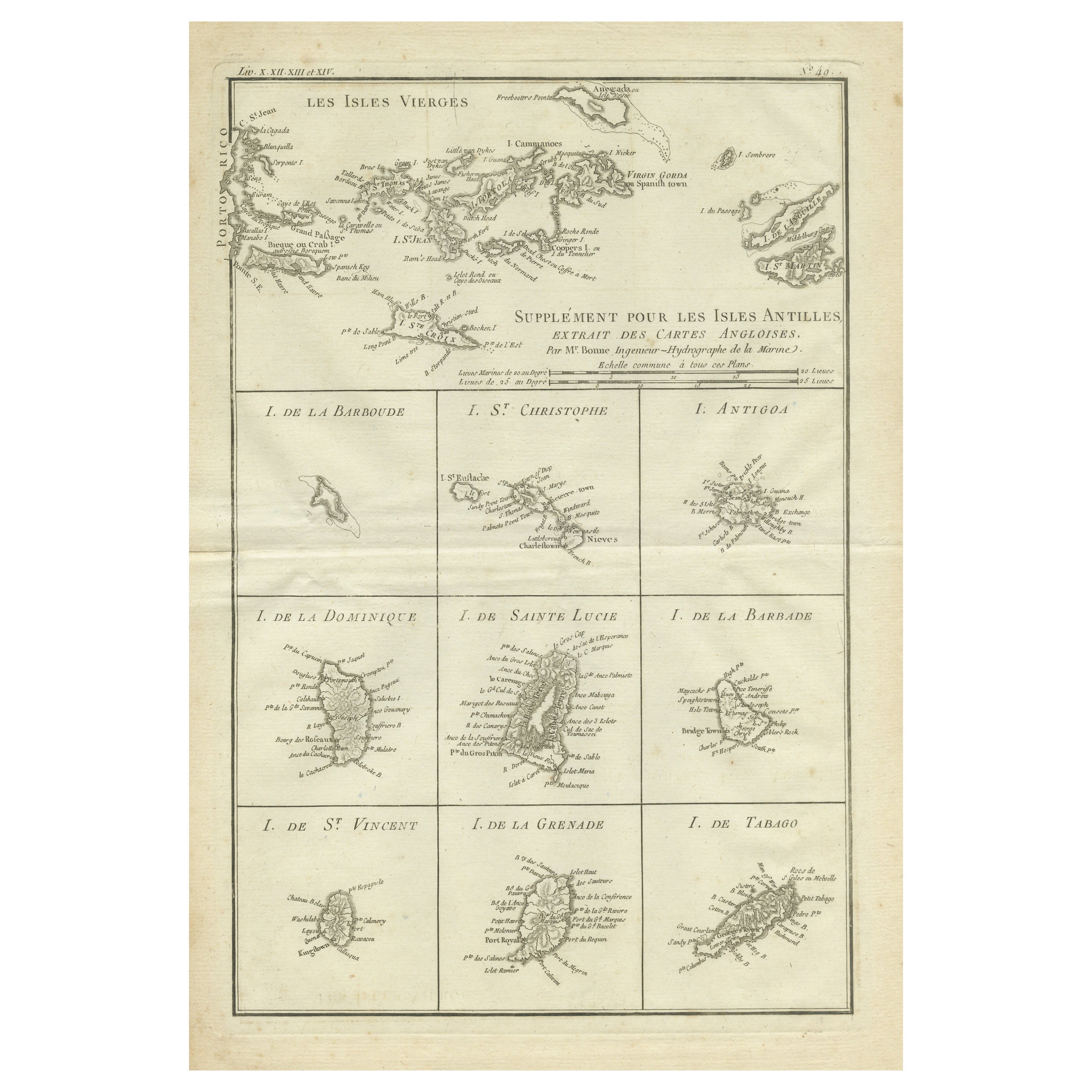
A fascinating piece of cartographic history! The map, titled "Carte du supplément pour les Isles Antilles," featuring inset maps of various islands in the Caribbean, is from the "Atlas Encyclopedique" by Rigobert Bonne and Nicolas Desmarest.
Rigobert Bonne (1727–1795) was a French cartographer known for his precise and detailed maps, while Nicolas Desmarest (1725–1815) was a French geographer and cartographer. Their collaboration resulted in the "Atlas Encyclopedique," a comprehensive atlas that included maps covering various regions of the world.
The map, with its insets of islands such as St. Kitts, Antigua, Dominica, St. Lucia, Barbados, St. Vincent, Grenada, and Tobago, provides a glimpse into the geography of the Caribbean during the late 18th century. Maps from this period are not only aesthetically beautiful but also serve as valuable historical documents, shedding light on the exploration and understanding of the world at that time.
Given its age and historical significance, this antique map is likely to be of interest to collectors, historians, or enthusiasts of cartography and Caribbean history.
- Dimensions:Height: 12.68 in (32.2 cm)Width: 18 in (45.7 cm)Depth: 0.02 in (0.5 mm)
- Materials and Techniques:
- Period:
- Date of Manufacture:1788
- Condition:General age-related toning. Original folding line, some soiling. Blank verso. Please study image carefully.
- Seller Location:Langweer, NL
- Reference Number:
About the Seller
5.0
Platinum Seller
These expertly vetted sellers are 1stDibs' most experienced sellers and are rated highest by our customers.
Established in 2009
1stDibs seller since 2017
1,967 sales on 1stDibs
Typical response time: <1 hour
- ShippingRetrieving quote...Ships From: Langweer, Netherlands
- Return PolicyA return for this item may be initiated within 14 days of delivery.
More From This SellerView All
- Original Antique Map of the Virgin Islands with Insets of Caribbean Isles, 1787Located in Langweer, NLAntique map titled 'Supplément pour les Isles Antilles (..)'. Original old map of the Virgin Islands, with insets of Barbuda, St. Kits, Antigua, Dominica, St. Lucia, Barbados, St. Vi...Category
Antique Late 18th Century Maps
MaterialsPaper
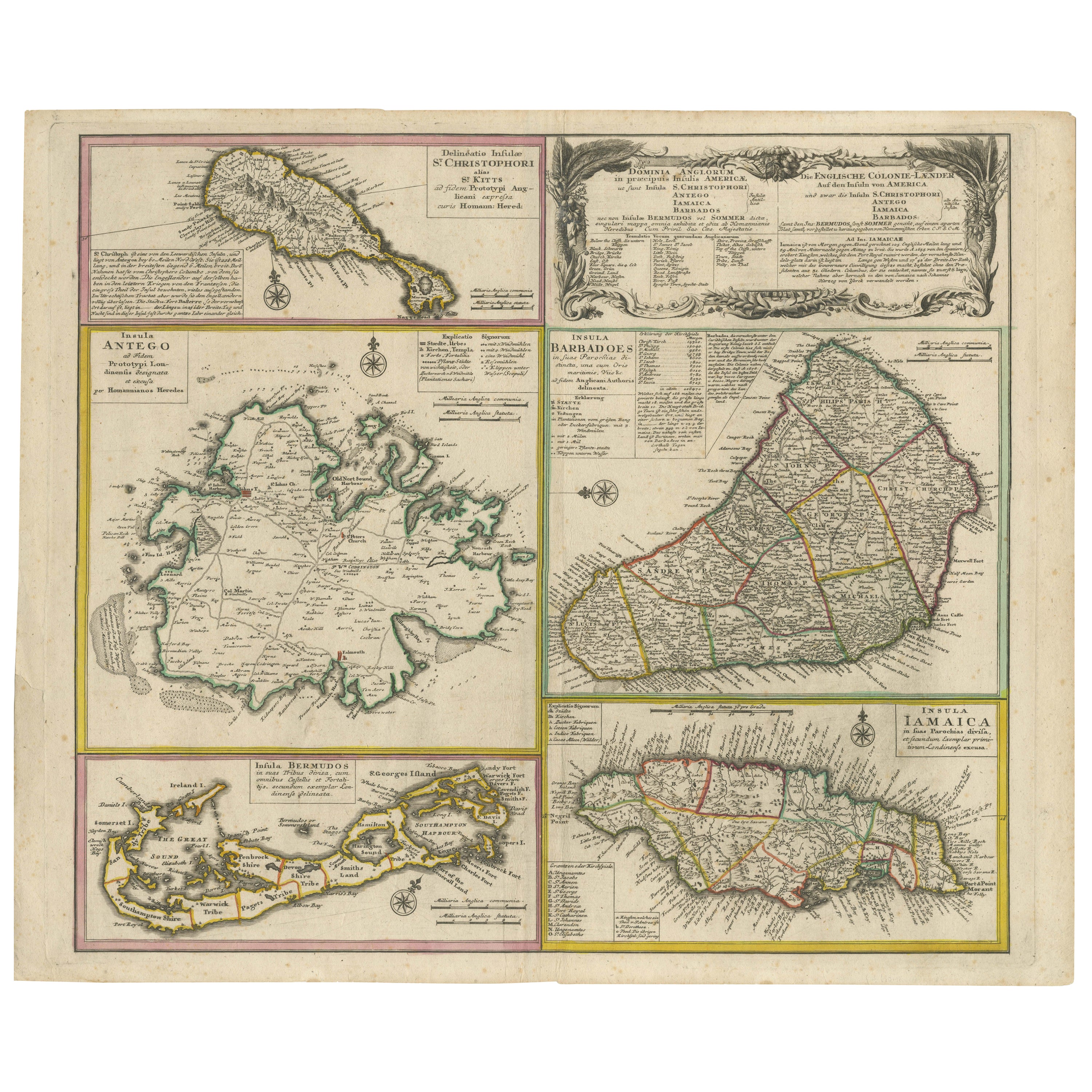
- Old 18th Century Composite Map of Key Caribbean Islands with Descriptive TextsLocated in Langweer, NLAntique map titled 'Dominia Anglorum in praecipuis Insulis Americae ut sunt Insula S. Christophori, Antegoa, Iamaica, Barbados nec non Insulae Bermudes vel Sommers dictae. Die Englis...Category
Antique 1740s Maps
MaterialsPaper
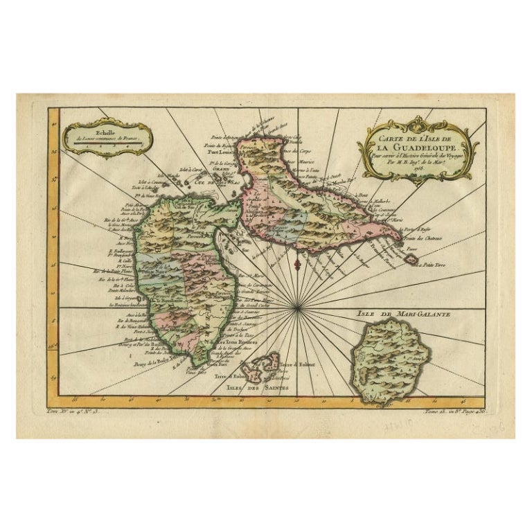
- Antique Map of Guadeloupe, Island in the Caribbean, c.1757Located in Langweer, NLAntique map titled 'Carte de L'Isle de la Guadeloupe'. A very decorative map of Guadeloupe in the Caribbean, adorned with rhumb lines, fleur-de-lys, and two decorative rococo-style...Category
Antique 18th Century Maps
MaterialsPaper
- Detailed Antique Map of the Windward Islands in the CaribbeanBy Covens & MortierLocated in Langweer, NLAntique map titled 'Carte des Antilles Francoises et des Isles Voisines'. Original antique map of the French Antilles, covering an area stretching from Guadeloupe in the north to Gre...Category
Antique Early 18th Century Maps
MaterialsPaper
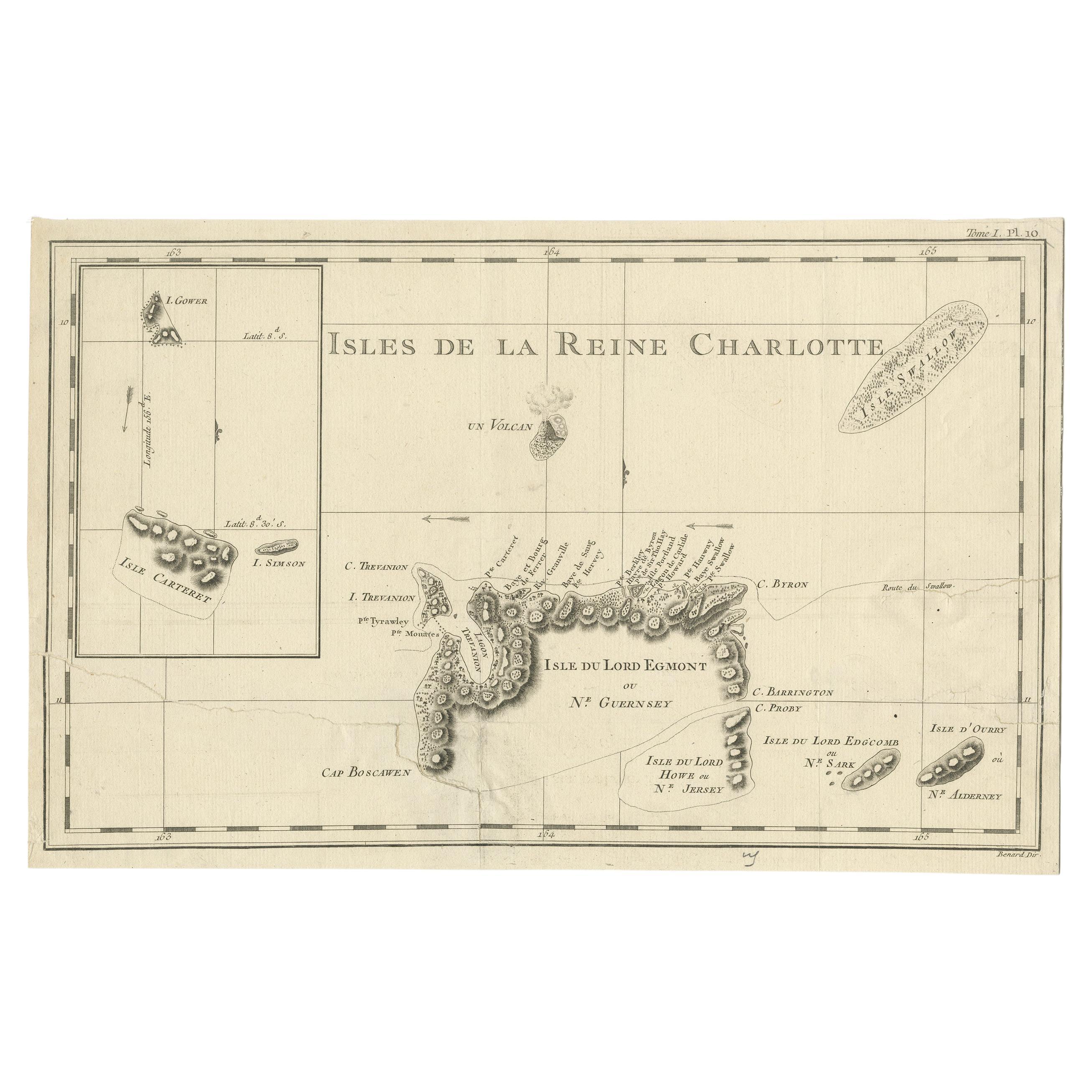
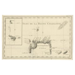
- Antique Map of the Santa Cruz Islands with Inset of Carteret and Gower IslandsLocated in Langweer, NLAntique map titled 'Isles de la Reine Charlotte (..)'. A detailed chart of the Santa Cruz islands, to the north of the New Hebrides, with Carteret's track in "Swallow"; including an ...Category
Antique Late 18th Century Maps
MaterialsPaper
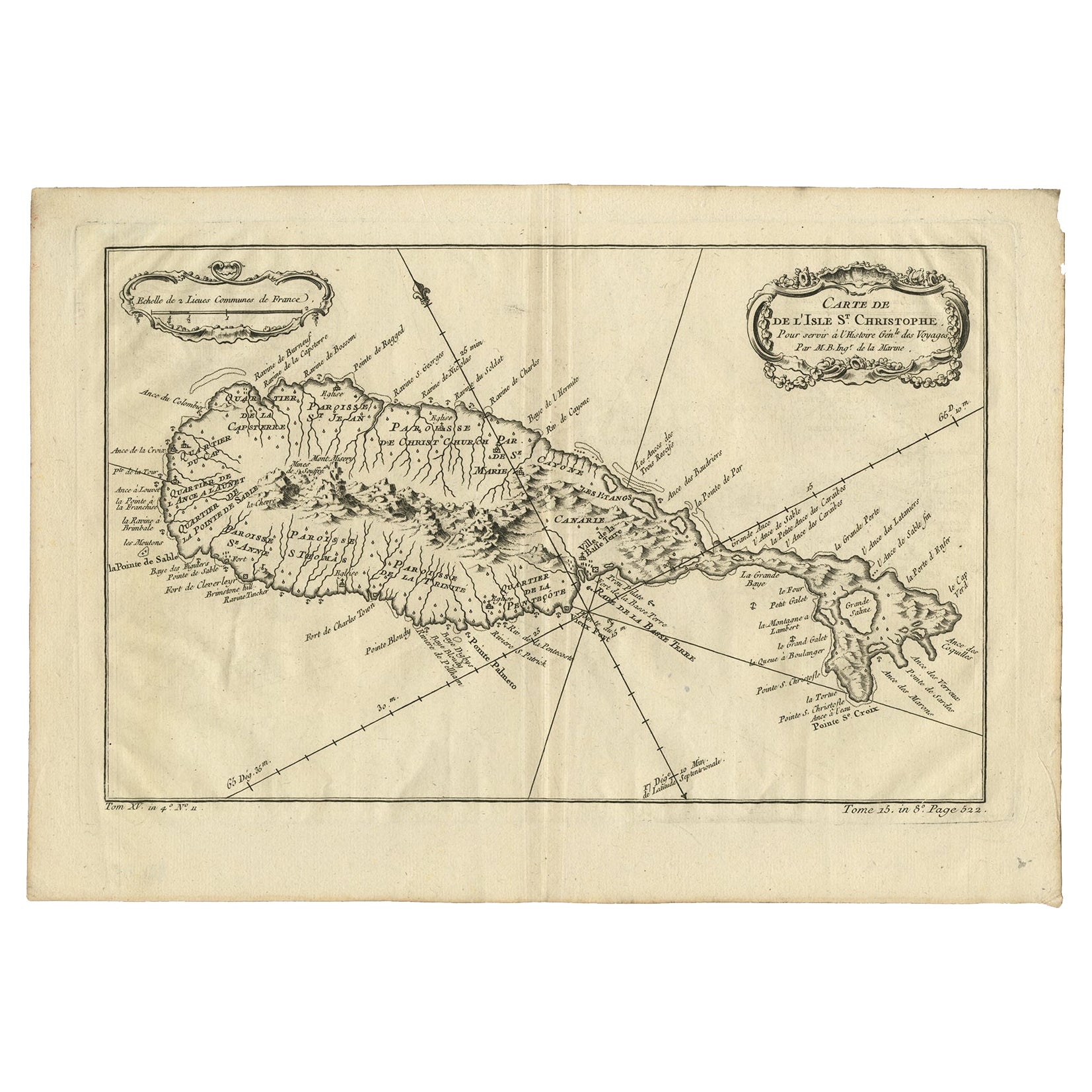
- Antique Map of the Caribbean Island of St Kitts, ca.1750Located in Langweer, NLDescription: Antique map titled 'Carte de l'Isle St. Christophe pour Servir a l'Histoire Genle. des Voyages.' Detailed map of the Island of St. Kitts, showing the Parishes, towns, ...Category
Antique 1750s Maps
MaterialsPaper

You May Also Like
- Early 19th Century Hand Colored Map of the United States and Caribbean IslandsLocated in Hamilton, OntarioHand coloured early 19th century map by Giraldon of France titled "Etats Unis et Grandes Antilles" (United States and Greater Antilles).Category
Antique Early 19th Century French Maps
MaterialsPaper
- Hand-Colored 18th Century Homann Map of Denmark and Islands in the Baltic SeaBy Johann Baptist HomannLocated in Alamo, CAAn 18th century copper plate hand-colored map entitled "Insulae Danicae in Mari Balthico Sitae utpote Zeelandia, Fionia, Langelandia, Lalandia, Falstria, Fembria Mona" created by Joh...Category
Antique Early 18th Century German Maps
MaterialsPaper
- Antique 18th Century Map of the Province of Pensilvania 'Pennsylvania State'Located in Philadelphia, PAA fine antique of the colony of Pennsylvania. Noted at the top of the sheet as a 'Map of the province of Pensilvania'. This undated and anonymous map is thought to be from the Gentleman's Magazine, London, circa 1775, although the general appearance could date it to the 1760's. The southern boundary reflects the Mason-Dixon survey (1768), the western boundary is placed just west of Pittsburgh, and the northern boundary is not marked. The map has a number of reference points that likely refer to companion text and appear to be connected to boundaries. The western and southern boundaries are marked Q, R, S, for example. A diagonal line runs from the Susquehanna R to the Lake Erie P. A broken line marked by many letters A, B, N, O, etc., appears in the east. There are no latitude or longitude markings, blank verso. Framed in a shaped contemporary gilt wooden frame and matted under a cream colored matte. Bearing an old Graham Arader Gallery...Category
Antique 18th Century British American Colonial Maps
MaterialsPaper
- 18th Century Continental Polychrome Terracotta Sculpture of the Kneeling VirginLocated in Palm Desert, CAA 17th-18th century continental painted terracotta sculpture of a kneeling Virgin in the manner of Angolo di Poli. This exquisite terracotta sculpture features a poignant depiction of the Virgin Mary. The red and blue clothes...Category
Antique Early 18th Century European Figurative Sculptures
MaterialsTerracotta
- "Virgin with Child Jesus". Spain, End of the 17th-Early 18th CenturyLocated in Madrid, ESSpanish Baroque sculpture is one of the most authentic and personal examples of our art, because its conception and its form of expression arose from the people and from the deepest ...Category
Antique Late 17th Century Spanish Baroque Religious Items
MaterialsWood
- 1854 Map of Massachusetts, Connecticut and Rhode Island, Antique Wall MapLocated in Colorado Springs, COThis striking wall map was published in 1854 by Ensign, Bridgman & Fanning and has both full original hand-coloring and original hardware. This impression is both informative and highly decorative. The states are divided into counties, outlined in red, green, and black, and subdivided into towns. Roads, canals, and railroad lines are prominently depicted, although they are not all labeled. The mapmakers also marked lighthouses, banks, churches, and prominent buildings, with a key at right. The map is an informative and comprehensive overview of the infrastructural development of New England prior to the Civil War. Physical geographies depicted include elevation, conveyed with hachure marks, rivers and lakes. The impression features an inset map of Boston...Category
Antique 19th Century American Maps
MaterialsPaper


Recently Viewed
View AllMore Ways To Browse
Antique Shed
Barbados Furniture
Used Furniture Barbados
This Is Grenada
Tobago Furniture
Barbados Map
Map Of Barbados
Map Of Antigua
Antique Geological Maps
Antique Map Fabric
Antique Map Of New Jersey
Antique Map Singapore
Antique Maps Of New Jersey
Antique Maps Singapore
Constantinople Map
Map Colonial Africa
Map Of Constantinople
Pair Of Antique Maps