


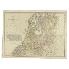
Antique Map of the Low Countries by Ortelius, 1584
About the Item
- Creator:Abraham Ortelius (Artist)
- Dimensions:Height: 16.34 in (41.5 cm)Width: 21.26 in (54 cm)Depth: 0 in (0.01 mm)
- Materials and Techniques:
- Period:
- Date of Manufacture:1584
- Condition:
- Seller Location:Langweer, NL
- Reference Number:
Abraham Ortelius
Abraham Ortelius is widely recognized as the inventor of the atlas and one of the most prominent geographers in history. He is one of the best known and most frequently collected of all sixteenth-century mapmakers, and today, hand-colored, copperplate-printed Abraham Ortelius maps continue to command avid interest.
Ortelius was the eldest of the three children of an Antwerp merchant. After his father's death when he was ten, he was raised by his uncle Jacob Van Meteren — a financier and printer of early English versions of the Bible. Ortelius entered the Guild of Saint Luke in 1547 to become a map copier and colorist, but his hobbies overshadowed his studies.
Ortelius was better known as a student of history and a collector of books and old coins than a cartographer — only initially garnering modest praise for his skills at mapmaking. Gleaning what he learned from his uncle, he became a dealer in books and prints. In 1554 he attended the annual Frankfurt Book Fair, where he met the highly respected cartographer Gerardus Mercator.
Ortelius refocused his work in mapmaking after that fateful encounter. He eventually published Theatrum Orbis Terrarum (Theater of the World) — a comprehensive collection of maps that he bound into a book. It was the first of its kind and is now recognized as the first modern-day atlas. While creating his atlas, Ortelius observed that the coast of America shared geometrical similarities with the shores of Europe and Africa. When he lined up maps of the coastlines of the continents, they matched — much like pieces in a jigsaw puzzle.
Some have argued that the concept of continental drift is at least partly rooted in Ortelius’s 16th-century-era suggestion that the continents had once been joined together as a single mass of land before the Americas were pulled away from Europe and Africa. Much later, in 1912, German meteorologist Alfred Wegener proposed in a lecture and an article that the continents had once been locked together based on data he collected. Wegener was widely ridiculed at the time, but the foundation of modern-day science of plate tectonics has its origins in his work.
On May 18, 2008, a Google Doodle celebrated the 300th anniversary of Ortelius’s atlas.
On 1stDibs, find original Abraham Ortelius prints, landscape prints and more.
- ShippingRetrieving quote...Ships From: Langweer, Netherlands
- Return PolicyA return for this item may be initiated within 14 days of delivery.
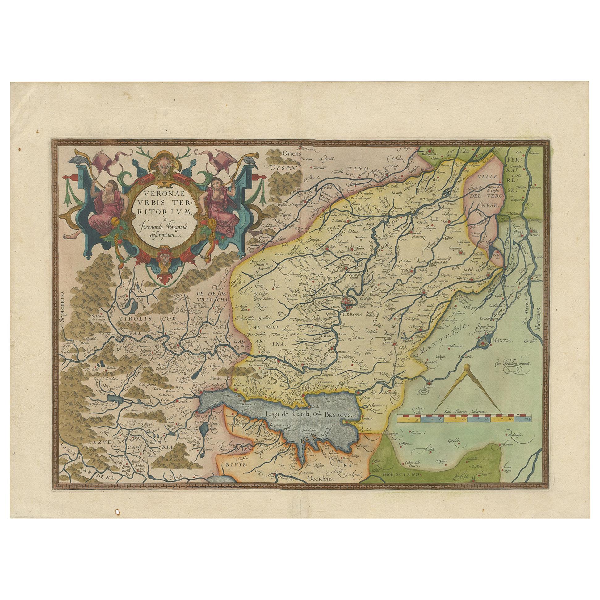
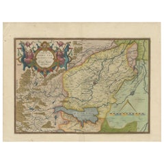
- Antique Map of the Region of Verona 'Italy' by Ortelius, circa 1584Located in Langweer, NLAntique map titled 'Veronae Urbis Terratorium'. Original antique map of the Verona region, Italy. Centered on Verona, and including Mantua, and Lago de Garda. Published by A. Orteliu...Category
Antique Late 19th Century Maps
MaterialsPaper
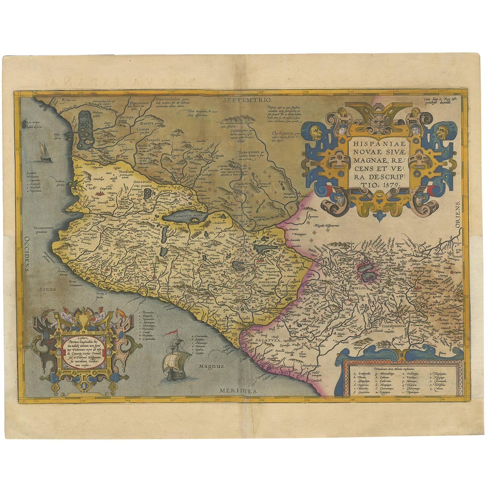
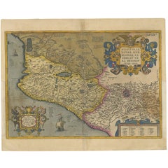
- Antique Map of Mexico by Ortelius, circa 1602By Abraham OrteliusLocated in Langweer, NLAntique map titled 'Hispaniae Novae Sivae Magnae Recens Et Vera Descriptio 1579'. Map of western New Spain, showing the recently-created Spanish settlements, many rivers, and large l...Category
Antique Early 17th Century Belgian Maps
MaterialsPaper
- Antique Map of Southeast Asia by Ortelius '1587'By Abraham OrteliusLocated in Langweer, NLAntique map titled 'Indiae Orientalis Insularumque Adiacientium Typus'. Ortelius includes early European depictions of both Japan and China and is the first to name Formosa (Taiwan). The Philippines and East Indies or Spice Islands are shown based upon Portuguese and Spanish sources, and before their penetration by the Dutch. Japan is shown in kite form, as a large oval island...Category
Antique 16th Century Maps
MaterialsPaper

- Antique Map of the Low Countries by Seutter, c.1745Located in Langweer, NLAntique map titled ‘XVII Provinciae Belgii sive Germaniae Inferioris (..)’. Detailed hand colored map of the Low Countries. Includes colored decorative cartouche, compass rose and co...Category
Antique 18th Century Maps
MaterialsPaper
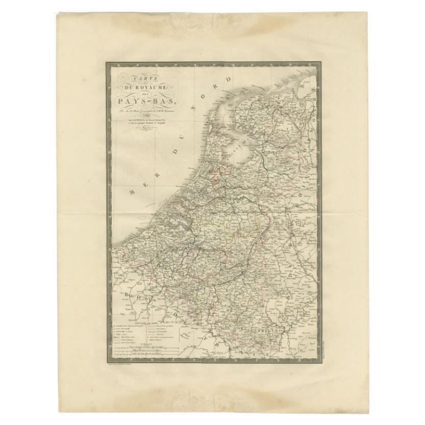
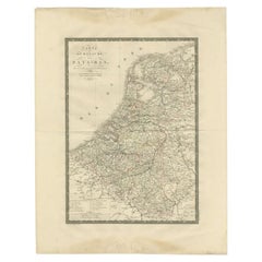
- Antique Map of the Low Countries by Brué, 1822Located in Langweer, NLAntique map titled 'Carte du Royaume des Pays-Bas'. Large format map of the Low Countries. This map originates from 'Atlas Universel', published 1822...Category
Antique 19th Century Maps
MaterialsPaper
- Antique Map of the Low Countries by Cary, 1813Located in Langweer, NLAntique map of the Netherlands titled 'A New Map of the United Provinces comprehending Holland, Zealand, Utrecht, Gelders, Over Yssel, Friesland and Groningen (..)'. Scarce re-editio...Category
Antique 19th Century Maps
MaterialsPaper

- 1861 Topographical Map of the District of Columbia, by Boschke, Antique MapLocated in Colorado Springs, COPresented is an original map of Albert Boschke's extremely sought-after "Topographical Map of the District of Columbia Surveyed in the Years 1856 ...Category
Antique 1860s American Historical Memorabilia
MaterialsPaper
- Gold Leaf Foil Pictorial Plan Map of the West Country of England Antique StyleLocated in GBWe are delighted to offer for sale this lovely Antique style pictorial plan map of the West Country of England etched in gold leaf foil This is a very interesting and decorative p...Category
20th Century English Adam Style Maps
MaterialsGold Leaf
- 1590 Ortelius Map of Calais and Vermandois, France and Vicinity Ric.a014Located in Norton, MA1590 Ortelius map of Calais and Vermandois, France and Vicinity Ric.a014 Two rare regional Abraham Ortelius maps on a single folio sheet. Left map, entitled Caletensium, depic...Category
Antique 16th Century Dutch Maps
MaterialsPaper
- 1592 Abraham Ortelius Map "Lorraine: Lotharingiae Nova Descripti, Ric.A005Located in Norton, MA1592 Abraham Ortelius map entitled "Lorraine: Lotharingiae Nova Descripti Ric.a005 Description: Ortelius is best known for producing the atlas from which this map comes from, "...Category
Antique 16th Century Dutch Maps
MaterialsPaper
- Original Antique Map of The World by Thomas Clerk, 1817Located in St Annes, LancashireGreat map of The Eastern and Western Hemispheres On 2 sheets Copper-plate engraving Drawn and engraved by Thomas Clerk, Edinburgh. Published by Mackenzie And Dent, 1817 ...Category
Antique 1810s English Maps
MaterialsPaper
- 1597 Abraham Ortelius Map Burgundy, France Entitled "Bvrgvndiae dvcatvs Ric.a010Located in Norton, MA1597 Abraham Ortelius map of Burgundy, France entitled "Bvrgvndiae dvcatvs Ric.a010 Description: Ortelius is best known for producing the atla...Category
Antique 16th Century Dutch Maps
MaterialsPaper


