Items Similar to Antique Map of the Region of the Nile River by Bartholomew, 1922


Want more images or videos?
Request additional images or videos from the seller
1 of 5
Antique Map of the Region of the Nile River by Bartholomew, 1922
About the Item
Antique map of Africa titled 'Egypt and the Nile'. Old map of Africa depicting Egypt, the Nile river and surroundings. This map originates from 'The Times' atlas.
Artists and Engravers: John George Bartholomew (22 March 1860 – 14 April 1920) was a British cartographer and geographer. As a holder of a royal warrant, he used the title "Cartographer to the King"; for this reason he was sometimes known by the epithet "the Prince of Cartography". Bartholomew's longest lasting legacy is arguably naming the continent of Antarctica, which until his use of the term in 1890 had been largely ignored due to its lack of resources and harsh climate.
Condition: Very good, please study image carefully.
Date: 1922
Overall size: 45.5 x 59 cm.
Image size: 41.5 x 55 cm.
We sell original antique maps to collectors, historians, educators and interior decorators all over the world. Our collection includes a wide range of authentic antique maps from the 16th to the 20th centuries. Buying and collecting antique maps is a tradition that goes back hundreds of years. Antique maps have proved a richly rewarding investment over the past decade, thanks to a growing appreciation of their unique historical appeal. Today the decorative qualities of antique maps are widely recognized by interior designers who appreciate their beauty and design flexibility. Depending on the individual map, presentation, and context, a rare or antique map can be modern, traditional, abstract, figurative, serious or whimsical. We offer a wide range of authentic antique maps for any budget.
- Dimensions:Height: 23.23 in (59 cm)Width: 17.92 in (45.5 cm)Depth: 0 in (0.01 mm)
- Materials and Techniques:
- Period:
- Date of Manufacture:1922
- Condition:Condition: Very good, please study image carefully.
- Seller Location:Langweer, NL
- Reference Number:
About the Seller
5.0
Platinum Seller
These expertly vetted sellers are 1stDibs' most experienced sellers and are rated highest by our customers.
Established in 2009
1stDibs seller since 2017
1,965 sales on 1stDibs
Typical response time: <1 hour
- ShippingRetrieving quote...Ships From: Langweer, Netherlands
- Return PolicyA return for this item may be initiated within 14 days of delivery.
More From This SellerView All
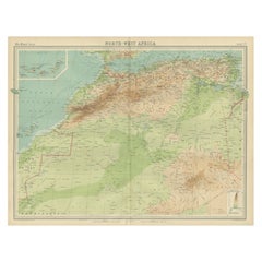
- Antique Map of Northwest Africa by Bartholomew, 1922Located in Langweer, NLAntique map of Africa titled 'North-West Africa'. Old map of north-west Africa depicting Morocco, Algeria, Tunis and surroundings. This map originates from 'The Times' atlas. Artists...Category
20th Century Maps
MaterialsPaper
- Antique Map of Egypt and the Nile RiverLocated in Langweer, NLAntique map titled 'Egypten nach dem Zustand der alten Zeit vorgestellt'. This uncommon and richly detailed map of Egypt features hundreds of place names along the Nile. The Sinai Pe...Category
Antique Mid-18th Century Maps
MaterialsPaper
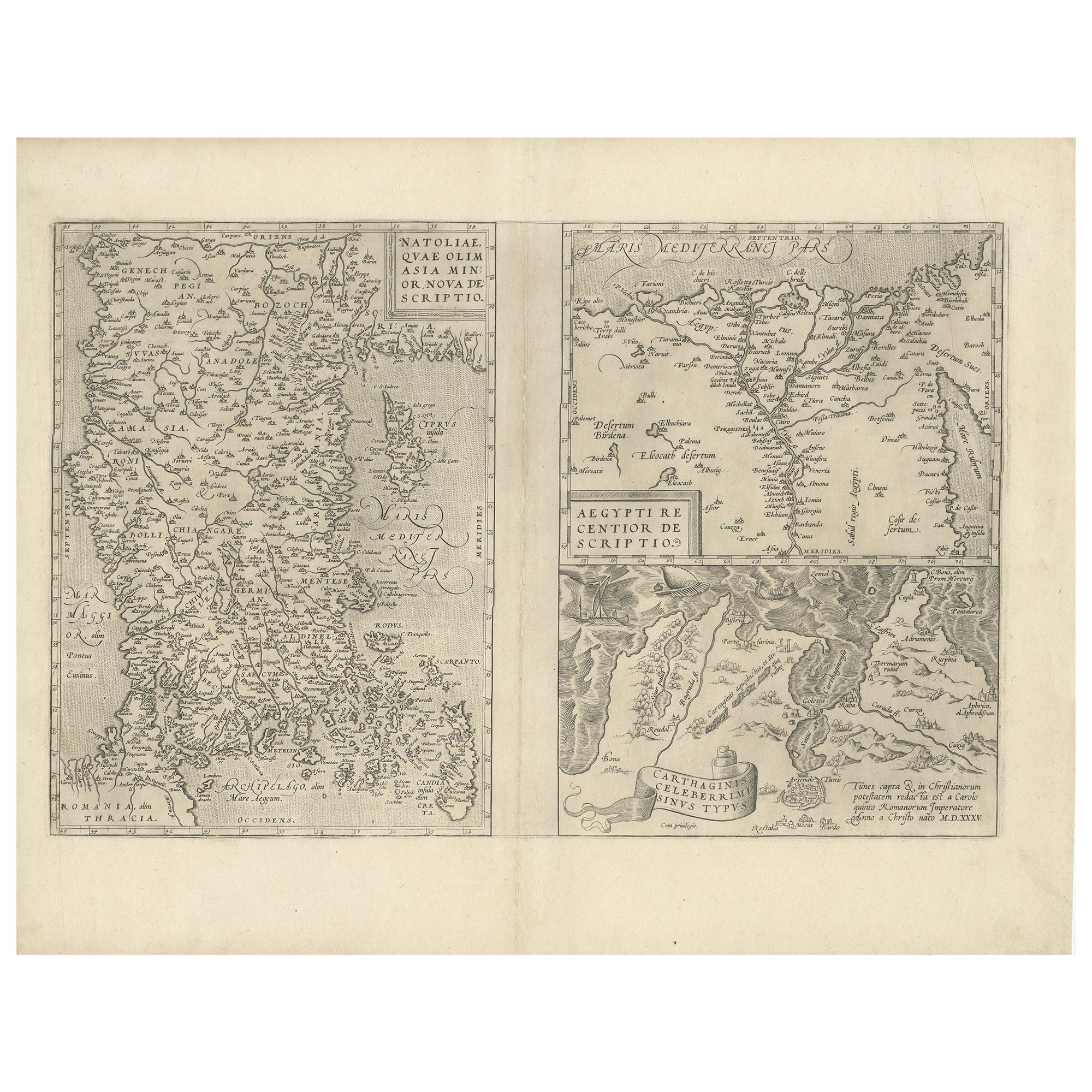
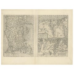
- Antique Map of Asia Minor, Region of the Nile and Region of the City of CarthageLocated in Langweer, NLThree antique maps on one sheet titled 'Natoliae quae olim Asia Minor [with] Aegypti recentior descriptio [with] Carthaginis Celeberrimisinus Typus'. The first map covers Asia Minor,...Category
Antique 16th Century Maps
MaterialsPaper
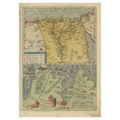
- Antique Map of the Region Around the Nile and the City of CarthageLocated in Langweer, NLAntique map titled 'Aegypti recentior descriptio - Carthaginis Celeberrimi sinus typus'. Two detailed regional maps by Ortelius. One map shows the region around the Nile, as far as A...Category
Antique 16th Century Maps
MaterialsPaper
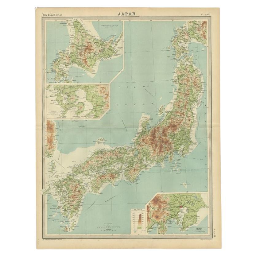
- Antique Map of the Region of Tokyo and Nagasaki in Japan, 1922Located in Langweer, NLAntique map of Japan titled 'Japan - Environs of Tokio & Nagasaki'. Old map of Japan, includes inset maps of Tokyo, Nagasaki and surroundings. This map or...Category
20th Century Maps
MaterialsPaper
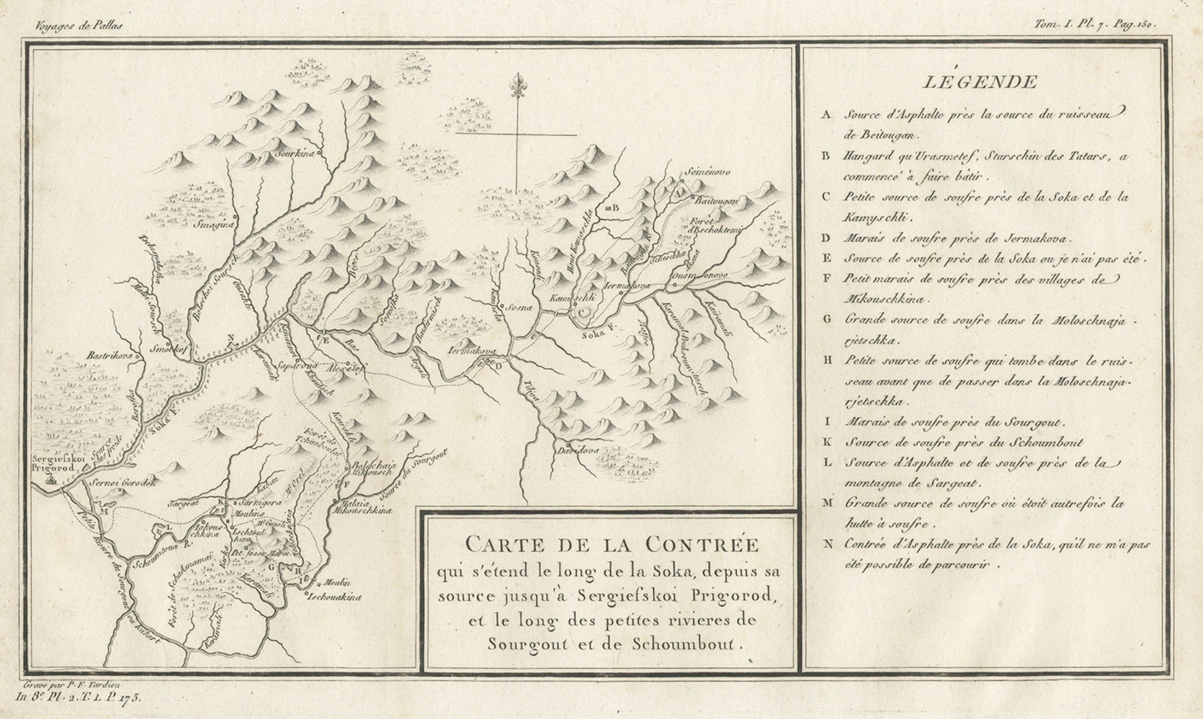
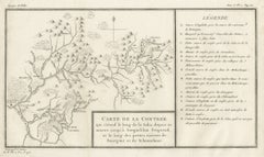
- Antique Map of the Region of the Sok River in Russia, 1794Located in Langweer, NLAntique map titled 'Carte de la Contrée qui s’étend le long de la Soka, depuis sa source jusquá Sergiefskoi Prigorod et le long des petites rivieres de Sourgout et de Schoumbout’. ...Category
Antique 18th Century Maps
MaterialsPaper


You May Also Like
- Antique "New Plan of London" Map by John Bartholomew, 1900Located in Bridgeport, CTProduced for the W.H. Smith guide, folded in the original. The map here is unfolded and framed flat, with transportation routes shown and color details. sight 22 x 32" (original ful...Category
Antique Early 1900s English Victorian Maps
MaterialsPaper
- 1875 "North America" Map by J. BartholomewLocated in Colorado Springs, COPresented is an original 1875 map of “North America.” The map was issued in Volume 1 of the Ninth Edition of the Encyclopædia Britannica, published in Edinburgh. The map was drawn by famous Scottish mapmaker John Bartholomew. The map depicts North America, to include Greenland, the Dominion of Canada, the United States, Mexico, the countries of Central America, and the islands of the West Indies. Prominent rivers, mountain ranges, and cities are labeled on the map, and country borders are emphasized in red. The Encyclopædia Britannica has been published continuously since 1768, appearing in fifteen official editions. The landmark ninth edition of the Encyclopædia Britannica, often called "the Scholar's Edition," was published from January 1875 to 1889 in 25 volumes. The editor and author of the “Foreword” was Thomas Spencer Baynes, the first English-born editor after a series of Scots. After 1880, Baynes was assisted by William Robertson Smith. The 9th edition is often lauded as a high point among early editions for scholarship. The 9th edition was far more luxurious than any previously printed Encyclopædia Britannicas, with thick boards and quality leather bindings, premier paper, and a production which took full advantage of the technological advances of printing in the years between the 1850s and 1870s. The publishers took advantage of the new ability to print large graphic illustrations on the same pages as the text, as opposed to limiting illustrations to separate copper plate engravings. Although this technology had first been used in a primitive fashion the 7th edition, and to a much lesser extent in the 8th, in the 9th edition there were thousands of quality illustrations and maps set...Category
Antique 1870s Scottish Maps
MaterialsPaper
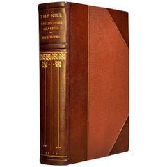
- Emil Ludwig, The Nile, The Life-Story of A RiverLocated in New York, NY1 volume. Illustrated. Bound in 3/4 brown Morocco, cloth boards, top edges gilt, raised bands, gilt spines. Published: New York: The Viking Press, 1937. First Edition. Mea...Category
Vintage 1930s Books
MaterialsLeather
- Antique Oarsman's Map of the River Thames, English, Cartography, Published 1912Located in Hele, Devon, GBThis is an antique copy of The Oarsman's and Angler's Map of the River Thames - New Edition. An English, bound map book, published in English by Edward Stanford, London, this new edi...Category
Early 20th Century British Other Books
MaterialsPaper
- 1861 Topographical Map of the District of Columbia, by Boschke, Antique MapLocated in Colorado Springs, COPresented is an original map of Albert Boschke's extremely sought-after "Topographical Map of the District of Columbia Surveyed in the Years 1856 ...Category
Antique 1860s American Historical Memorabilia
MaterialsPaper
- 1594 Maurice Bouguereau Map of the Region Limoges, France, Ric0015Located in Norton, MA1594 Maurice Bouguereau map of the region Limoges, France, entitled "Totivs Lemovici et Confinium Pro Uinciarum Quantum ad Dioecefin Lemo Uicenfen Fpectant," Hand Colored Ric0015 Jean IV Le Clerc...Category
Antique 16th Century Dutch Maps
MaterialsPaper


Recently Viewed
View AllMore Ways To Browse
1922 Furniture
World Map Vintage Map
World Map Vintage Maps
The World Map Vintage
Map Of World Vintage
Vintage Paper World Map
Antique Egyptian Old
Egypt King
King Of Egypt
Map Egypt Nile
Map Antarctica
Map Holder
Vintage Bartholomew Maps
Vintage Map Holder
Chart Cabinet
Antique Surveying Level
J C Walker Map
Map Of Ancient Greece