Items Similar to Antique Map of the Upper and Lower Rhine by Cary '1811'


Want more images or videos?
Request additional images or videos from the seller
1 of 5
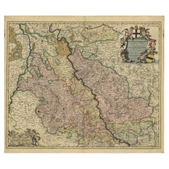
Antique Map of the Upper and Lower Rhine by Cary '1811'
About the Item
Antique map titled 'A New Map of the Circles of the Upper and Lower Rhine'. Antique map covering an area from Westphalia and Lower Saxony in the north to France and Swabia in the south.
- Creator:John Cary (Artist)
- Dimensions:Height: 21.46 in (54.5 cm)Width: 24.81 in (63 cm)Depth: 0.02 in (0.5 mm)
- Materials and Techniques:
- Period:
- Date of Manufacture:1811
- Condition:General age-related toning. Original coloring, please study images carefully.
- Seller Location:Langweer, NL
- Reference Number:

John Cary
John Cary was an English cartographer. He was born in February of 1755 and died in August of 1835. His career started with his apprenticeship in London, and he opened up his own shop in the Strand in 1783. His atlas New and Correct English Atlas became the standard reference work in England. He was commissioned in 1794 by the Postmaster General to survey England's roads. Out of this commission, he published Cary's New Itinerary in 1798. He later produced Ordnance Survey maps before 1805. His business was eventually taken over by G.F. Cruchley.
About the Seller
5.0
Platinum Seller
These expertly vetted sellers are 1stDibs' most experienced sellers and are rated highest by our customers.
Established in 2009
1stDibs seller since 2017
1,966 sales on 1stDibs
Typical response time: <1 hour
- ShippingRetrieving quote...Ships From: Langweer, Netherlands
- Return PolicyA return for this item may be initiated within 14 days of delivery.
More From This SellerView All
- Antique Map of Bavaria and Salzburg by Cary, 1811By John CaryLocated in Langweer, NLAntique map titled 'A New Map of the Circle of Bavaria'. Antique map of Bavaria and Salzburg, Germany. Covers the Duchy of Bavaria and the mountainous A...Category
Antique Early 19th Century Maps
MaterialsPaper
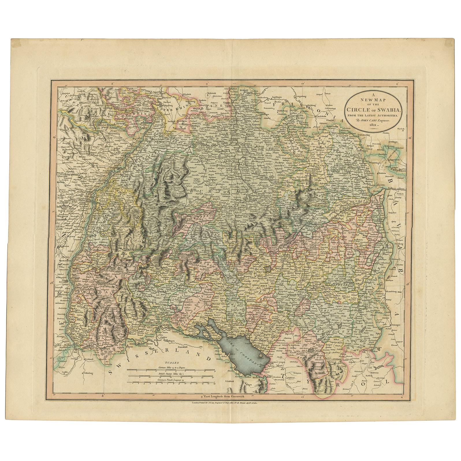
- Antique Map of the Swabia Region of Germany by Cary, '1811'By John CaryLocated in Langweer, NLAntique map titled 'A New Map of the Circle of Swabia'. Antique map of Swabia in Southwestern Germany. Covers from the Upper Rhine region south as far as Switzerland, Lake Constance ...Category
Antique Early 19th Century Maps
MaterialsPaper
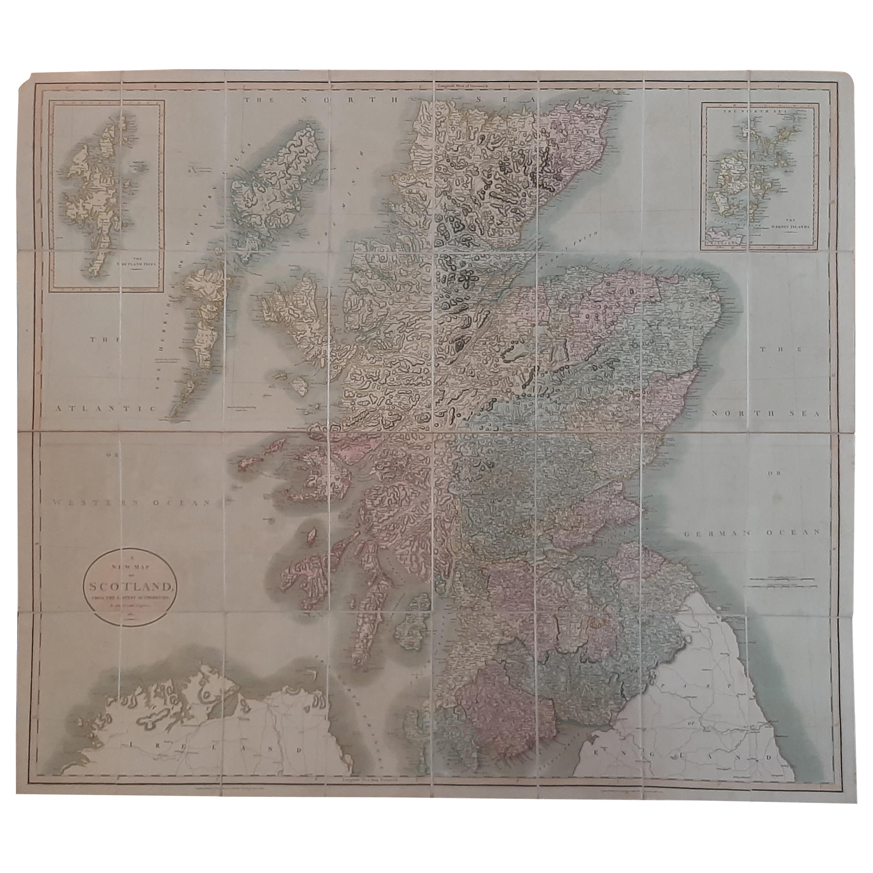
- Antique Map of Scotland by Cary, '1811'Located in Langweer, NLAntique map titled 'A New Map of Scotland from the Latest Authorities': **Title**: A New Map of Scotland from the Latest Authorities **Publisher**: J....Category
Antique Early 19th Century Maps
MaterialsLinen, Paper
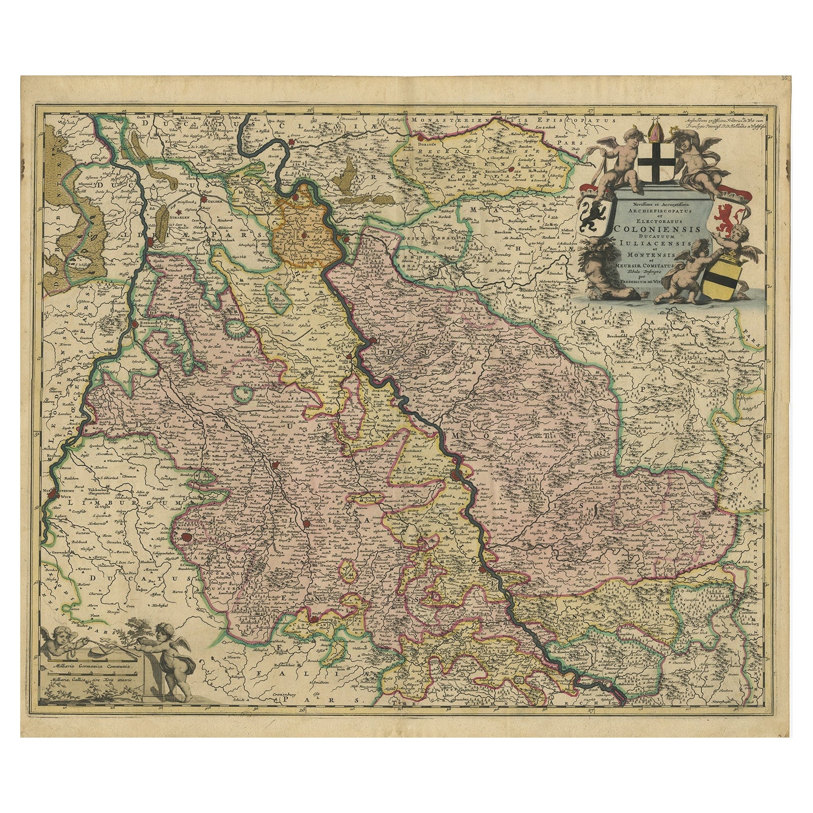
- Rhine Splendor: Antique Map of the Lower Rhine Region, circa 1680Located in Langweer, NLThe antique map titled 'Novissima et Accuratissima Archiepiscopatus et Electoratus Coloniensis Ducatuum Iuliancensis et Montensis et Meursiae Comitatus' is a handsome and detailed ma...Category
Antique 1680s Maps
MaterialsPaper
- Antique Map of Franconia, a region of Germany, '1811'By John CaryLocated in Langweer, NLAntique map titled 'A New Map of the Circle of Franconia'. Detailed map of Franconia in Northwestern Germany. Covers from Upper Saxony south to Swabia, west to the Lower Rhine and we...Category
Antique Early 19th Century Maps
MaterialsPaper
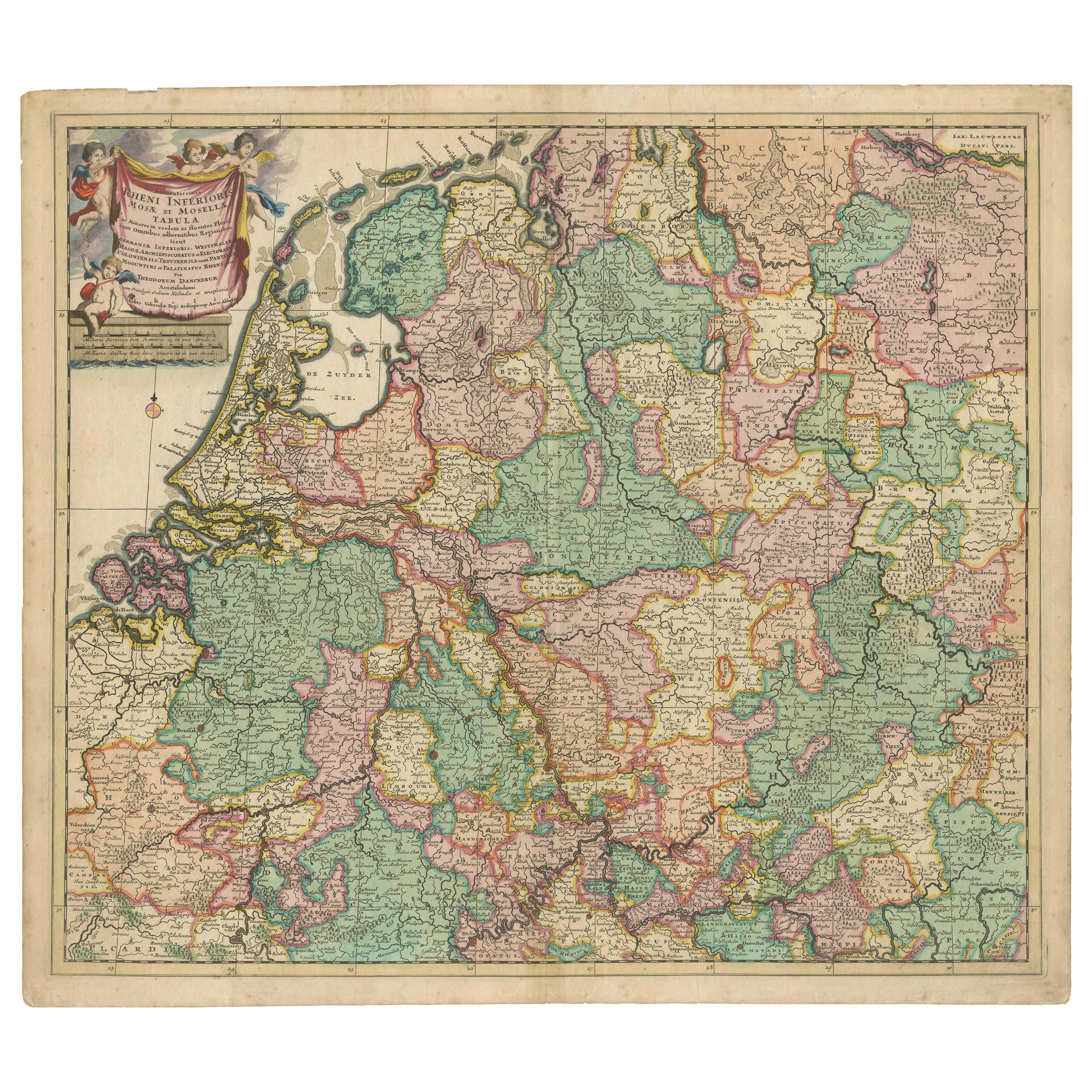
- Rare Theodore Danckerts Map of the Lower Rhine and Moselle River RegionsLocated in Langweer, NLOriginal antique map titled 'Accuratissima Rheni Inferioris Mosae et Mosellae Tabula'. Rare Theodore Danckerts map of the Lower Rhine and Moselle River Regions. The map covers the lo...Category
Antique Early 18th Century Maps
MaterialsPaper


You May Also Like
- "San Francisco, Upper California” 1851 Antique Map of San FranciscoLocated in Colorado Springs, COThis is a pictorial lettersheet view of the city and harbor of San Francisco. This lithograph was printed on grey wove paper, across a double sheet, by famed lithographers Britton & ...Category
Antique 1850s American Prints
MaterialsPaper
- Germany West of the Rhine: A Hand-colored 18th Century Map by de WitBy Frederick de WitLocated in Alamo, CAThis original 18th century hand-colored map of the county of Moers, Germany entitled "Illustrissimo Celsissmo Principi GUILIELMO HENRICO D.G. Arausionum Principi Domino suo Clementis...Category
Antique Early 18th Century Dutch Maps
MaterialsPaper
- Original Antique Map of The World by Thomas Clerk, 1817Located in St Annes, LancashireGreat map of The Eastern and Western Hemispheres On 2 sheets Copper-plate engraving Drawn and engraved by Thomas Clerk, Edinburgh. Published by Mackenzie And Dent, 1817 ...Category
Antique 1810s English Maps
MaterialsPaper
- Extremely Rare Copy of the Venezuelan Declaration of Independance, 1811Located in Amsterdam, NLExtremely rare copy of the Venezuelan Declaration of Independance 'Declaracion de Independencia de las Siete Provincias Unidas de Venezuela en Congreso de 5 de Julio de 1811' By Lorenzo Lüthy (c. 1811-1877), printed in Philadelphia, Peter S. Duval, 1841. Lithograph on laid paper, mounted in passepartout, H. 84 x W. 64.5 cm (with mount H. 96,5 x W. 77 cm.) Large and extremely rare lithographed broadside Declaration of Independence of Venezuela by American immigrant...Category
Antique Early 19th Century Venezuelan Prints
MaterialsPaper
- Original Antique Map of The Netherlands, Engraved by Barlow, Dated 1807Located in St Annes, LancashireGreat map of Netherlands Copper-plate engraving by Barlow Published by Brightly & Kinnersly, Bungay, Suffolk. Dated 1807 Unframed.Category
Antique Early 1800s English Maps
MaterialsPaper
- Map of the Republic of GenoaLocated in New York, NYFramed antique hand-coloured map of the Republic of Genoa including the duchies of Mantua, Modena, and Parma. Europe, late 18th century. Dimension: 25...Category
Antique Late 18th Century European Maps


Recently Viewed
View AllMore Ways To Browse
Map Of South Of France
Antique Map Of The South Of France
Antique French Maps
Antique Map France
Antique Maps France
Antique Map Of France
Antique Maps Of France
Antique Curiosities Prints
Collectible Fair
Dutch Map
Antique Map Engraving
Geographical Map
Germany Map
Map Of Germany
Antique Geography
Antique Old West
Sea Collectables
Antique World Atlas