Items Similar to Antique Map of Zuid-Holland and Utrecht in The Netherlands, 1902

Want more images or videos?
Request additional images or videos from the seller
1 of 6
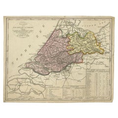
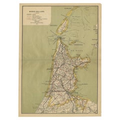
Antique Map of Zuid-Holland and Utrecht in The Netherlands, 1902
About the Item
Antique map titled 'Zuid-Holland en Utrecht'. Lithographed map of the provinces of Zuid-Holland and Utrecht, the Netherlands. This map originates from 'Atlas van Nederland'.
Artists and Engravers: Published by Seyffardt's Boekhandel.
Condition: Fair/good, general age-related toning. Some wear and small marginal tears, Original folding line, with tape on verso. Please study image carefully.
Date: 1902
Overall size: 45 x 32.5 cm.
Image size: 42.5 x 30 cm.
We sell original antique maps to collectors, historians, educators and interior decorators all over the world. Our collection includes a wide range of authentic antique maps from the 16th to the 20th centuries. Buying and collecting antique maps is a tradition that goes back hundreds of years. Antique maps have proved a richly rewarding investment over the past decade, thanks to a growing appreciation of their unique historical appeal. Today the decorative qualities of antique maps are widely recognized by interior designers who appreciate their beauty and design flexibility. Depending on the individual map, presentation, and context, a rare or antique map can be modern, traditional, abstract, figurative, serious or whimsical. We offer a wide range of authentic antique maps for any budget.
- Dimensions:Height: 12.8 in (32.5 cm)Width: 17.72 in (45 cm)Depth: 0 in (0.01 mm)
- Materials and Techniques:
- Period:
- Date of Manufacture:1902
- Condition:Condition: Fair/good, general age-related toning. Some wear and small marginal tears, Original folding line, with tape on verso. Please study image carefully.
- Seller Location:Langweer, NL
- Reference Number:
About the Seller
5.0
Platinum Seller
These expertly vetted sellers are 1stDibs' most experienced sellers and are rated highest by our customers.
Established in 2009
1stDibs seller since 2017
1,967 sales on 1stDibs
Typical response time: <1 hour
- ShippingRetrieving quote...Ships From: Langweer, Netherlands
- Return PolicyA return for this item may be initiated within 14 days of delivery.
More From This SellerView All
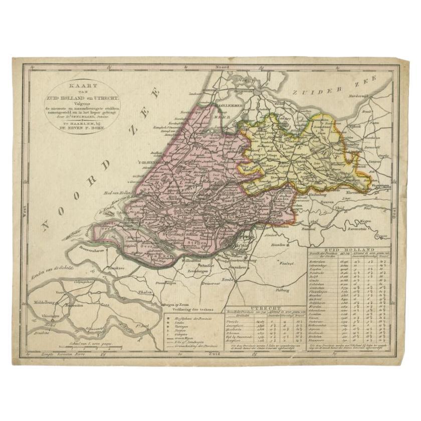
- Antique Map of the Province of Zuid-Holland and Utrecht by Veelwaard, c.1840Located in Langweer, NLAntique map titled 'Kaart van Zuid-Holland en Utrecht (..).' Uncommon map showing the province of Zuid-Holland and Utrecht in the Netherlands. Source unknown, to be determined. Ar...Category
Antique 19th Century Maps
MaterialsPaper
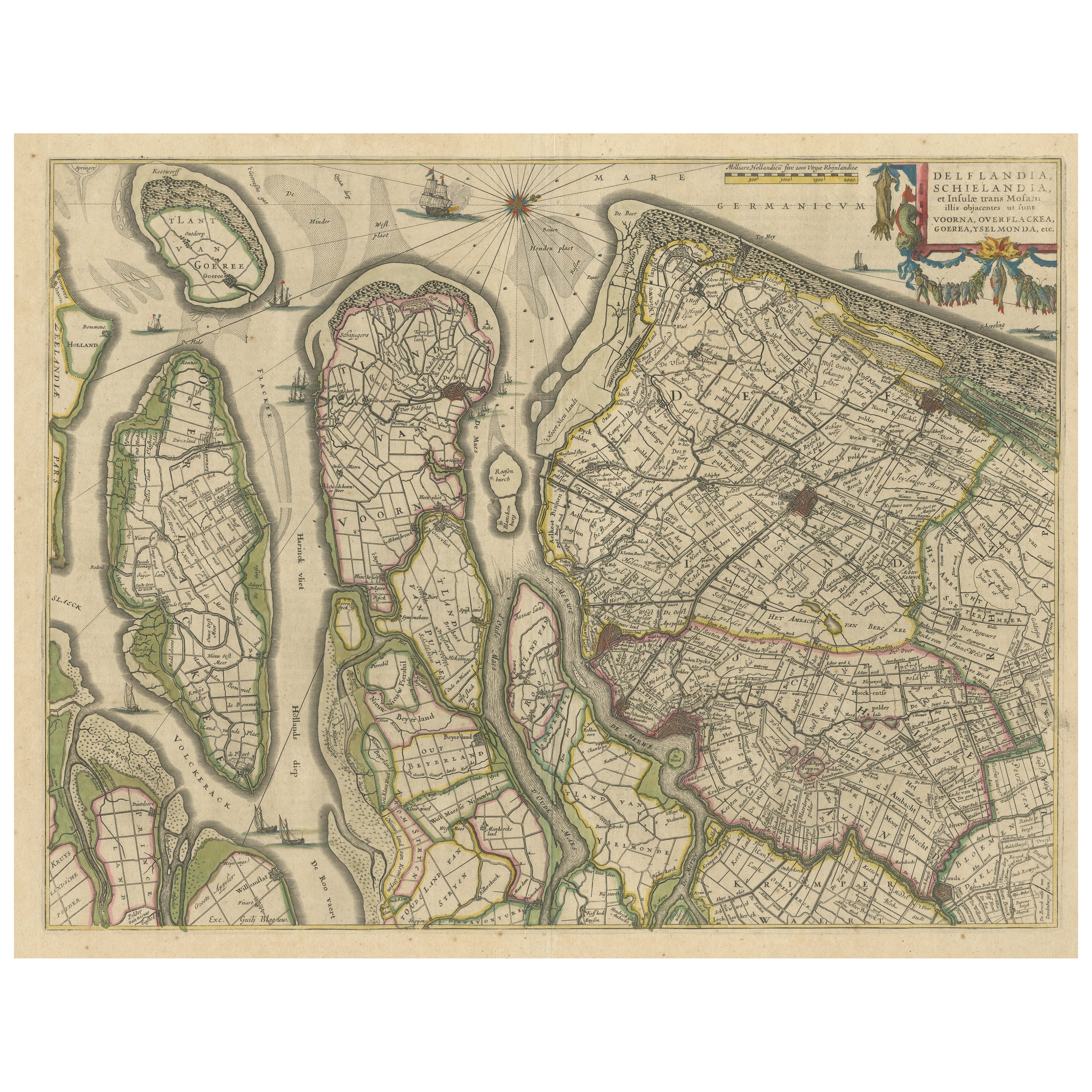
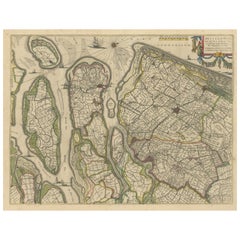
- Antique Map of Delfland, Schieland and Islands of Zuid-Holland, the NetherlandsLocated in Langweer, NLAntique map titled 'Delflandia, Schielandia, et Insulae (..)'. Original antique map of Delfland, Schieland and islands of Zuid-Holland, the Netherlands. The 'Zuid-Hollandse Eilanden'...Category
Antique Mid-17th Century Maps
MaterialsPaper
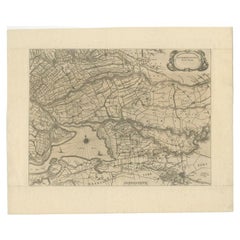
- Original Antique Map of Zuid-Holland in the Netherlands by Blaeu, C.1645Located in Langweer, NLAntique map titled 'Zuydhollandia stricte sumta'. Old map of the province of Zuid-Holland, the Netherlands. This map originates from 'Theatrum Orbis Terrarum (..)'. Artists and E...Category
Antique 17th Century Maps
MaterialsPaper
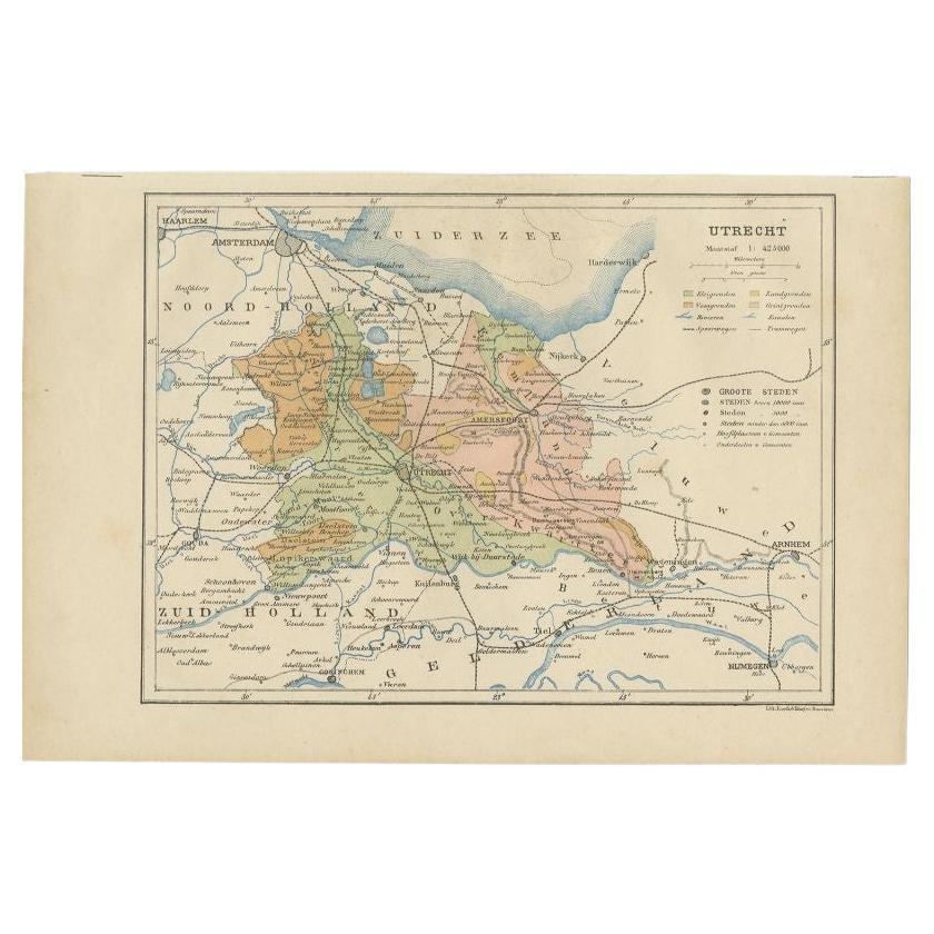
- Antique Map of Utrecht in The Netherlands, 1883Located in Langweer, NLAntique map titled 'Utrecht'. Map of Utrecht, a province of the Netherlands. This map originates from 'Atlas van Nederland volgens de nieuwe spelregels' by J. Kuyper. Artists and En...Category
Antique 19th Century Maps
MaterialsPaper
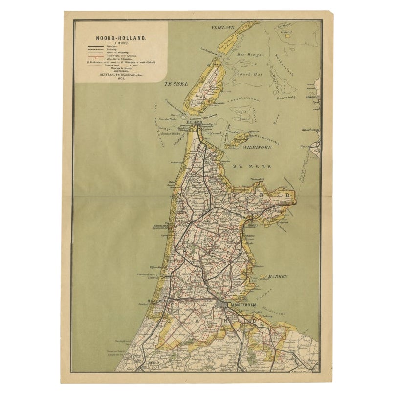
- Antique Map of Noord-Holland, Province of The Netherlands, 1902Located in Langweer, NLAntique map titled 'Noord-Holland'. Lithographed map of the province of Noord-Holland, the Netherlands. This map originates from 'Atlas van Nederland'. Artists and Engravers: Publish...Category
20th Century Maps
MaterialsPaper
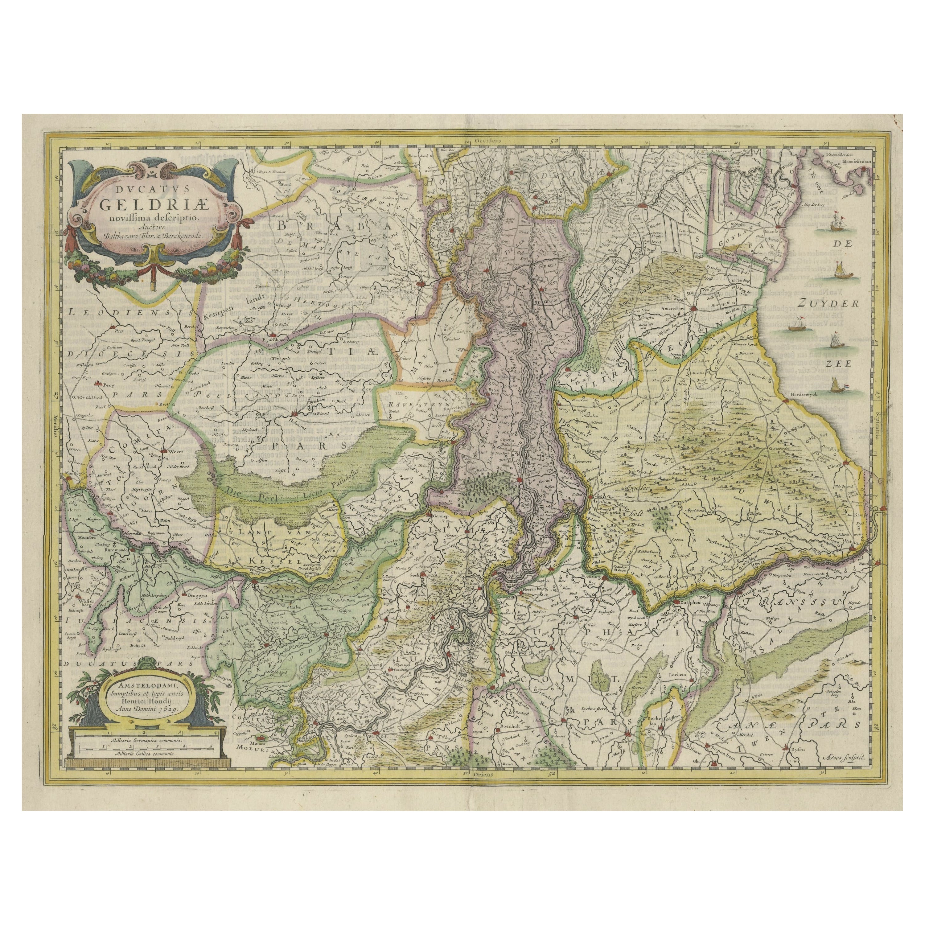
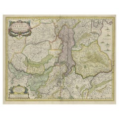
- Original Hand-Colored Antique Map of Gelderland and Utrecht in the NetherlandsLocated in Langweer, NLAntique map titled 'Ducatus Geldriae novissima descriptio'. Detailed map of Gelderland, a province in the Netherlands. Two coats of arms, one with scale. Ships on ‘De Zuyderzee’. Pub...Category
Antique Mid-17th Century Maps
MaterialsPaper

You May Also Like
- Original Antique Map of The Netherlands, Engraved by Barlow, Dated 1807Located in St Annes, LancashireGreat map of Netherlands Copper-plate engraving by Barlow Published by Brightly & Kinnersly, Bungay, Suffolk. Dated 1807 Unframed.Category
Antique Early 1800s English Maps
MaterialsPaper
- 1752 Vaugoundy Map of Flanders : Belgium, France, and the Netherlands, Ric.a002Located in Norton, MALarge Vaugoundy Map of Flanders: Belgium, France, and the Netherlands Colored -1752 Ric.a002 Description: This is a 1752 Didier Robert de Vaugondy map of Flanders. The map de...Category
Antique 17th Century Unknown Maps
MaterialsPaper
- School Chart or Pull Down Map of Geography of the Netherlands, 1950sLocated in Hemiksem, VANA beautiful old school map of the Netherlands, painted on linen. The map shows the 3 different reliefs (low, middle, high) of the Netherlands. The beau...Category
Vintage 1950s Belgian Mid-Century Modern Maps
MaterialsLinen, Paint
- 1861 Topographical Map of the District of Columbia, by Boschke, Antique MapLocated in Colorado Springs, COPresented is an original map of Albert Boschke's extremely sought-after "Topographical Map of the District of Columbia Surveyed in the Years 1856 ...Category
Antique 1860s American Historical Memorabilia
MaterialsPaper
- 1854 Map of Massachusetts, Connecticut and Rhode Island, Antique Wall MapLocated in Colorado Springs, COThis striking wall map was published in 1854 by Ensign, Bridgman & Fanning and has both full original hand-coloring and original hardware. This impression is both informative and highly decorative. The states are divided into counties, outlined in red, green, and black, and subdivided into towns. Roads, canals, and railroad lines are prominently depicted, although they are not all labeled. The mapmakers also marked lighthouses, banks, churches, and prominent buildings, with a key at right. The map is an informative and comprehensive overview of the infrastructural development of New England prior to the Civil War. Physical geographies depicted include elevation, conveyed with hachure marks, rivers and lakes. The impression features an inset map of Boston...Category
Antique 19th Century American Maps
MaterialsPaper
- Original Antique Map of the American State of Oregon, 1889Located in St Annes, LancashireGreat map of Oregon Drawn and Engraved by W. & A.K. Johnston Published By A & C Black, Edinburgh. Original colour Unframed.Category
Antique 1880s Scottish Victorian Maps
MaterialsPaper


Recently Viewed
View AllMore Ways To Browse
1902 Furniture
World Map Vintage Map
World Map Vintage Maps
The World Map Vintage
Map Of World Vintage
Vintage Paper World Map
Holland Utrecht
Vintage Folded Map
Vintage Furniture Utrecht
Zuid Holland
African Money
Antique Hurst
King Charles I Of England
Map Railroad
42 North Antiques
Antique German Compass
Antique Map Box
Antique Map Of Poland