Items Similar to Antique Plan of the City of Grave in Holland With Coats of Arms and Compass Rose


Want more images or videos?
Request additional images or videos from the seller
1 of 6
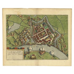
Antique Plan of the City of Grave in Holland With Coats of Arms and Compass Rose
About the Item
Antique map titled 'Grondtekening der Stad Graave'. Plan of Grave, The Netherlands. With coats of arms, compass rose and key. From: Isaak Tirion's 'Hedendaagsche Historie, of Tegenwoordige Staat van alle volken.'
Artists and Engravers: Isaak Tirion, a Dutch publisher in Amsterdam, was born 1705. He produced serveral Atlases and Dutch town plans. The maps mainly based on those of Guillaume de l'Isle. He died in 1765. Tirion was born in Utrecht in 1705. He moved to Amsterdam in 1725 and set up shop on Damrak as a book publisher. Tirion quick rose in prominence by publishing pamphlets, historical works, and, most importantly, maps and atlases. He eventually relocated his printing house to the prestigious Kalverstraat. In his long career he produced eight atlases in multiple editions, some of which were published posthumously until about 1784. Most of his cartographic work is based on the earlier maps of Guillaume de L'Isle.
Condition: Good, given age. Original folds as issued. General age-related toning and/or occasional minor defects from handling. Please study image carefully.
Date: c.1750
Overall size: 23.8 x 19.3 cm.
Image size: 20 x 17 cm.
We sell original antique maps to collectors, historians, educators and interior decorators all over the world. Our collection includes a wide range of authentic antique maps from the 16th to the 20th centuries. Buying and collecting antique maps is a tradition that goes back hundreds of years. Antique maps have proved a richly rewarding investment over the past decade, thanks to a growing appreciation of their unique historical appeal. Today the decorative qualities of antique maps are widely recognized by interior designers who appreciate their beauty and design flexibility. Depending on the individual map, presentation, and context, a rare or antique map can be modern, traditional, abstract, figurative, serious or whimsical. We offer a wide range of authentic antique maps for any budget.
- Creator:Isaak Tirion (Artist)
- Dimensions:Height: 7.6 in (19.3 cm)Width: 9.38 in (23.8 cm)Depth: 0 in (0.01 mm)
- Materials and Techniques:
- Period:
- Date of Manufacture:circa 1750
- Condition:Condition: Good, given age. Original folds as issued. General age-related toning and/or occasional minor defects from handling. Please study image carefully.
- Seller Location:Langweer, NL
- Reference Number:
About the Seller
5.0
Platinum Seller
These expertly vetted sellers are 1stDibs' most experienced sellers and are rated highest by our customers.
Established in 2009
1stDibs seller since 2017
1,967 sales on 1stDibs
Typical response time: <1 hour
- ShippingRetrieving quote...Ships From: Langweer, Netherlands
- Return PolicyA return for this item may be initiated within 14 days of delivery.
More From This SellerView All
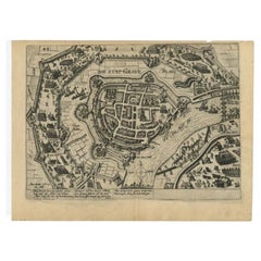
- Antique Plan of Grave, The Netherlands, Showing the Siege of Grave in 1602Located in Langweer, NLAntique map titled 'Die Stat Grave' Bird's eye view plan of Grave, The Netherlands, Holland. Showing the siege of Grave in the year 1602 by Prince Maurits of The Netherlands. Source ...Category
Antique 16th Century Maps
MaterialsPaper
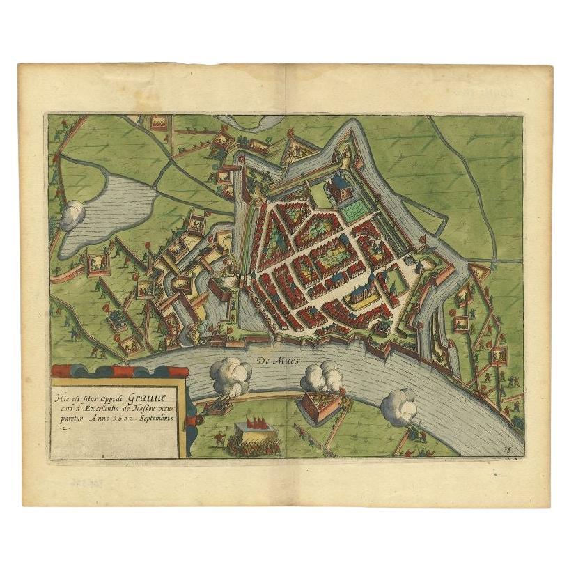
- Antique Plan of the Siege of Grave by Guicciardini, c.1608Located in Langweer, NLAntique map titled 'Hic est situs oppidi Grauiae (..)'. Bird's eye view plan of Grave, The Netherlands, Holland. Showing the siege of Grave in the year 1602. Source unknown, to be de...Category
Antique 17th Century Maps
MaterialsPaper
- Antique Plan of the City of Bayonne, FranceLocated in Langweer, NLAntique map titled 'Plan de Bayonne'. Original old plan of the city of Bayonne, France. This map originates from 'Le Petit Atlas Maritime (..)' by J.N. Bellin. Published 1764. Be...Category
Antique Mid-18th Century Maps
MaterialsPaper
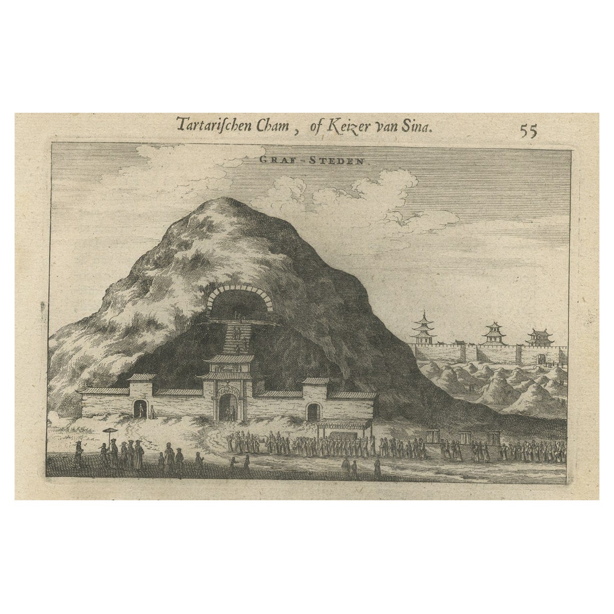
- Antique Print of Graves Near the City of Nanjing in China, 1665Located in Langweer, NLAntique print titled 'Graf-Steden'. Old print depicting graves near the city of Nanjing, China. This print originates from 'Het gezantschap der Nee^rlandtsche Oost-Indische Compagnie...Category
Antique 17th Century Prints
MaterialsPaper
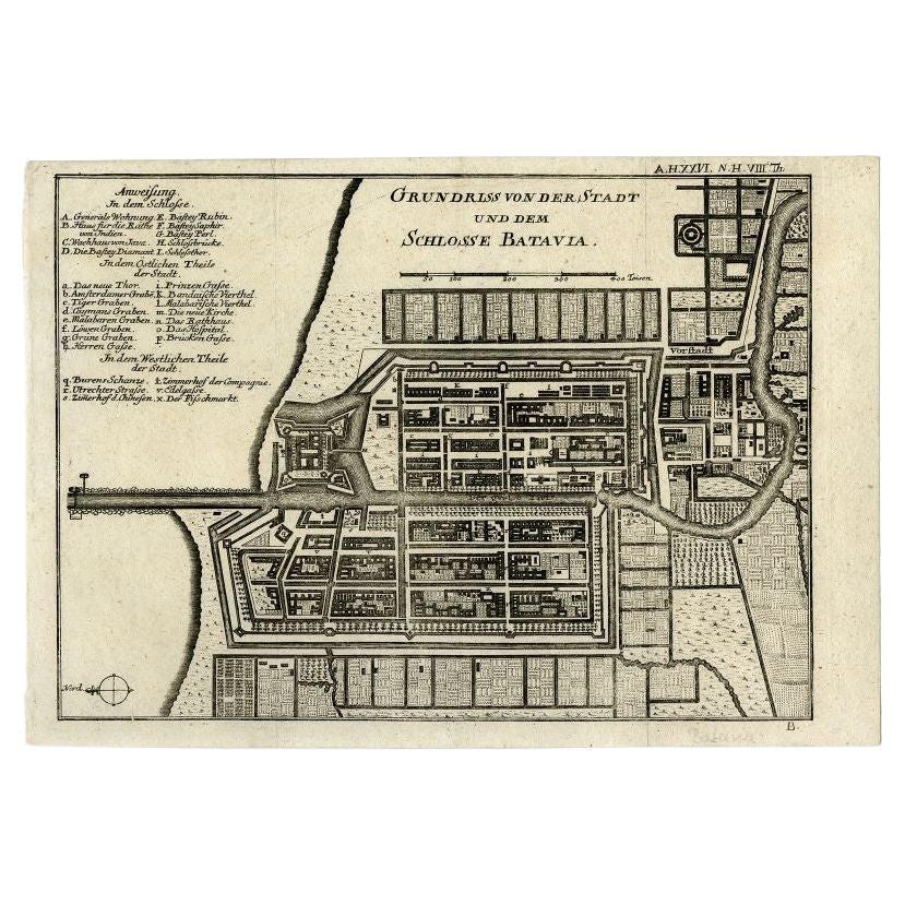
- Antique Plan of Batavia and the Castle in the Dutch East Indies, 1763Located in Langweer, NLAntique map titled 'Grundriss von der Stadt und dem Schlosse Batavia.' Plan of the city and the castle of Batavia in the Dutch East Indies / Indonesia. From 'Algemeine Welthistorie (...Category
Antique 18th Century Maps
MaterialsPaper
- Antique Map of the City of Grave by Blaeu, 1649Located in Langweer, NLAntique map titled 'Grave'. Original antique map of the city of Grave, the Netherlands. Published by J. Blaeu, 1649. Artists and Engravers: Joan Blaeu (23 September 1596 - 28 May...Category
Antique 17th Century Maps
MaterialsPaper


You May Also Like
- Original Antique City Plan of Kansas City, USA. 1894By Rand McNally & Co.Located in St Annes, LancashireFabulous colorful map of Kansas City Original color By Rand, McNally & Co. Published, 1894 Unframed Slightly reduced bottom margin. Free shipping.Category
Antique 1890s American Maps
MaterialsPaper
- Dutch 18th Century Fob seal with coat of armsLocated in Delft, NLDutch 18th Century Fob seal with coat of arms A Dutch 18th Century silver fob seal with coat of arms. A lacquer seal/signet to seal a letter or deed. Signets are wax stamps, also ca...Category
Antique 18th Century Dutch Collectible Jewelry
MaterialsSilver
- Dutch 18th Century Fob seal with coat of armsLocated in Delft, NLDutch 18th Century Fob seal with coat of arms A Dutch 18th Century silver (unmarked) fob seal with coat of arms, probably the Family Van Haenen. In the original leather case. A lacq...Category
Antique 18th Century Dutch Collectible Jewelry
MaterialsSilver
- Original Antique City Plan of Milwaukee, USA, 1894By Rand McNally & Co.Located in St Annes, LancashireFabulous colorful map of Milwaukee Original color By Rand, McNally & Co. Published, 1894 Unframed Free shipping.Category
Antique 1890s American Maps
MaterialsPaper
- Best Planned City in the World: Olmsted, Vaux, and the Buffalo Park SystemLocated in valatie, NYThe Best Planned City in the World: Olmsted, Vaux, and the Buffalo Park System, by Francis R. Kowsky. University of Massachusetts Press, 2013. First edition hardcover with dust jacke...Category
2010s American Books
MaterialsPaper
- Utrecht city planLocated in UTRECHT, UT“Platte grond der Stad Utrecht vertonende alle Gragten, Straaten, Stegen, Gangen, Markten, en plaatsen der openbare Gebouwen”, engraving published by Johannes van Schoonhoven in Amst...Category
Antique 1770s Dutch Other Maps
MaterialsPaper


Recently Viewed
View AllMore Ways To Browse
Antique Coats Of Arms
Antique Compasses
Gravely Furniture
Antique Curiosity Shop
Compass Set
Holland Utrecht
18th Century Server
Antique Compass Set
Set Antique Servers
Antique Server Keys
Antique Caribbean Maps
Antique Furniture Durham
Antique Furniture Tasmania
Antique Maps Caribbean
Large Antique Maps North America
Map Of Peru
Philippines Map
Sri Lanka Map