Items Similar to Charming 18th Century Miniature Map of Greece, 1685


Want more images or videos?
Request additional images or videos from the seller
1 of 5
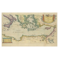
Charming 18th Century Miniature Map of Greece, 1685
About the Item
Antique map titled 'Graeciae Descriptio.' Charming miniature map of Greece from the pocket atlas 'Introductionis in Universam Geographiam tam Veterem quam novam .. Acessit P. Bertii (Bertius) Brevarium Orbis Terrarum', by Ph. Cluverius (Cluver). Artists and Engravers: Petrus Bertius (also Peter Bertius; (Dutch) Pieter de Bert) (14 November 1565 ? 13 October 1629) was a Flemish theologian, historian, geographer and cartographer. Philipp Cluver (1580 - 1622), early modern German geographer and historian.
Artist: Petrus Bertius (also Peter Bertius; (Dutch) Pieter de Bert) (14 November 1565 ? 13 October 1629) was a Flemish theologian, historian, geographer and cartographer. Philipp Cluver (1580 - 1622), early modern German geographer and historian.
Condition: Good, given age. Original folds as issued. General age-related toning and/or occasional minor defects from handling. Please study image carefully.
Date: 1685
Overall size: 14.3 x 13 cm.
Image size: 12.3 x 11.8 cm.
We sell original antique maps to collectors, historians, educators and interior decorators all over the world. Our collection includes a wide range of authentic antique maps from the 16th to the 20th centuries. Buying and collecting antique maps is a tradition that goes back hundreds of years. Antique maps have proved a richly rewarding investment over the past decade, thanks to a growing appreciation of their unique historical appeal. Today the decorative qualities of antique maps are widely recognized by interior designers who appreciate their beauty and design flexibility. Depending on the individual map, presentation, and context, a rare or antique map can be modern, traditional, abstract, figurative, serious or whimsical. We offer a wide range of authentic antique maps for any budget.
- Dimensions:Height: 5.12 in (13 cm)Width: 5.63 in (14.3 cm)Depth: 0 in (0.01 mm)
- Materials and Techniques:
- Period:
- Date of Manufacture:1685
- Condition:
- Seller Location:Langweer, NL
- Reference Number:
About the Seller
5.0
Platinum Seller
These expertly vetted sellers are 1stDibs' most experienced sellers and are rated highest by our customers.
Established in 2009
1stDibs seller since 2017
1,965 sales on 1stDibs
Typical response time: <1 hour
- ShippingRetrieving quote...Ships From: Langweer, Netherlands
- Return PolicyA return for this item may be initiated within 14 days of delivery.
More From This SellerView All
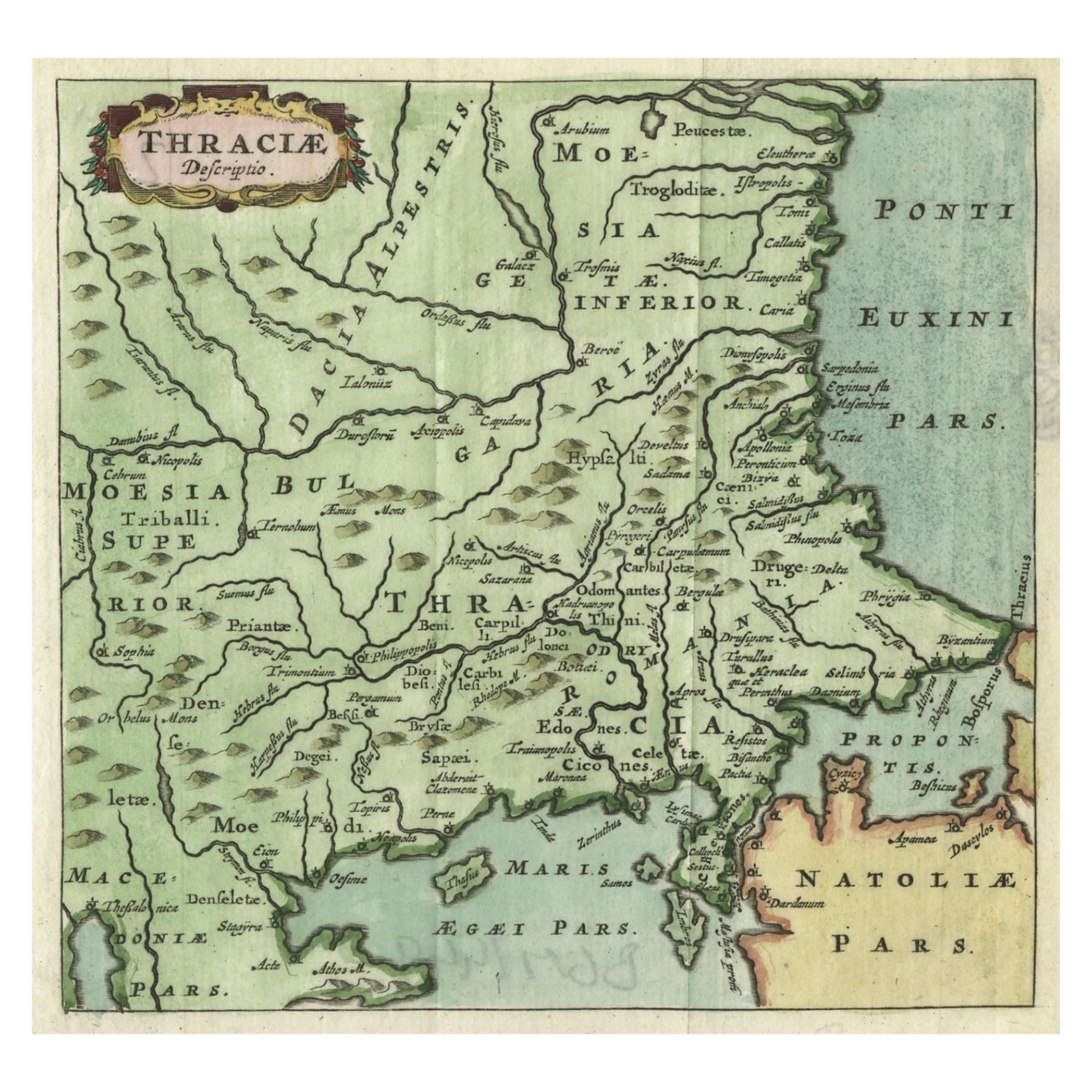
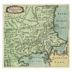
- Charming Miniature Map of Thrace or Thrake in Southeast Europe, 1685Located in Langweer, NLAntique map titled 'Thraciae Descriptio.' Charming miniature map of Thrace, from the pocket atlas 'Introductionis in Universam Geographiam tam Veterem quam novam .. Acessit P. Be...Category
Antique 1680s Maps
MaterialsPaper
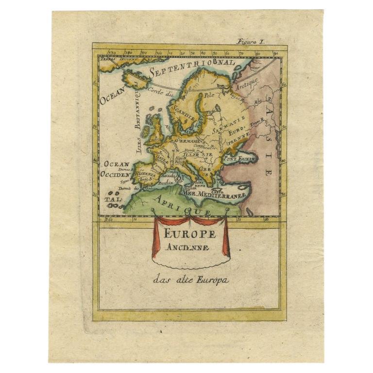
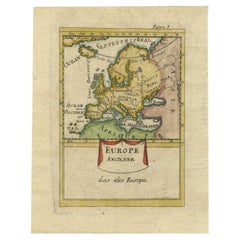
- Antique Hand-Coloured Miniature Map of Ancient Europe, c.1685Located in Langweer, NLAntique map of Europe titled 'Europe Ancienne, Das alte Europa'. Hand-coloured miniature map with much detail. German subtitle. Artists and Engravers: Alain Manneson Mallet (1630-...Category
Antique 17th Century Maps
MaterialsPaper
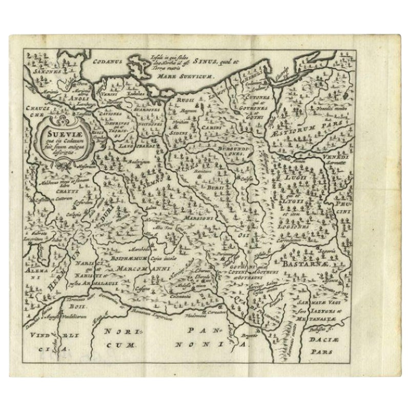
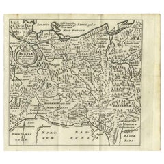
- Antique Map of Swabia, 1685Located in Langweer, NLAntique map titled 'Sueviae quae cis Codanum fuit finum Antiqua defcriptio.' Miniature map of Swabia, a medieval Duchy in south-west Germany, that also included part of Poland, from ...Category
Antique 17th Century Maps
MaterialsPaper
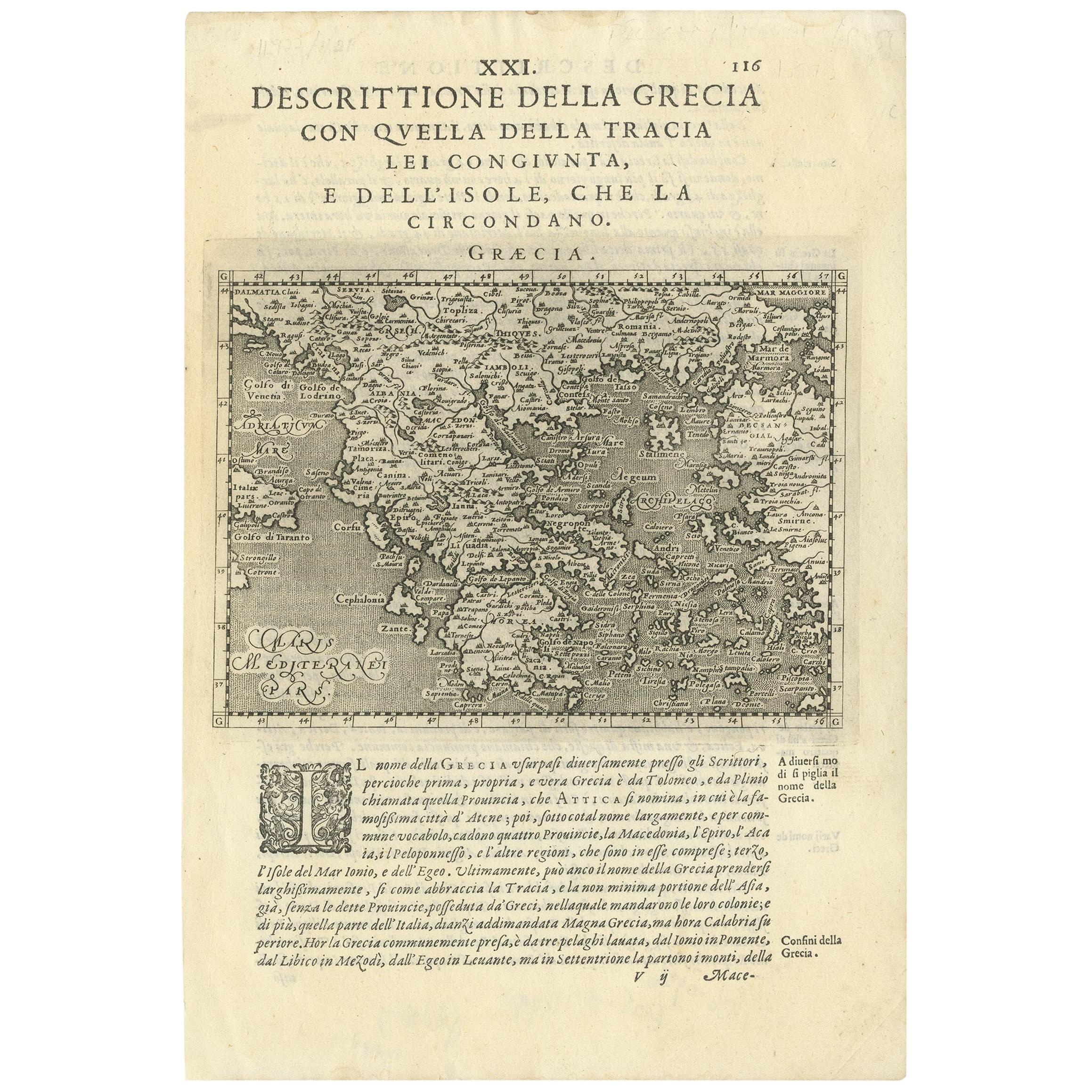
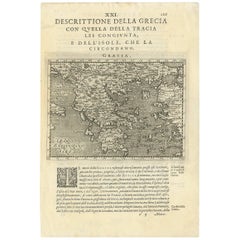
- Rare Original 16th Century Antique Map of Greece, 1598Located in Langweer, NLBeautiful and rare antique map of Greece with Albania, Mecedonia, Romania, Dalmatia and the peninsula of Salento to the Golf of Taranto. Also clearly shown the islands of the Aegaian...Category
Antique 16th Century Maps
MaterialsPaper
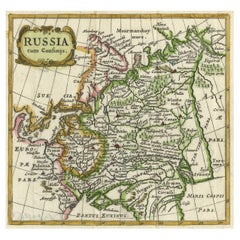
- Charming Decorative Miniature Map of Russia, from an Old Pocket Atlas, 1685Located in Langweer, NLAntique map titled 'Russia cum Consinijs'.' Charming miniature map of Russia, from the pocket atlas 'Introductionis in Universam Geographiam tam Veterem quam novam .. Acessit P. ...Category
Antique 1680s Maps
MaterialsPaper
- Antique Map of the Mediterranean, Telemachus' Journey, Publ. Early 18th CenturyLocated in Langweer, NLTitle: Carte des voyages de Télémaque. Description: Antique map of Telemachus journey, the son of Odysseus and Penelope (Greek mythology ). This map appeared for the first time, e...Category
Antique Early 18th Century Maps
MaterialsPaper
You May Also Like
- Hand-Colored 18th Century Homann Map of the Danube, Italy, Greece, CroatiaBy Johann Baptist HomannLocated in Alamo, CA"Fluviorum in Europa principis Danubii" is a hand colored map of the region about the Danube river created by Johann Baptist Homann (1663-1724) in his 'Atlas Novus Terrarum', publish...Category
Antique Early 18th Century German Maps
MaterialsPaper
- Antique 18th Century Map of the Province of Pensilvania 'Pennsylvania State'Located in Philadelphia, PAA fine antique of the colony of Pennsylvania. Noted at the top of the sheet as a 'Map of the province of Pensilvania'. This undated and anonymous map is thought to be from the Gentleman's Magazine, London, circa 1775, although the general appearance could date it to the 1760's. The southern boundary reflects the Mason-Dixon survey (1768), the western boundary is placed just west of Pittsburgh, and the northern boundary is not marked. The map has a number of reference points that likely refer to companion text and appear to be connected to boundaries. The western and southern boundaries are marked Q, R, S, for example. A diagonal line runs from the Susquehanna R to the Lake Erie P. A broken line marked by many letters A, B, N, O, etc., appears in the east. There are no latitude or longitude markings, blank verso. Framed in a shaped contemporary gilt wooden frame and matted under a cream colored matte. Bearing an old Graham Arader Gallery...Category
Antique 18th Century British American Colonial Maps
MaterialsPaper
- Scandinavia & Portions of Eastern Europe: 18th Century Hand-Colored Homann MapBy Johann Baptist HomannLocated in Alamo, CAAn early 18th century hand-colored copper-plate map entitled "Regni Sueciae in omnes suas Subjacentes Provincias accurate divisi Tabula Generalis" by Johann Baptist Homann (1663-1724...Category
Antique Early 18th Century German Maps
MaterialsPaper
- 18th Century Hand Colored Map of Spain and Portugal by VisscherBy Nicolaes Visscher IILocated in Alamo, CAThis is an early 18th century map of Spain and Portugal, with attractive original hand-coloring, entitled "Hispaniae et Portugalliae Regna per Nicolaum Visscher cum Privilegio Ordinu...Category
Antique Early 18th Century Dutch Maps
MaterialsPaper
- 18th Century Hand-Colored Homann Map of Germany, Including Frankfurt and BerlinBy Johann Baptist HomannLocated in Alamo, CAAn 18th century hand-colored map entitled "Tabula Marchionatus Brandenburgici et Ducatus Pomeraniae quae sunt Pars Septentrionalis Circuli Saxoniae Superioris" by Johann Baptist Homa...Category
Antique Early 18th Century German Maps
MaterialsPaper
- West Coast of Africa, Guinea & Sierra Leone: An 18th Century Map by BellinBy Jacques-Nicolas BellinLocated in Alamo, CAJacques Bellin's copper-plate map entitled "Partie de la Coste de Guinee Dupuis la Riviere de Sierra Leona Jusquau Cap das Palmas", depicting the coast of Guinea and Sierra Leone in ...Category
Antique Mid-18th Century French Maps
MaterialsPaper


Recently Viewed
View AllMore Ways To Browse
Miniature Maps
Antique Map Greece
Antique Maps Of Greece
A Tam
Blaeu Maps
Large Antique City Maps
Map Blaeu
Used Office Furniture Edinburgh
Map Of United Kingdom
Antique Map Blaeu
Great Britain Maps
Atlas Book
19th Century Africa Collectibles
Dutch Empire
Hand Carved Wooden Ships
Antique Compass Rose
Compass Rose Antique
Framed Map United States