Items Similar to Interesting Original Antique Map of South America, 1822


Want more images or videos?
Request additional images or videos from the seller
1 of 5
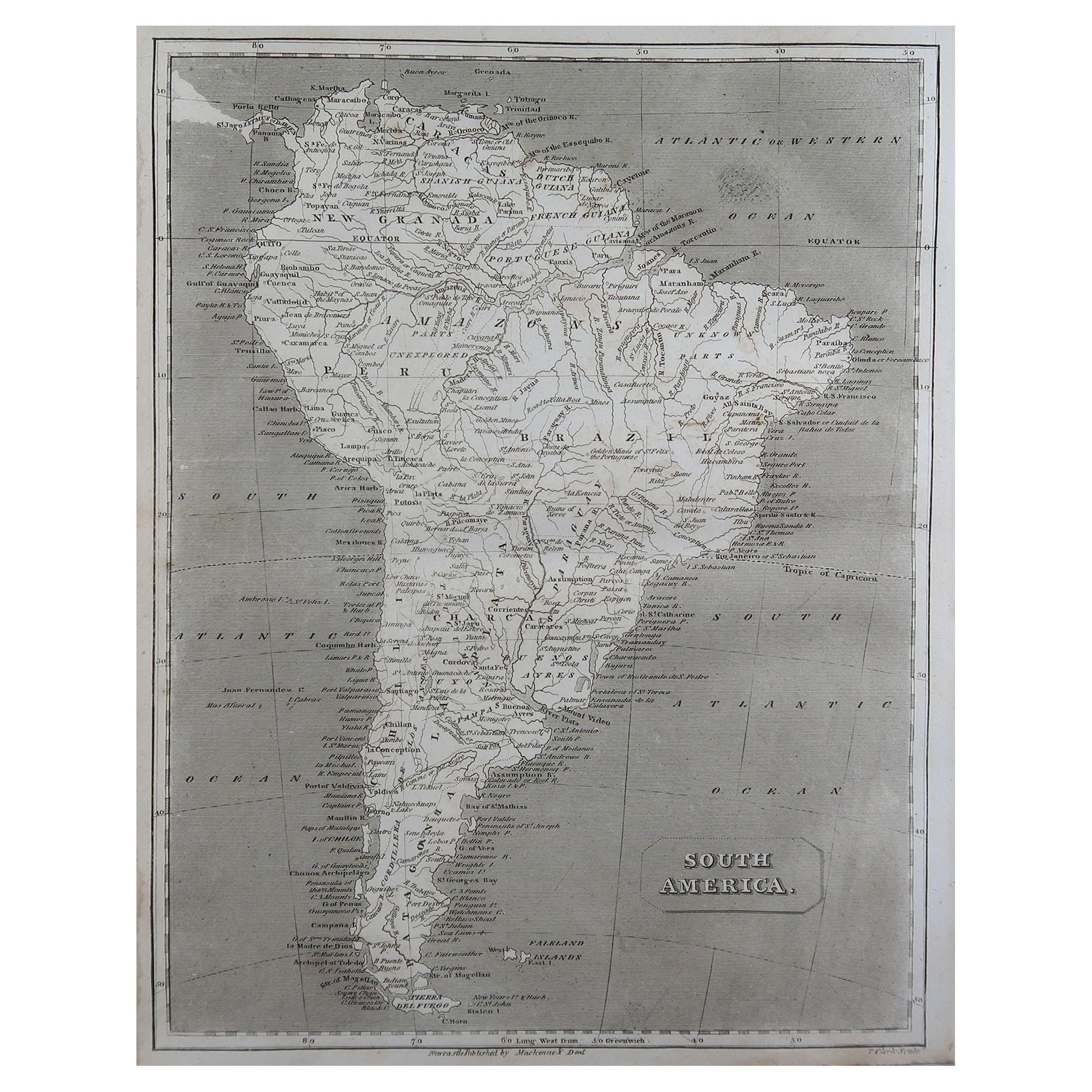
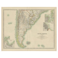
Interesting Original Antique Map of South America, 1822
About the Item
Antique map titled 'South America'.
Map of South America with attractive topography, surrounded on three sides by text on the history, geography, and economy of the continent. Shows a huge La Plata province that includes much of Peru and all of present-day Bolivia and Argentina north of Patagonia. This map originates from 'A Complete Historical, Chronological, And Geographical American Atlas, Being A Guide To The History Of North And South America, And The West Indies ... To The Year 1822'. Artists and Engravers: Author: H.C. Carey.
Artist: Author: H.C. Carey.
Condition: Good, general age-related toning. Stains in upper part of the map, please study image carefully.
Date: 1822
Overall size: 56.5 x 45 cm.
Image size: 0.001 x 31 x 42 cm.
Antique prints have long been appreciated for both their aesthetic and investment value. They were the product of engraved, etched or lithographed plates. These plates were handmade out of wood or metal, which required an incredible level of skill, patience and craftsmanship. Whether you have a house with Victorian furniture or more contemporary decor an old engraving can enhance your living space. We offer a wide range of authentic antique prints for any budget.
- Dimensions:Height: 17.72 in (45 cm)Width: 22.25 in (56.5 cm)Depth: 0 in (0.01 mm)
- Materials and Techniques:
- Period:
- Date of Manufacture:1822
- Condition:Condition: Good, general age-related toning. Stains in upper part of the map, please study image carefully.
- Seller Location:Langweer, NL
- Reference Number:Seller: BG-006621stDibs: LU3054327620662
About the Seller
5.0
Platinum Seller
These expertly vetted sellers are 1stDibs' most experienced sellers and are rated highest by our customers.
Established in 2009
1stDibs seller since 2017
1,965 sales on 1stDibs
Typical response time: <1 hour
- ShippingRetrieving quote...Ships From: Langweer, Netherlands
- Return PolicyA return for this item may be initiated within 14 days of delivery.
Auctions on 1stDibs
Our timed auctions are an opportunity to bid on extraordinary design. We do not charge a Buyer's Premium and shipping is facilitated by 1stDibs and/or the seller. Plus, all auction purchases are covered by our comprehensive Buyer Protection. Learn More
More From This SellerView All
- Original Antique Map of Peru in South America, 1875Located in Langweer, NLAntique map titled 'Carte générale du Pérou'. Large map of Peru. This map originates from 'Atlas de Géographie Moderne Physique et Politique' by A. Levasse...Category
Antique Late 19th Century Maps
MaterialsPaper
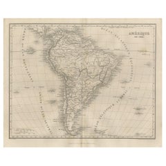
- Scarce Antique Map of South AmericaLocated in Langweer, NLAntique map titled 'Carte de l'Amérique Méridionale'. Scarce map of South America, published in Paris in 1821. The map shows the continent in the ...Category
Antique Early 19th Century Maps
MaterialsPaper
- Antique Map of South America by G. Anson, 1749Located in Langweer, NLAntique map titled 'Kaart van het Zuidelykste Gedeelte van Zuider Amerika (..) - Carte de la Partie Meridionale de l'Amerique Meridionale (..)'. Detailed chart tracking the route of Capt. George Anson's ship The Centurion in 1745. The chart shows the tracks of Anson's ships around South America & Cape Horn to the Juan Fernandes Islands, with notes on currents and positions. This map originates from 'Reize rondsom de Werreld (..)' by George Anson, published 1749. In 1740 Capt. George Anson (1697-1762) of the Royal Navy, was given command of a squadron of ships. As England was at war with France and Spain, Anson's task was to intercept and capture a Spanish treasure...Category
Antique Mid-18th Century Dutch Maps
MaterialsPaper
- Antique Map of South America by Lowry, 1852Located in Langweer, NLAntique map titled 'South America'. Original map of South America. This map originates from 'Lowry's Table Atlas constructed and engraved from the most recent authorities' by J.W. Lo...Category
Antique Mid-19th Century Maps
MaterialsPaper
- Antique Map of South America by Johnston '1909'Located in Langweer, NLAntique map titled 'South America, Southern Sheet'. Depicting Chile, Argentina, Brazil, Patagonia, the Falkland Island and more. With inset maps of Valparaiso, Rio de Janeiro and Bue...Category
Early 20th Century Maps
MaterialsPaper
- Antique Map of South America by Balbi '1847'Located in Langweer, NLAntique map titled 'Amérique du sud'. Original antique map of South America. This map originates from 'Abrégé de Géographie (..)' by Adrie...Category
Antique Mid-19th Century Maps
MaterialsPaper


You May Also Like
- Large Antique 1859 Map of North AmericaLocated in Sag Harbor, NYThis Map was made by Augustus Mitchell in 1859 It is in amazing condition for being 163 years old. This price is for the rolled up easy to ship version of this piece. I will be Frami...Category
Antique Mid-19th Century American Maps
MaterialsCanvas, Paper

- South America: Hand-colored 18th Century Framed Map by Thomas JefferysBy Thomas JefferysLocated in Alamo, CAThis detailed hand-colored map of South America by Thomas Jefferys was published in London in 1750. The map shows countries, early colonial possessions, towns, rivers, mountains, and...Category
Antique Mid-18th Century English Maps
MaterialsPaper
- North & South America: A 17th Century Hand-colored Map by Jansson & GoosBy Johannes JanssoniusLocated in Alamo, CAA 17th century hand-colored map of North & South America entitled "Americae Descriptio" by the cartographer Johannes Jansson, published in Jansson's Atlas Minor in Amsterdam in 1628....Category
Antique 1620s Dutch Maps
MaterialsPaper
- Antique Map of Principality of MonacoBy Antonio Vallardi EditoreLocated in Alessandria, PiemonteST/619 - "Old Geographical Atlas of Italy - Topographic map of ex-Principality of Monaco" - ediz Vallardi - Milano - A somewhat special edition ---Category
Antique Late 19th Century Italian Other Prints
MaterialsPaper
- Antique Map of South America in Roma FrameLocated in Malibu, CAAntique map of South America. Displayed in a new Roma frame with museum quality matting. Custom frame in platinum. No print date, but cert...Category
Antique Late 19th Century Victorian Prints
MaterialsHardwood, Paper
- New Map of North America from the Latest Discoveries, 1763Located in Philadelphia, PAA fine antique 18th century map of the North American seaboard. Entitled "A New Map of North America from the Latest Discoveries 1763". By the Cartographer/Engraver - John Spil...Category
Antique Mid-18th Century English Georgian Maps
MaterialsPaper


Recently Viewed
View AllMore Ways To Browse
Map Of South America
Old American Maps
Antique Furniture Peru
Peruvian Antiques
Victorian American West
19th Century Peruvian
Peruvian Handmade
Map Of West Indies
West Indies Map
Antique Map Of The West Indies
Antique Maps West Indies
West Indies Antique Map
42 North Antiques
Map Of Peru
Peru Map
Antique Map Peru
Old Patagonia
Antique Map Of Argentina