Items Similar to Antique Map of the Duchies of Bremen and Verden by Homann, c.1730

Want more images or videos?
Request additional images or videos from the seller
1 of 5
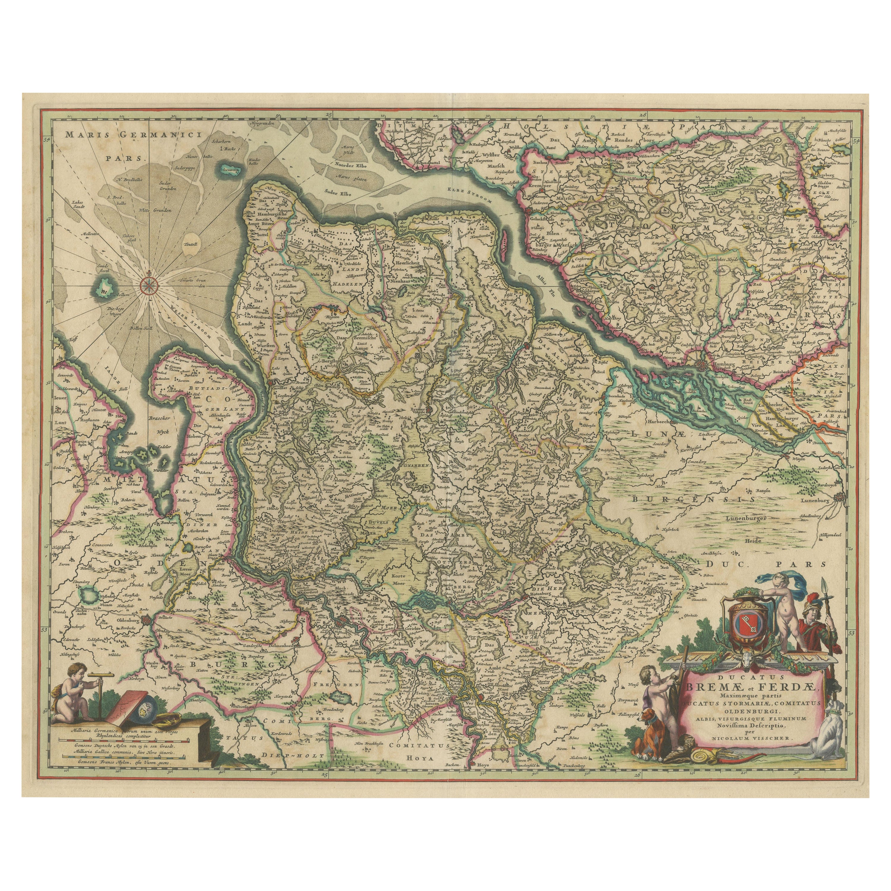
Antique Map of the Duchies of Bremen and Verden by Homann, c.1730
About the Item
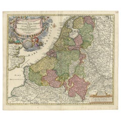
Antique map titled 'Ducatus Bremae et Ferdae (..)'. Map of the Duchies of Bremen and Verden, Germany. Source unknown, to be determined.
Artists and Engravers: Johann Baptist Homann (1663-1724) was a mapmaker who founded the famous Homann Heirs publishing company. He lived his entire life in Bavaria, particularly in Nuremberg.
Condition: Fair/good, general age-related toning. Repair on folding line. Minor wear and soiling, blank verso. Please study image carefully.
Date: c.1730
Overall size: 60 x 53 cm.
Image size: 57 x 49 cm.
We sell original antique maps to collectors, historians, educators and interior decorators all over the world. Our collection includes a wide range of authentic antique maps from the 16th to the 20th centuries. Buying and collecting antique maps is a tradition that goes back hundreds of years. Antique maps have proved a richly rewarding investment over the past decade, thanks to a growing appreciation of their unique historical appeal. Today the decorative qualities of antique maps are widely recognized by interior designers who appreciate their beauty and design flexibility. Depending on the individual map, presentation, and context, a rare or antique map can be modern, traditional, abstract, figurative, serious or whimsical. We offer a wide range of authentic antique maps for any budget.
- Creator:Johann Baptist Homann (Artist)
- Dimensions:Height: 20.87 in (53 cm)Width: 23.63 in (60 cm)Depth: 0 in (0.01 mm)
- Materials and Techniques:
- Period:
- Date of Manufacture:circa 1730
- Condition:
- Seller Location:Langweer, NL
- Reference Number:

Johann Baptist Homann
Johann Baptist Homann (1663-1724) was a mapmaker who founded a respected and prolific publishing company, which continued long after his death as Homann Heirs. Homann lived his entire life in Bavaria, particularly in Nuremberg. Initially, Johann trained to become a priest before converting to Protestantism and working as a notary. In 1702, Johann founded a publishing house that specialized in engravings. The firm flourished, becoming the leading map publisher in Germany and an important entity in the European map market. In 1715, Johann was named Imperial Geographer to the Holy Roman Empire by Charles VI and made a member of the Prussian Academy of Sciences. Most importantly for his business, his reputation and contacts gained him imperial printing privileges which protected his publications and recommended him to customers.
About the Seller
5.0
Platinum Seller
These expertly vetted sellers are 1stDibs' most experienced sellers and are rated highest by our customers.
Established in 2009
1stDibs seller since 2017
1,966 sales on 1stDibs
Typical response time: <1 hour
- ShippingRetrieving quote...Ships From: Langweer, Netherlands
- Return PolicyA return for this item may be initiated within 14 days of delivery.
More From This SellerView All
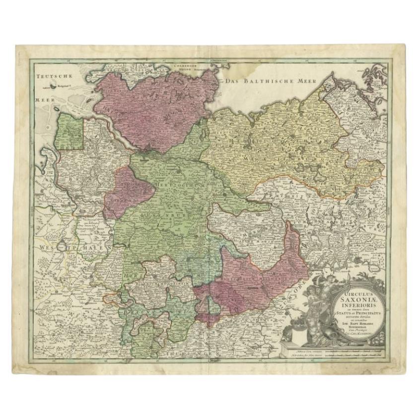
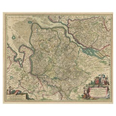
- Antique Map of the Lower Saxony Region by Homann, c.1730By Johann Baptist HomannLocated in Langweer, NLAntique map titled 'Circulus Saxoniae Inferioris (..)'. Map of the Circle of Lower Saxony. The map covers most of present-day northern Germany, as far south as Göttingen, including m...Category
Antique 18th Century Maps
MaterialsPaper
- Antique Map of the region of Bremen and Verden, GermanyLocated in Langweer, NLAntique map titled 'Ducatus Bremae et Ferdae (..)'. Original antique map of the region of Bremen and Verden, Germany. Published by N. Visscher, circa 1690. The Visscher family were...Category
Antique Late 17th Century Maps
MaterialsPaper
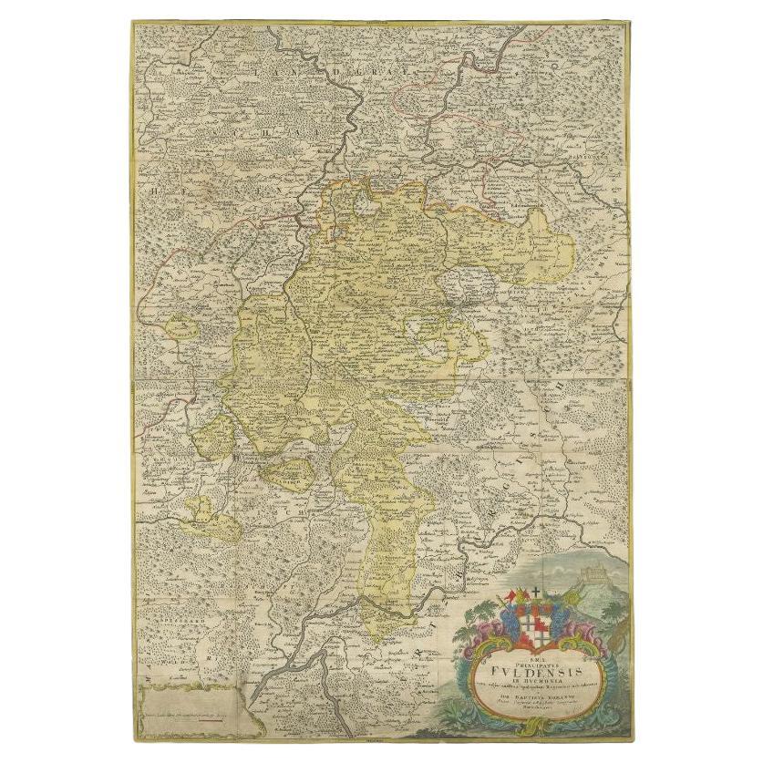
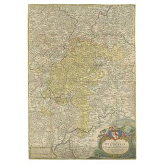
- Antique Map of the Region of Fulda by Homann, c.1730Located in Langweer, NLAntique map titled 'S.R.I. Principatus Fuldensis in Buchonia'. Rare edition of the large JB Homann map of the principality of Fulda, Germany. Artists and Engravers: Johann Baptist...Category
Antique 18th Century Maps
MaterialsPaper
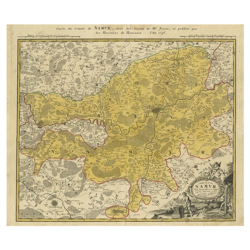
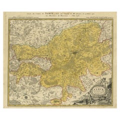
- Antique Map of the Region of Namen by Homann, 1746By Johann Baptist HomannLocated in Langweer, NLAntique map titled 'Comitatus Namur Tabula Geographica ex mappis Frixianis'. Regional map of Namen, Belgium. Artists and Engravers: Homann Heirs was a German publishing firm tha...Category
Antique 18th Century Maps
MaterialsPaper
- Antique Map of Sweden by Homann, 'circa 1730'Located in Langweer, NLAntique map titled 'Nova Tabula Scaniae (..)'. Attractive map showing the historical provinces of Sweden: Schonen with Malmö, Blekinge with Karlskrona and the south part of Halland. ...Category
Antique Mid-18th Century Maps
MaterialsPaper
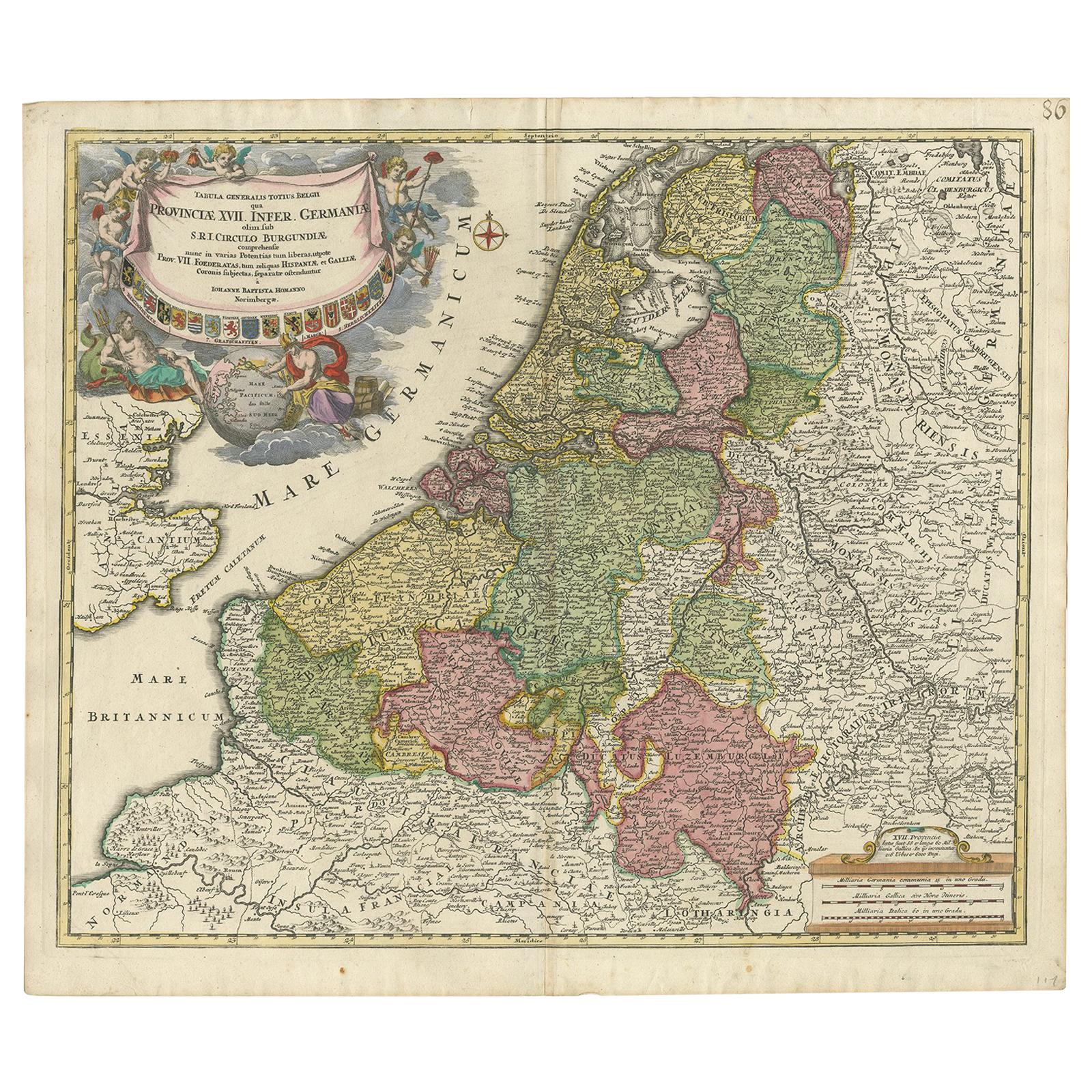
- Antique Map of the Netherlands and Belgium by Homann, circa 1710By Johann Baptist HomannLocated in Langweer, NLAntique map titled 'Tabula Generalis Totius Belgii Provinciae XVII. Infer. Germaniae (..)'. Map of the Benelux countries by Johann Baptist Homann. Shows the area between the Seine es...Category
Antique Early 18th Century German Maps
MaterialsPaper


You May Also Like
- The Kingdom of Naples and Southern Italy: A Hand-Colored 18th Century Homann MapBy Johann Baptist HomannLocated in Alamo, CA"Novissima & exactissimus Totius Regni Neapolis Tabula Presentis Belli Satui Accommo Data" is a hand colored map of southern Italy and the ancient Kingdom of Naples created by Johann...Category
Antique Early 18th Century German Maps
MaterialsPaper
- Hand Colored 18th Century Homann Map of Austria Including Vienna and the DanubeBy Johann Baptist HomannLocated in Alamo, CA"Archiducatus Austriae inferioris" is a hand colored map of Austria created by Johann Baptist Homann (1663-1724) and published in Nuremberg, Germany in 1728 shortly after his death. ...Category
Antique Early 18th Century German Maps
MaterialsPaper
- Hand-Colored 18th Century Homann Map of Denmark and Islands in the Baltic SeaBy Johann Baptist HomannLocated in Alamo, CAAn 18th century copper plate hand-colored map entitled "Insulae Danicae in Mari Balthico Sitae utpote Zeelandia, Fionia, Langelandia, Lalandia, Falstria, Fembria Mona" created by Joh...Category
Antique Early 18th Century German Maps
MaterialsPaper
- Hand-Colored 18th Century Homann Map of the Black Sea, Turkey and Asia MinorBy Johann Baptist HomannLocated in Alamo, CAAn attractive original early 18th century hand-colored map of the Black Sea and Turkey entitled "Carte de L'Asie Minevre ou de la Natolie et du Pont Evxin Tiree des Voyages et des Ob...Category
Antique Early 18th Century German Maps
MaterialsPaper
- Hand-Colored 18th Century Homann Map of the Danube, Italy, Greece, CroatiaBy Johann Baptist HomannLocated in Alamo, CA"Fluviorum in Europa principis Danubii" is a hand colored map of the region about the Danube river created by Johann Baptist Homann (1663-1724) in his 'Atlas Novus Terrarum', publish...Category
Antique Early 18th Century German Maps
MaterialsPaper
- Sweden & Adjacent Portions of Scandinavia: A Hand-Colored 18th C. Map by HomannBy Johann Baptist HomannLocated in Alamo, CAThis hand-colored map of Sweden and adjacent portions of Scandinavia entitled "Regni Sueciae in Omnes suas Subjacentes Provincias accurate divisi Tabula Generalis" was created by Joh...Category
Antique 1720s German Maps
MaterialsPaper


Recently Viewed
View AllMore Ways To Browse
Antique Bavaria
Antique Map Bremen
Antique Nautical Map
Antique Nautical Maps
Map Of Arabia
Antique Stand Up Scale
Civil War Map
Antique Furniture Cyprus
Antique Linen Map
Antique Nautical Charts
British Isles Antique Map
Georgia Map
Map Of West Indies
Scottish Coat Of Arms
Speed Map
West Indies Map
Antique Map Of South Africa
Antique Railroad Collectables