Items Similar to Antique Map of the Kingdom of Sweden by Güssefeld, 1793


Want more images or videos?
Request additional images or videos from the seller
1 of 5
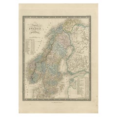
Antique Map of the Kingdom of Sweden by Güssefeld, 1793
About the Item
Antique map titled 'Charte über das Konigreich Schweden (..)'. Original antique map of the Kingdom of Sweden. Source unknown, to be determined.
Artists and Engravers: Franz Ludwig Güssefeld (6 December 1744 – 17 June 1807) was a German cartographer. He is noted for his highly accurate maps which were mostly published by Homannsche Erben ("Homann Heirs") in Nuremberg.
Condition: Fair, age-related toning. Original folding line (with split). Some wear and small defects. Blank verso, please study image carefully.
Date: 1793
Overall size: 54 x 65 cm.
Image size: 45 x 58.5 cm.
We sell original antique maps to collectors, historians, educators and interior decorators all over the world. Our collection includes a wide range of authentic antique maps from the 16th to the 20th centuries. Buying and collecting antique maps is a tradition that goes back hundreds of years. Antique maps have proved a richly rewarding investment over the past decade, thanks to a growing appreciation of their unique historical appeal. Today the decorative qualities of antique maps are widely recognized by interior designers who appreciate their beauty and design flexibility. Depending on the individual map, presentation, and context, a rare or antique map can be modern, traditional, abstract, figurative, serious or whimsical. We offer a wide range of authentic antique maps for any budget.
- Dimensions:Height: 25.6 in (65 cm)Width: 21.26 in (54 cm)Depth: 0 in (0.01 mm)
- Materials and Techniques:
- Period:
- Date of Manufacture:1793
- Condition:
- Seller Location:Langweer, NL
- Reference Number:
About the Seller
5.0
Platinum Seller
These expertly vetted sellers are 1stDibs' most experienced sellers and are rated highest by our customers.
Established in 2009
1stDibs seller since 2017
1,960 sales on 1stDibs
Typical response time: <1 hour
- ShippingRetrieving quote...Ships From: Langweer, Netherlands
- Return PolicyA return for this item may be initiated within 14 days of delivery.
More From This SellerView All
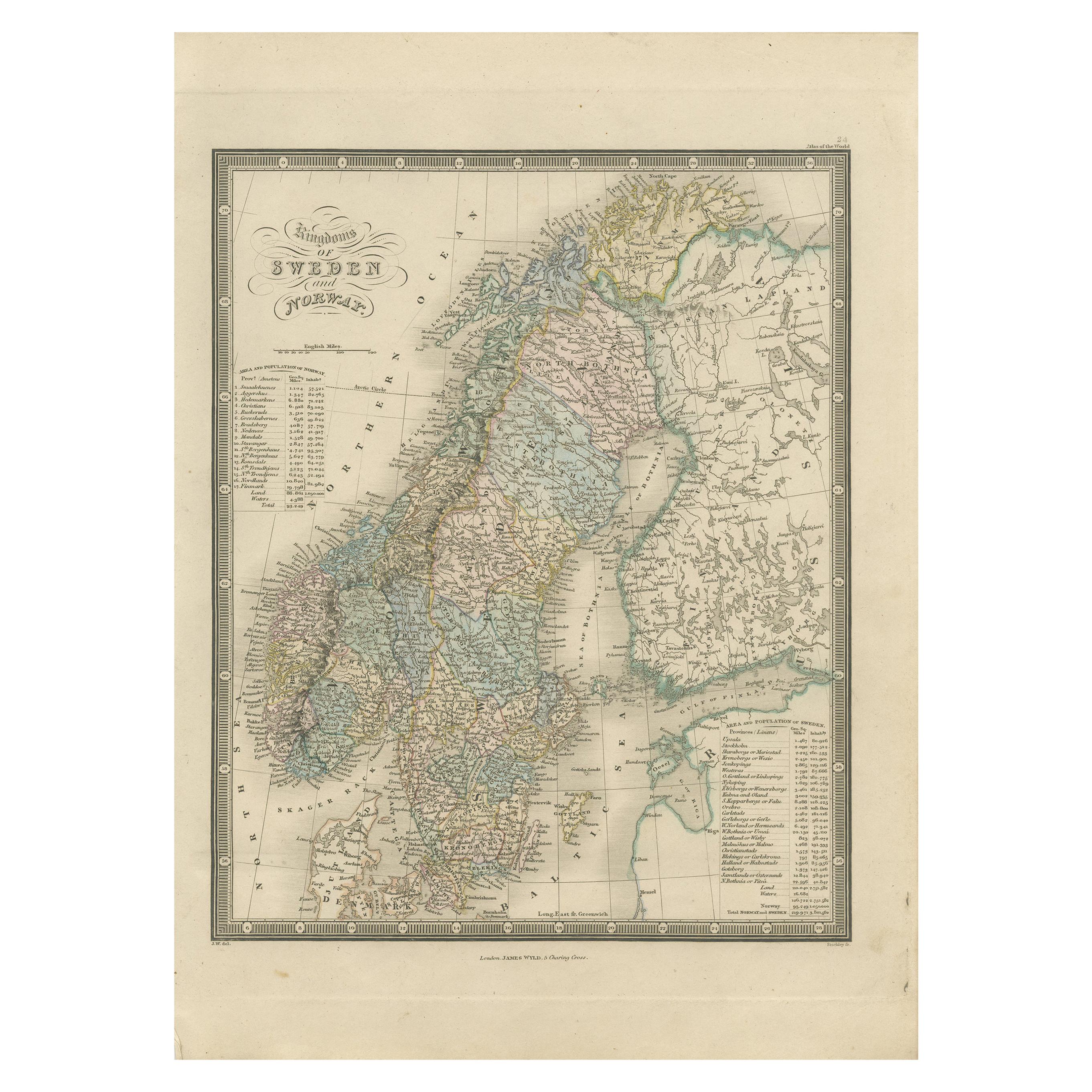
- Antique Map of the Kingdoms of Sweden and Norway by Wyld '1845'Located in Langweer, NLAntique map titled 'Kingdoms of Sweden and Norway'. Original antique map of the Kingdoms of Sweden and Norway. This map originates from 'An Atlas of the World, Comprehending Separate...Category
Antique Mid-19th Century Maps
MaterialsPaper
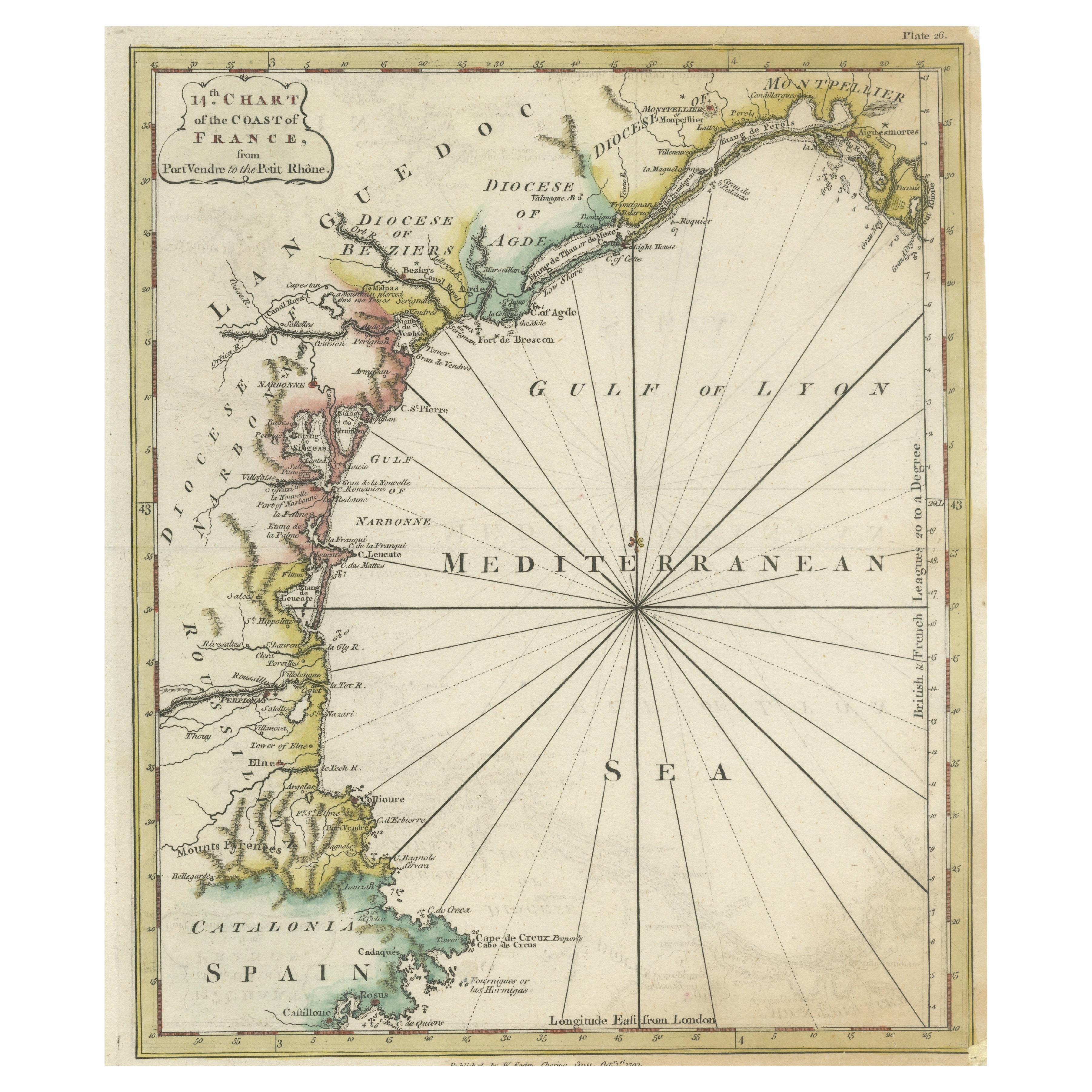
- Antique Map of the Coast of Southern France, 1793Located in Langweer, NLAntique map titled '14th Chart of the Coast of France, from Port Vendres to the Petit Rhône'. Original map with later hand coroling of the coast of Southern France. This map originat...Category
Antique Late 18th Century Maps
MaterialsPaper
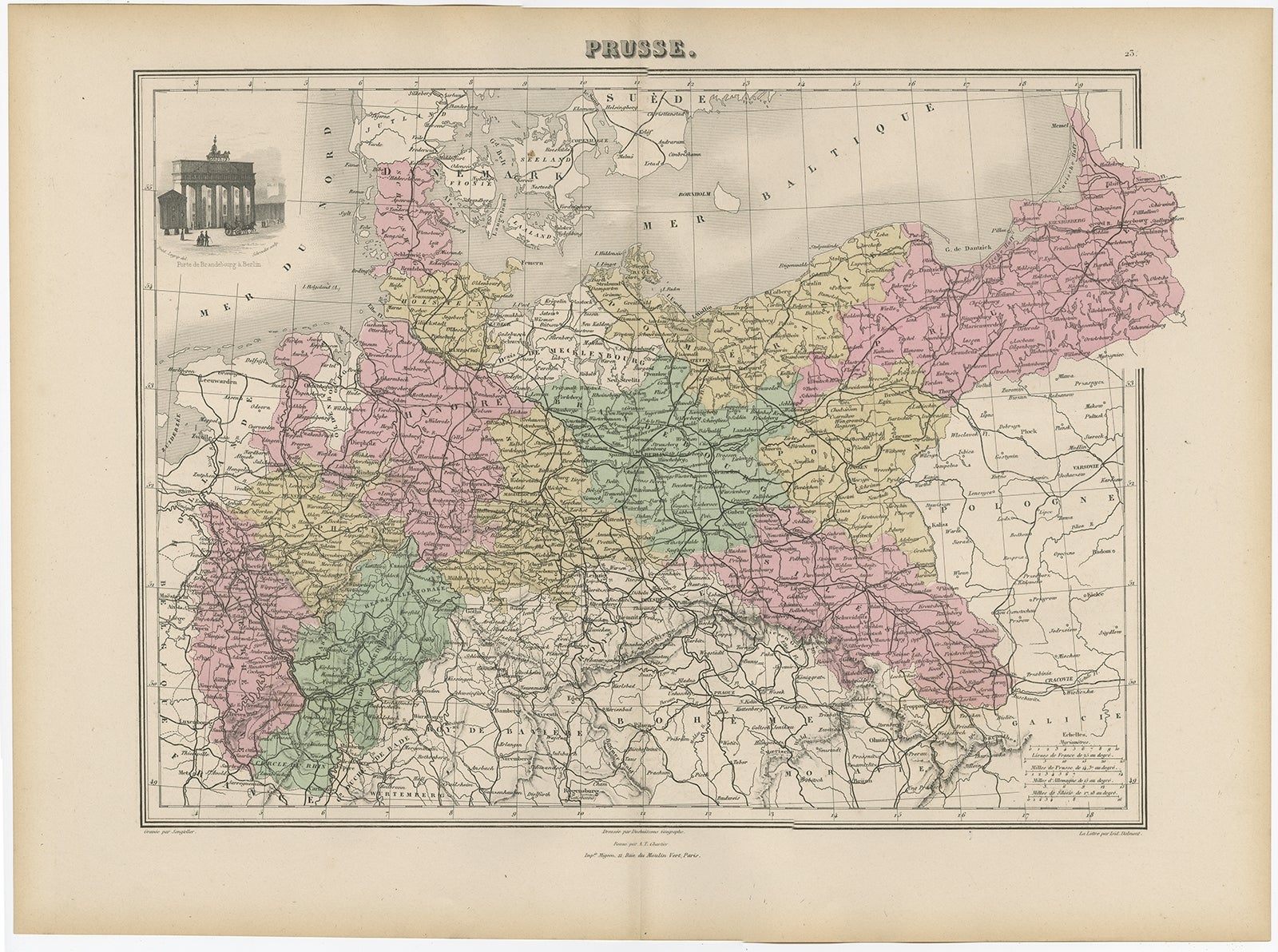
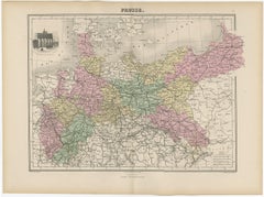
- Antique Map of the Kingdom of Prussia, 1880Located in Langweer, NLAntique map titled 'Prusse'. Old map of the Kingdom of Prussia, with a decorative vignette of the gate of Brandenburg, Berlin. This map originates from 'Géographie Universelle Atlas-...Category
Antique 19th Century Maps
MaterialsPaper
- Antique Map of the Kingdom of the Netherlands by Wyld '1845'Located in Langweer, NLAntique map titled 'Holland & Belgium formerly Kingdom of the Netherlands'. Original antique map of the Kingdom of the Netherlands. This map originates from 'An Atlas of the World, C...Category
Antique Mid-19th Century Maps
MaterialsPaper
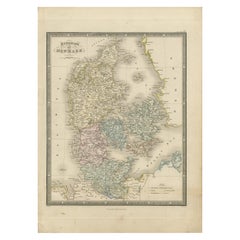
- Antique Map of the Kingdom of Denmark by Wyld '1845'Located in Langweer, NLAntique map titled 'Kingdom of Denmark'. Original antique map of the Kingdom of Denmark. This map originates from 'An Atlas of the World, Comprehending Separate Maps of its Various C...Category
Antique Mid-19th Century Maps
MaterialsPaper
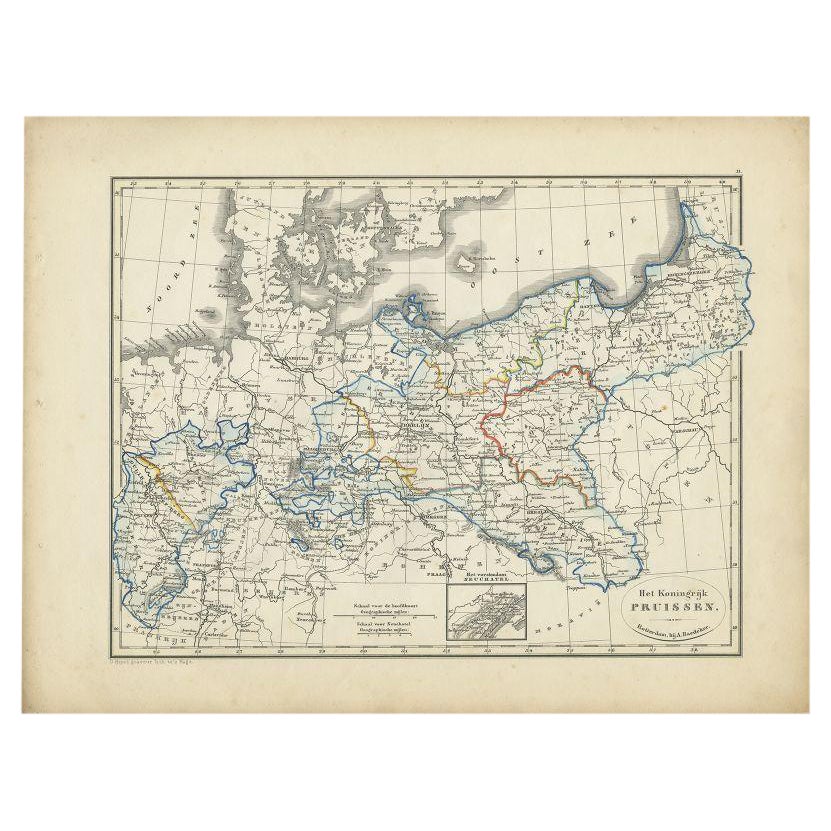
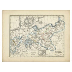
- Antique Map of the Kingdom of Prussia by Petri, 1852Located in Langweer, NLAntique map titled 'Het Koningrijk Pruissen'. Map of the Kingdom of Prussia. This map originates from 'School-Atlas van alle deelen der Aarde' by Otto Petri. Artists and Engraver...Category
Antique 19th Century Maps
MaterialsPaper


You May Also Like
- Map of the Kingdom of Sardinia and Part of the Kingdom of Genoa, RomeBy Giovanni Maria CassiniLocated in Hamilton, Ontario18th century map by Italian engraver Giovanni Maria Cassini (Italy 1745-1824). Map of Part of the Kingdom of Sardinia and Part of the Kingdom of Genoa: Rome. This is a hand colored a...Category
Antique 18th Century Italian Maps
MaterialsPaper
- Large Original Antique Folding Map of Manchester, England, Dated 1793Located in St Annes, LancashireSuperb map of Manchester and Salford Folding map. Printed on paper laid on to the original canvas Unframed. Published by C. Laurent, 1793. ...Category
Antique 1790s English Georgian Maps
MaterialsCanvas, Paper
- Large Original Vintage Map of The United Kingdom, circa 1920Located in St Annes, LancashireGreat map of The United Kingdom Original color. Published by Alexander Gross Unframed.Category
Vintage 1920s English Maps
MaterialsPaper
- Large Original Vintage Map of the United Kingdom, circa 1920Located in St Annes, LancashireGreat map of The United Kingdom Unframed Original color By John Bartholomew and Co. Edinburgh Geographical Institute Published, circa 1920 Free shipping.Category
Vintage 1920s British Maps
MaterialsPaper
- 1861 Topographical Map of the District of Columbia, by Boschke, Antique MapLocated in Colorado Springs, COPresented is an original map of Albert Boschke's extremely sought-after "Topographical Map of the District of Columbia Surveyed in the Years 1856 ...Category
Antique 1860s American Historical Memorabilia
MaterialsPaper
- Original Antique Map of Sweden, Engraved by Barlow, 1806Located in St Annes, LancashireGreat map of Sweden Copper-plate engraving by Barlow Published by Brightly & Kinnersly, Bungay, Suffolk. 1806 Unframed.Category
Antique Early 1800s English Maps
MaterialsPaper


Recently Viewed
View AllMore Ways To Browse
Unknown Swedish Artist
18th Century Small Swedish
Franz Collection
Antique Railroad Maps
Antique Florida Collectibles
Relief Map
West Coat Of Arms
Antique Map New York City
Antique Maps Of New York City
Antique New York City Maps
Map Of Massachusetts
Antique Tasmania
Antique Furniture Missouri
Maritime Chart
Southeast Asia Map
Biblical Maps
Church Yard
Migeon And Migeon