Items Similar to Antique Map of the Region of Zutphen in The Netherlands by Janssonius, 1647


Want more images or videos?
Request additional images or videos from the seller
1 of 5
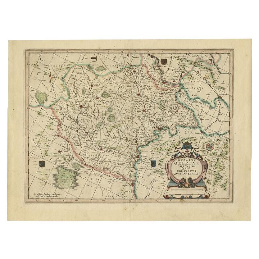
Antique Map of the Region of Zutphen in The Netherlands by Janssonius, 1647
About the Item
Antique map titled 'Ducatus Gelriae pars tertia Quae est Comitatus Zutphaniensis'. Antique map of the region of Zutphen, Gelderland, the Netherlands. This map originates from 'Atlas Novus sive Theatrum Orbis Terrarum', Amsterdam: Johannes Janssonius, 1647.
Artists and Engravers: Johannes Janssonius also known as Jan Jansson (1588-1664) was born in Arnhem, Netherlands. His father was a bookseller and publisher (Jan Janszoon the Elder). When he married the daughter of the cartographer Jodocus Hondius he also set up a business as book publisher in Amsterdam. His first map was published in 1616. Around 15 years later he set up a partnership with his brother in law Hondius add issued further editions of the Mercator/Hondius atlas. After his death his heirs still have published several maps. Many of his plates have been acquired by Pieter Schenk and Gerard Valk.
Condition: Good, given age. Paper separation at the lower middle fold margin, backed. Original middle fold as issued. Light brown offsetting from colours on oposing pages, as is common. General age-related toning and/or occasional minor defects from handling. Please study image carefully.
Date: 1647
Overall size: 59.1 x 48.5 cm.
Image size: 52.4 x 38.6 cm.
We sell original antique maps to collectors, historians, educators and interior decorators all over the world. Our collection includes a wide range of authentic antique maps from the 16th to the 20th centuries. Buying and collecting antique maps is a tradition that goes back hundreds of years. Antique maps have proved a richly rewarding investment over the past decade, thanks to a growing appreciation of their unique historical appeal. Today the decorative qualities of antique maps are widely recognized by interior designers who appreciate their beauty and design flexibility. Depending on the individual map, presentation, and context, a rare or antique map can be modern, traditional, abstract, figurative, serious or whimsical. We offer a wide range of authentic antique maps for any budget.
- Creator:Johannes Janssonius (Artist)
- Dimensions:Height: 19.1 in (48.5 cm)Width: 23.27 in (59.1 cm)Depth: 0 in (0.01 mm)
- Materials and Techniques:
- Period:
- Date of Manufacture:1647
- Condition:Condition: Good, given age. Paper separation at the lower middle fold margin, backed. Original middle fold as issued. Light brown offsetting from colours on oposing pages, as is common. General age-related toning and/or occasional minor defects.
- Seller Location:Langweer, NL
- Reference Number:
About the Seller
5.0
Platinum Seller
These expertly vetted sellers are 1stDibs' most experienced sellers and are rated highest by our customers.
Established in 2009
1stDibs seller since 2017
1,960 sales on 1stDibs
Typical response time: <1 hour
- ShippingRetrieving quote...Ships From: Langweer, Netherlands
- Return PolicyA return for this item may be initiated within 14 days of delivery.
More From This SellerView All
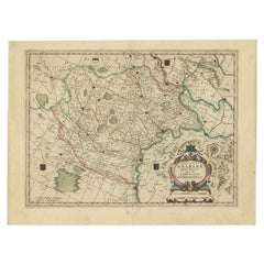
- Antique Map of the Region of Zutphen, Netherlands by Janssonius, c.1680By Johannes JanssoniusLocated in Langweer, NLAntique map titled 'Ducatus Gelriae pars tertia Quae est Comitatus Zutphaniensis.' Map of region around Zutphen in the historic Duchy Gelre in the Netherlands. Cities included in...Category
Antique 17th Century Maps
MaterialsPaper
- Antique Map of the Maine Region by Janssonius, 1657By Johannes JanssoniusLocated in Langweer, NLAntique map of France titled 'Diocese du Mans vulgo le Mains'. Decorative map of the region of Maine, France. This map originates from 'Atlas Novus, Sive Theatrum Orbis Orbis Terraru...Category
Antique 17th Century Maps
MaterialsPaper
- Antique Map of the Region of Zutphen in Overijssel, The Netherlands, 1683Located in Langweer, NLAntique map titled 'Ducatus Gelriae pars prima Quae est Neomagensis'. Antique map of the region of Zutphen, Gelderland, the Netherlands. This map originates from 'The English Atlas' ...Category
Antique 17th Century Maps
MaterialsPaper
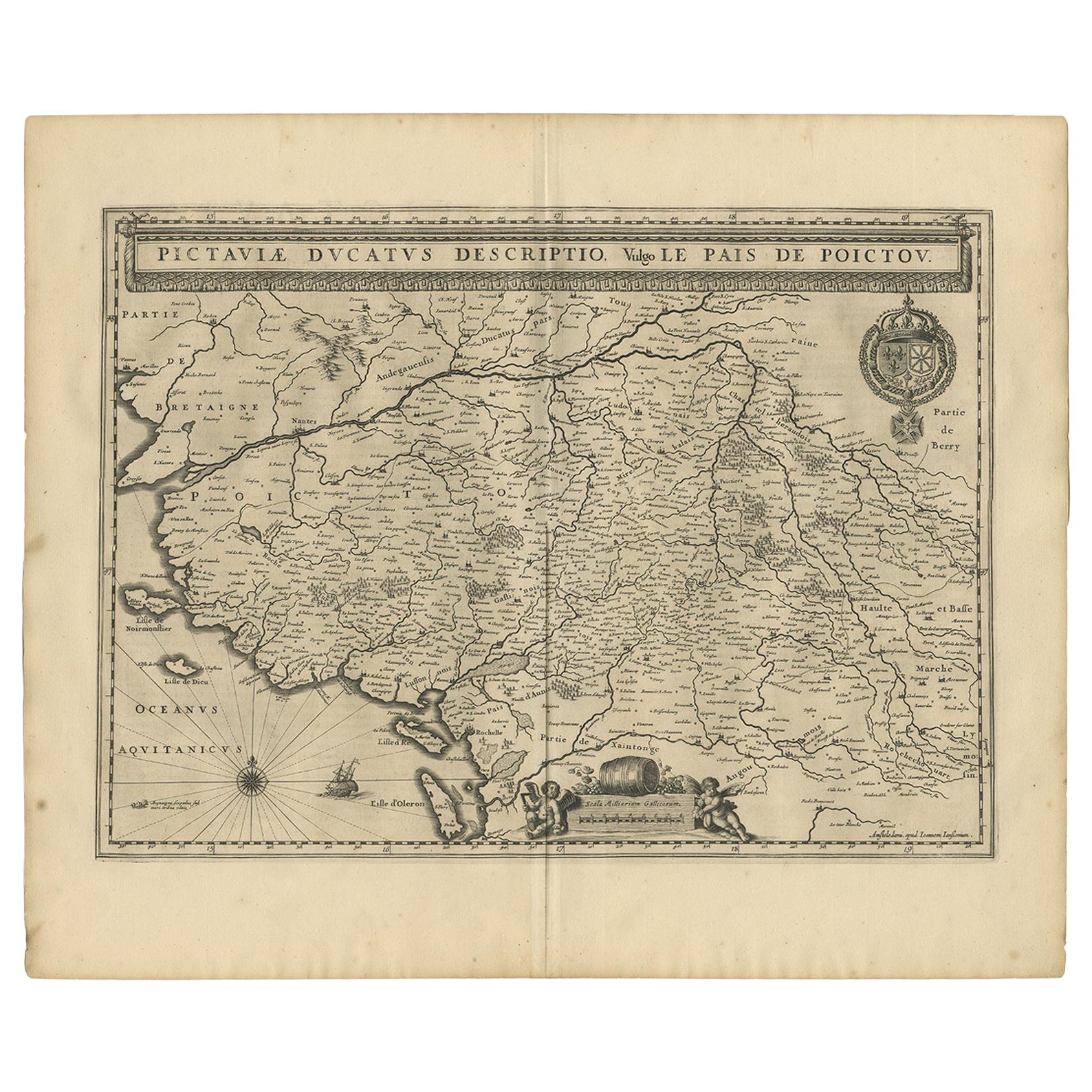
- Antique Map of the Region of Poitou by Janssonius, 1657By Johannes JanssoniusLocated in Langweer, NLAntique map 'Pictauiae Ducatus Descriptio vulgo le Pais de Poictov'. Decorative map of the region of Poitou with Rochelle, Nantes, etc., France. This map originates from 'Atlas Novus...Category
Antique Mid-17th Century Maps
MaterialsPaper
- Antique Map of the Region of Rethelois by Janssonius, 1657By Johannes JanssoniusLocated in Langweer, NLAntique map of France titled 'Dioecese de Rheims et le Païs de Rethel'. Detailed map, centered on the River Ayne and the River Velle and sowing Reims, Chalons, Sedan, Charleville, as...Category
Antique Mid-17th Century Maps
MaterialsPaper
- Antique Map of the Region of Picardy by Janssonius, 1657By Johannes JanssoniusLocated in Langweer, NLAntique map of France titled 'Picardia vera et inferior'. Detailed map of the Picardy region of France. This map originates from 'Atlas Novus, Sive Theatrum Orbis Orbis Terrarum: In ...Category
Antique Mid-17th Century Maps
MaterialsPaper


You May Also Like
- 17th Century Hand-Colored Map of a Region in West Germany by JanssoniusBy Johannes JanssoniusLocated in Alamo, CAThis attractive highly detailed 17th century original hand-colored map is entitled "Archiepiscopatus Maghdeburgensis et Anhaltinus Ducatus cum terris adjacentibus". It was published ...Category
Antique Mid-17th Century Dutch Maps
MaterialsPaper
- Prussia, Poland, N. Germany, Etc: A Hand-colored 17th Century Map by JanssoniusBy Johannes JanssoniusLocated in Alamo, CAThis is an attractive hand-colored copperplate engraved 17th century map of Prussia entitled "Prussia Accurate Descripta a Gasparo Henneberg Erlichensi", published in Amsterdam by Joannes Janssonius in 1664. This very detailed map from the golden age of Dutch cartography includes present-day Poland, Latvia, Lithuania, Estonia and portions of Germany. This highly detailed map is embellished by three ornate pink, red, mint green and gold...Category
Antique Mid-17th Century Dutch Maps
MaterialsPaper
- Original Antique Map of The Netherlands, Engraved by Barlow, Dated 1807Located in St Annes, LancashireGreat map of Netherlands Copper-plate engraving by Barlow Published by Brightly & Kinnersly, Bungay, Suffolk. Dated 1807 Unframed.Category
Antique Early 1800s English Maps
MaterialsPaper
- Original Antique Map of The Netherlands, Sherwood, Neely & Jones, Dated 1809Located in St Annes, LancashireGreat map of The Netherlands Copper-plate engraving by Cooper Published by Sherwood, Neely & Jones. Dated 1809 Unframed.Category
Antique Early 1800s English Maps
MaterialsPaper
- 17th Century Hand Colored Map of the Liege Region in Belgium by VisscherBy Nicolaes Visscher IILocated in Alamo, CAAn original 17th century map entitled "Leodiensis Episcopatus in omnes Subjacentes Provincias distincté divisusVisscher, Leodiensis Episcopatus" by Nicolaes Visscher II, published in Amsterdam in 1688. The map is centered on Liege, Belgium, includes the area between Antwerp, Turnhout, Roermond, Cologne, Trier and Dinant. This attractive map is presented in a cream-colored mat measuring 30" wide x 27.5" high. There is a central fold, as issued. There is minimal spotting in the upper margin and a tiny spot in the right lower margin, which are under the mat. The map is otherwise in excellent condition. The Visscher family were one of the great cartographic families of the 17th century. Begun by Claes Jansz Visscher...Category
Antique Late 17th Century Dutch Maps
MaterialsPaper
- The Normandy Region of France: A 17th C. Hand-colored Map by Sanson and JaillotBy Nicolas SansonLocated in Alamo, CAThis large hand-colored map entitled "Le Duché et Gouvernement de Normandie divisée en Haute et Basse Normandie en divers Pays; et par evêchez, avec le Gouvernement General du Havre ...Category
Antique 1690s French Maps
MaterialsPaper


Recently Viewed
View AllMore Ways To Browse
Chart Cabinet
Antique Surveying Level
J C Walker Map
Map Of Ancient Greece
Antique Mississippi Furniture
Filipino Map
Map Of Eastern Europe
Map Of Norway
Map Of Roman Empire
Map Of Virginia
Roman Empire Map
Antique Furniture Western Australia
Antique Maps Southeast Asia
Atlas Du Monde Antique
Caribbean Map
Greek Asia Minor
Henricus Hondius
Indian Ocean Antique Map