Items Similar to Antique Map of the Roadstead of Batavia by Van der Aa, 1725


Want more images or videos?
Request additional images or videos from the seller
1 of 5
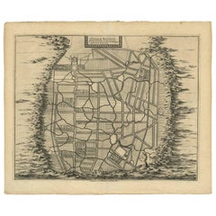
Antique Map of the Roadstead of Batavia by Van der Aa, 1725
About the Item
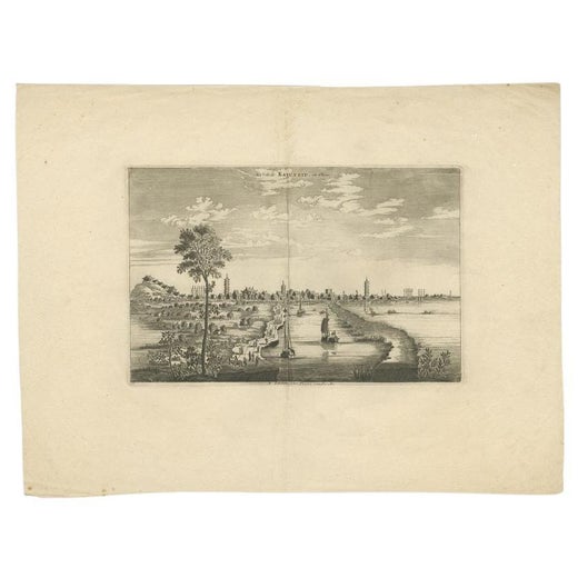
Antique map titled 'La rade de Batavia'. (The roadstead of Batavia.) This map shows the roadstead before the Indonesian city of Batavia, nowadays Jakarta. This plate originates from the very scarse: 'La galerie agreable du monde'. Tome premier des Indes Orientales.', published by P. van der Aa, Leyden, c. 1725. This famous work was published in 66 parts and is the biggest print / map book ever published. Van der Aa incorporated plates by other publishers such as Blaeu, Visscher, de Wit, meurs, Halma, Mortier, Allard in this work and often added broad decorative borders. Probably the costliest and complete universal geographic work ever produced. It is said that only 100 copies were printed. Ref: Koeman Aa9; Phillips 2780 note.
Artists and Engravers: Pieter van der Aa (Leiden 1659-1733) was a Dutch publisher best known for preparing maps and atlases. The Galerie Agreable contains plates and maps by the best Dutch engravers: Luiken, Goeree, Mulder, Stoopendaal, ao.
Condition: Good, General age related toning and occasional light staining from handling. Paper edge uncut and thus irregular. Original middle fold as issued. Please study image carefully.
Date: 1725
Overall size: 49 x 38 cm.
Image size: 15.5 x 16 cm.
We sell original antique maps to collectors, historians, educators and interior decorators all over the world. Our collection includes a wide range of authentic antique maps from the 16th to the 20th centuries. Buying and collecting antique maps is a tradition that goes back hundreds of years. Antique maps have proved a richly rewarding investment over the past decade, thanks to a growing appreciation of their unique historical appeal. Today the decorative qualities of antique maps are widely recognized by interior designers who appreciate their beauty and design flexibility. Depending on the individual map, presentation, and context, a rare or antique map can be modern, traditional, abstract, figurative, serious or whimsical. We offer a wide range of authentic antique maps for any budget.
- Creator:Pieter Van Der Aa (Artist)
- Dimensions:Height: 14.97 in (38 cm)Width: 19.3 in (49 cm)Depth: 0 in (0.01 mm)
- Materials and Techniques:
- Period:
- Date of Manufacture:1725
- Condition:
- Seller Location:Langweer, NL
- Reference Number:
Pieter Van Der Aa
Pieter van der Aa began his career at Leiden in 1683 as a Latin trade publisher, publishing classical texts about medicine and science. He was a Dutch publisher of maps and atlases active in the late 17th and early 18th centuries. During his long and impressive career, Van der Aa produced thousands of maps, including a vast 28 volume atlas containing no less than 3,000 maps.
About the Seller
5.0
Platinum Seller
These expertly vetted sellers are 1stDibs' most experienced sellers and are rated highest by our customers.
Established in 2009
1stDibs seller since 2017
1,960 sales on 1stDibs
Typical response time: <1 hour
- ShippingRetrieving quote...Ships From: Langweer, Netherlands
- Return PolicyA return for this item may be initiated within 14 days of delivery.
More From This SellerView All
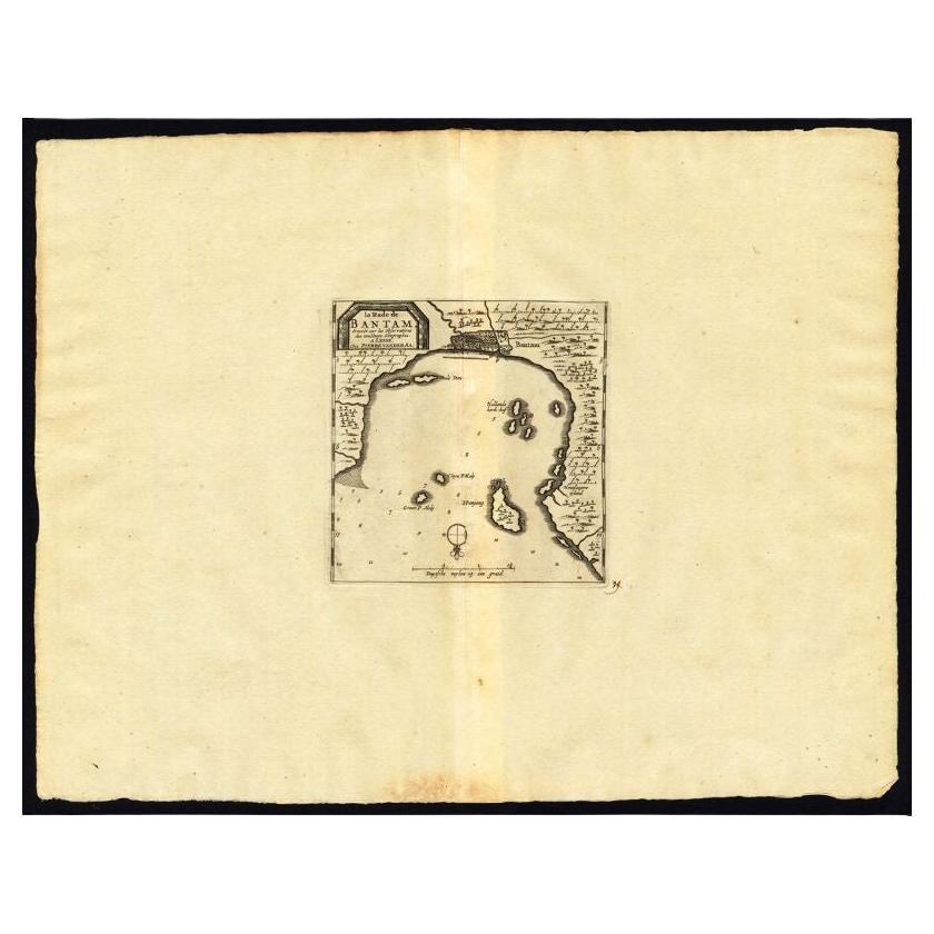
- Antique Map of the Roadstead of Bantam by Van der Aa, 1725By Pieter Van Der AaLocated in Langweer, NLAntique map titled 'La rade de Bantam'. (The roadstead of Bantam.) This map shows the Indonesian city of Banten / Bantam on Java, Indonesia and its roadstead. With compass rose and s...Category
Antique 18th Century Maps
MaterialsPaper
- Antique Map of the Maluku Islands by Van der Aa, 1725By Pieter Van Der AaLocated in Langweer, NLAntique map titled 'Les Iles Moluques (..).' (The Moluccan Islands, Maluku, Moluccas, Spice Islands, Indonesia.) Extremely rare in this edition. This plate originates from the very s...Category
Antique 18th Century Maps
MaterialsPaper
- Antique Map of the Mughal Empire by Van der Aa, C.1725By Pieter Van Der AaLocated in Langweer, NLAntique map titled 'Royaume de Grand Mogol (..).' This map shows the extend of the Mughal Empire, which includes northern India, from Golconda to Afghanistan and eastwards to Bengal....Category
Antique 18th Century Maps
MaterialsPaper
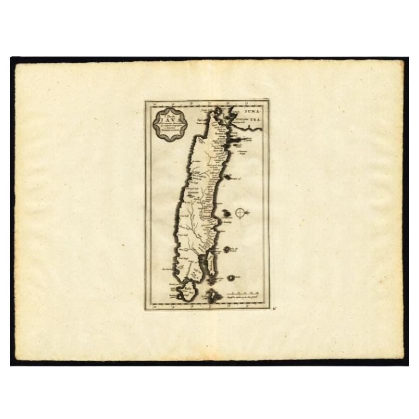
- Antique Map of the Island of Java by Van Der Aa, 1725By Pieter Van Der AaLocated in Langweer, NLAntique map titled 'Map: 'L'Ile de Java'. (The island of Java.) This map shows the Indonesian island of Java. With compass rose and scale. This plate originates from the very scarse:...Category
Antique 18th Century Maps
MaterialsPaper
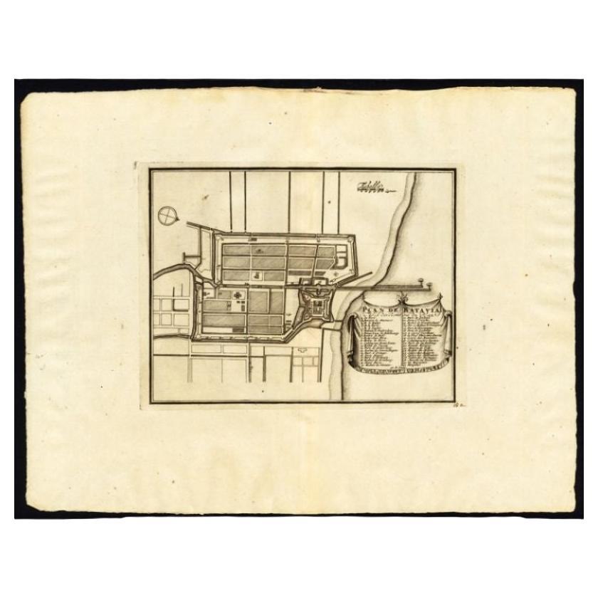
- Antique Plan of Batavia, Capital of the Dutch East Indies, by Van Der Aa, 1725By Pieter Van Der AaLocated in Langweer, NLAntique map titled 'Plan de Batavia'. (Plan of Batavia.) This plate shows a plan of the city of Batavia / Jakarta in Indonesia. With extensive legend, compass rose and scale. This pl...Category
Antique 18th Century Maps
MaterialsPaper
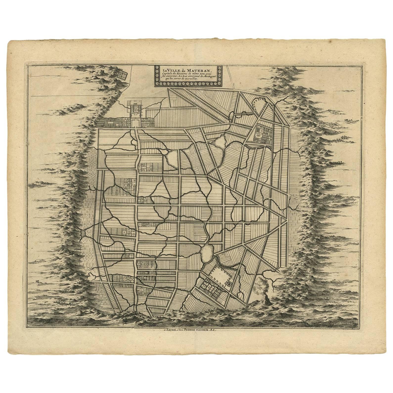
- Antique Map of the City of Materan 'Indonesia' by P. van der Aa, circa 1725By Pieter Van Der AaLocated in Langweer, NLAntique map titled 'La Ville de Materan, capitale de Roiaume de meme nom, avec ses environs. Le tout environne de Montagnes qui lui serve de murailles.' The city of Materan, capital ...Category
Antique Early 18th Century Maps
MaterialsPaper


You May Also Like
- London AA MapLocated in Alton, GBLondon AA map.Category
20th Century Maps
MaterialsPaper
- 1861 Topographical Map of the District of Columbia, by Boschke, Antique MapLocated in Colorado Springs, COPresented is an original map of Albert Boschke's extremely sought-after "Topographical Map of the District of Columbia Surveyed in the Years 1856 ...Category
Antique 1860s American Historical Memorabilia
MaterialsPaper
- The Last Flowering of the Middle Ages by Baron Van Der Elst, Stated 1st EdLocated in valatie, NYThe Last Flowering of the Middle Ages by Baron Joseph Van Der Elst. Published by Doubleday, Doran and Company Inc., 1944. Stated 1st Ed hardcover. An in-depth look into art of the Middle Ages. Contents: 1. The Times and the Men who Made Them: Men of Flanders; The Flemish Parade; The Good Black Earth; The Rise of the Towns; The Medieval Guilds; Of Love, the Dream; The Upward Glance; Pt. 2. The Flemish Masters: Jan van Eyck; Petrus Christus...Category
Vintage 1940s American Books
MaterialsPaper
- Original Antique Map of The World by Thomas Clerk, 1817Located in St Annes, LancashireGreat map of The Eastern and Western Hemispheres On 2 sheets Copper-plate engraving Drawn and engraved by Thomas Clerk, Edinburgh. Published by Mackenzie And Dent, 1817 ...Category
Antique 1810s English Maps
MaterialsPaper
- 1907 Map of Colorado, Antique Topographical Map, by Louis NellLocated in Colorado Springs, COThis highly detailed pocket map is a topographical map of the state of Colorado by Louis Nell from 1907. The map "has been complied from all availabl...Category
Antique Early 1900s American Maps
MaterialsPaper
- Original Antique Map of The Netherlands, Engraved by Barlow, Dated 1807Located in St Annes, LancashireGreat map of Netherlands Copper-plate engraving by Barlow Published by Brightly & Kinnersly, Bungay, Suffolk. Dated 1807 Unframed.Category
Antique Early 1800s English Maps
MaterialsPaper


Recently Viewed
View AllMore Ways To Browse
Batavia Furniture
Map Monde Antique
Atlas Du Monde Antique
Chart Cabinet
Antique Surveying Level
J C Walker Map
Map Of Ancient Greece
Antique Mississippi Furniture
Filipino Map
Map Of Eastern Europe
Map Of Norway
Map Of Roman Empire
Map Of Virginia
Roman Empire Map
Antique Furniture Western Australia
Antique Maps Southeast Asia
Atlas Du Monde Antique
Caribbean Map