Items Similar to Historical Large Map of Kyoto, Japan (1905) - Published by Kobayashi


Want more images or videos?
Request additional images or videos from the seller
1 of 6
Historical Large Map of Kyoto, Japan (1905) - Published by Kobayashi
About the Item
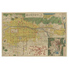
Old map of Kyoto, Japan. Published by Kobayashi, 1905.
This is an old map of Kyoto, Japan, published by Kobayashi in 1905. The map showcases a detailed layout of Kyoto during the early 20th century. Here is a description and some interesting aspects of the map:
1. **Layout and Design**:
- The map is highly detailed, with a grid-like layout that represents the city’s streets, buildings, and key landmarks.
- It includes color-coding to distinguish different areas or types of buildings, with shades of pink, yellow, and orange prominent.
2. **Geographical Features**:
- The map is bordered by mountainous regions, emphasizing Kyoto's location in a valley.
- Several rivers and waterways are depicted, including the Kamo River running through the city.
3. **Landmarks and Structures**:
- Major temples, shrines, and significant cultural landmarks are marked and often highlighted with specific illustrations or symbols.
- The Imperial Palace (Kyoto Gosho) is centrally located, indicating its importance.
4. **Surrounding Areas**:
- The outskirts of the map depict rural and forested areas, contrasting with the densely built-up city center.
5. **Text and Labels**:
- Japanese characters are used throughout the map to label districts, streets, and landmarks.
- The title of the map, which appears at the top, translates to "Map of Kyoto City".
### Interesting Aspects
1. **Historical Context**:
- This map provides a snapshot of Kyoto as it was in 1905, a period when Japan was modernizing rapidly after the Meiji Restoration.
- It reflects the blend of traditional and modern influences in the city at that time.
2. **Cartographic Style**:
- The map is hand-drawn with meticulous detail, characteristic of early 20th-century Japanese cartography.
- The artistic elements, such as the depiction of mountains and temples, highlight the aesthetic values of the period.
3. **Cultural Significance**:
- Kyoto is known for its historical and cultural heritage, and this map emphasizes many of the traditional sites that are still significant today.
- It serves as a historical document, showing the urban layout before modern developments altered the cityscape.
### About the Maker - Kobayashi
- **Kobayashi** was a common name in Japan, and without additional information, it is challenging to pinpoint the exact individual or publisher.
- The Kobayashi who created this map was likely a skilled cartographer or part of a publishing house specializing in maps and guides.
- During the early 20th century, many Japanese publishers produced maps for both local use and as guides for increasing numbers of travelers and scholars visiting historical cities like Kyoto.
This map is a valuable artifact for historians, geographers, and anyone interested in the evolution of Kyoto’s urban landscape and cultural heritage.
- Dimensions:Height: 21.26 in (54 cm)Width: 30.91 in (78.5 cm)Depth: 0.02 in (0.5 mm)
- Materials and Techniques:
- Period:
- Date of Manufacture:1905
- Condition:Wear consistent with age and use. Minor losses. Minor structural damages. Some minor defects on the folding lines, please study images carefully.
- Seller Location:Langweer, NL
- Reference Number:Seller: BG-117711stDibs: LU3054315760732
About the Seller
5.0
Platinum Seller
These expertly vetted sellers are 1stDibs' most experienced sellers and are rated highest by our customers.
Established in 2009
1stDibs seller since 2017
1,960 sales on 1stDibs
Typical response time: <1 hour
- ShippingRetrieving quote...Ships From: Langweer, Netherlands
- Return PolicyA return for this item may be initiated within 14 days of delivery.
Auctions on 1stDibs
Our timed auctions are an opportunity to bid on extraordinary design. We do not charge a Buyer's Premium and shipping is facilitated by 1stDibs and/or the seller. Plus, all auction purchases are covered by our comprehensive Buyer Protection. Learn More
More From This SellerView All
- Antique Folding Map of Kyoto, Japan, 1920Located in Langweer, NLAntique folding map of Kyoto, Japan. On the verso of this map photos of buildings, other structures and informative text can be found.Category
20th Century Maps
MaterialsPaper
- Attractive Hand-Tinted Antique Map of Japan, Published in 1752Located in Langweer, NLNice decorative hand tinted map of Japan with the title (in French): Carte de L'Empire du Japon Bellin, 1752 This antique map is engraved with very attractive title cartouche. ...Category
Antique 1750s Maps
MaterialsPaper
- Stunning Large Scale Antique Map of Martinique, Rare, Published 1758Located in Langweer, NLAntique map titled 'Carte Reduite de l'Isle de la Martinique Dressee au Depost des Cartes Plans et Journaux de la Marine.' Superb, large scale chart of th...Category
Antique 18th Century Maps
MaterialsPaper
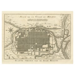
- Antique Plan of Meaco, Kyoto, JapanLocated in Langweer, NLAntique map titled 'Plan de la Ville de Meaco - Platte-Grond van de Stad Miaco'. Detailed and unusual antique copper engraved plan of Kyoto, ancient named Meaco, when it was the capi...Category
Antique Mid-18th Century Maps
MaterialsPaper
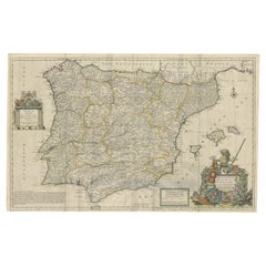
- Beautiful Large Scale Map of Spain and Portugal Published by Herman Moll in 1711Located in Langweer, NLTitle: A New and Exact Map of Spain & Portugal Author: Herman Moll Date: 1711 Medium: ?Hand-colored copperplate engraving Condition: Very good - light age toning, light wear and discoloration along issued quatrefolds, surface dirt, minor creasing throughout,. Large engraved map on two conjoined sheets, contemporary outline colouring with some later enhancement inches. Herman Moll (c. 1654-1732) was one of the most important London mapmakers in the first half of the eighteenth century. Moll was probably born in Bremen, Germany, around 1654. He moved to London to escape the Scanian Wars. His earliest work was as an engraver for Moses Pitt on the production of the English Atlas, a failed work which landed Pitt in debtor's prison. Moll also engraved for Sir Jonas Moore, Grenville Collins, John Adair, and the Seller & Price firm. He published his first original maps in the early 1680s and had set up his own shop by the 1690s. Moll's work quickly helped him become a member of a group which congregated at Jonathan's Coffee House at Number 20 Exchange Alley, Cornhill, where speculators met to trade stock. Moll's circle included the scientist Robert Hooke...Category
Antique 1710s Maps
MaterialsPaper
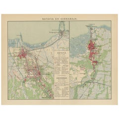
- Antique Map of Batavia and Surabaya by Winkler Prins, 1905Located in Langweer, NLAntique map titled 'Batavia en Soerabaja'. Detailed plan of Batavia (Jakarta) and Soerabaja (Surabaya), Indonesia. The plans include important places like Tandjoeng Priok, Oedjong, W...Category
20th Century Maps
MaterialsPaper
You May Also Like
- Large Antique 1859 Map of North AmericaLocated in Sag Harbor, NYThis Map was made by Augustus Mitchell in 1859 It is in amazing condition for being 163 years old. This price is for the rolled up easy to ship version of this piece. I will be Frami...Category
Antique Mid-19th Century American Maps
MaterialsCanvas, Paper

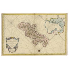
- Antique Map of Italy by Andriveau-Goujon, 1843By Andriveau-GoujonLocated in New York, NYAntique Map of Italy by Andriveau-Goujon, 1843. Map of Italy in two parts by Andriveau-Goujon for the Library of Prince Carini at Palazzo Carini i...Category
Antique 1840s French Maps
MaterialsLinen, Paper
- Antique Map of Principality of MonacoBy Antonio Vallardi EditoreLocated in Alessandria, PiemonteST/619 - "Old Geographical Atlas of Italy - Topographic map of ex-Principality of Monaco" - ediz Vallardi - Milano - A somewhat special edition ---Category
Antique Late 19th Century Italian Other Prints
MaterialsPaper
- Map of the Republic of GenoaLocated in New York, NYFramed antique hand-coloured map of the Republic of Genoa including the duchies of Mantua, Modena, and Parma. Europe, late 18th century. Dimension: 25...Category
Antique Late 18th Century European Maps
- Old Nautical Map of CorsicaLocated in Alessandria, PiemonteST/556/1 - Old map of Corsica isle, surveyed by Captain Hell, of the French Royal Navy in 1824, engraved and published on 1874, with additions and corre...Category
Antique Early 19th Century English Other Prints
MaterialsPaper
- Old Horizontal Map of EnglandBy TassoLocated in Alessandria, PiemonteST/520 - Old rare Italian map of England, dated 1826-1827 - by Girolamo Tasso, editor in Venise, for the atlas of M.r Le-Sage.Category
Antique Early 19th Century Italian Other Prints
MaterialsPaper


Recently Viewed
View AllMore Ways To Browse
Japanese Antique Collectables
Japan Antiques Collectables
Collectible Artifacts
Antique Map Border
Japan Maps
Map Of Japan
Antique Japanese Map
Antique Japanese Maps
Temple Shrine
Artifact Japan
Meiji Shrine
Buy Antique Paper
Map Of Itsly
World Atlas
Antique Maps 18th Century
Antique Old Maps
Used World Atlas
Antique German Collectibles