Items Similar to Mediterranean Tapestry: A 19th Century Map of the Mediterranean Shores, 1882

Want more images or videos?
Request additional images or videos from the seller
1 of 7
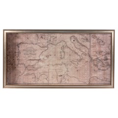
Mediterranean Tapestry: A 19th Century Map of the Mediterranean Shores, 1882
About the Item
This map, titled "The Shores of the Mediterranean," is part of the 1882 atlas by Blackie & Son, and it portrays the coastal regions that surround the Mediterranean Sea. It is a detailed representation of the diverse and historically rich countries that share the Mediterranean coastline, spanning from the Strait of Gibraltar in the west to the Levantine Sea in the east, and from the southern shores of Europe down to the northern coastlines of Africa.
The map is a vivid document of the time, with each country along the Mediterranean basin meticulously outlined. The northern coast includes the southern parts of Europe, featuring Spain, France, Italy, and the Balkan states, extending to the Anatolian peninsula. The southern coast covers the Maghreb countries of North Africa and the Nile delta, proceeding to the Middle East.
Topographical features such as mountain ranges, valleys, and plateaus are carefully delineated, providing a sense of the varied landscapes that contribute to the region's climatic and cultural diversity. The map's coloration is nuanced, with political boundaries highlighted in gentle shades that distinguish each nation while not overpowering the map's geographical details.
Cities and ports are pinpointed, indicative of the Mediterranean's role as a nexus of trade, civilization, and cultural exchange throughout history. Routes and passages are marked, suggesting the lines of maritime navigation that have been central to the region's economic lifeblood.
This map serves not only as a geographical reference but also as a historical snapshot of the Mediterranean region during a period of significant change. It reflects the geopolitical realities prior to the upheavals of the 20th century, capturing an era when the Mediterranean was a border between empires and a bridge linking continents.
- Dimensions:Height: 11.03 in (28 cm)Width: 14.97 in (38 cm)Depth: 0 in (0.02 mm)
- Materials and Techniques:
- Period:
- Date of Manufacture:1882
- Condition:Good condition. Study the image carefully.
- Seller Location:Langweer, NL
- Reference Number:
About the Seller
5.0
Platinum Seller
These expertly vetted sellers are 1stDibs' most experienced sellers and are rated highest by our customers.
Established in 2009
1stDibs seller since 2017
1,965 sales on 1stDibs
Typical response time: <1 hour
- ShippingRetrieving quote...Ships From: Langweer, Netherlands
- Return PolicyA return for this item may be initiated within 14 days of delivery.
More From This SellerView All
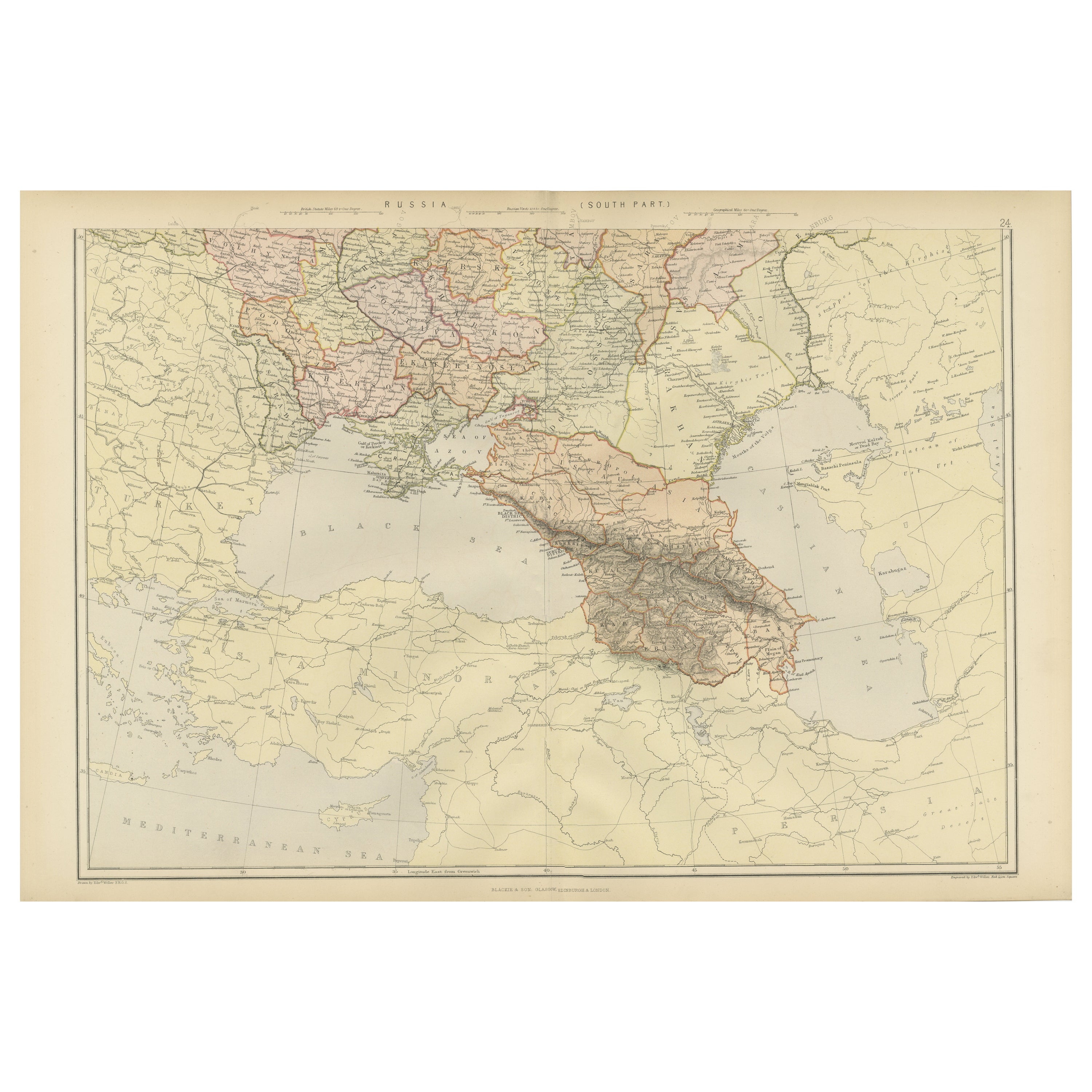
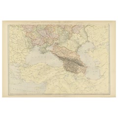
- Imperial Frontiers: A 19th Century Map of Southern Russia and the Caucasus, 1882Located in Langweer, NLThis map, sourced from the comprehensive 1882 atlas by Blackie & Son, delineates the southern part of Russia and the Caucasus region, reflecting the geopolitical contours and topogra...Category
Antique 1880s Maps
MaterialsPaper
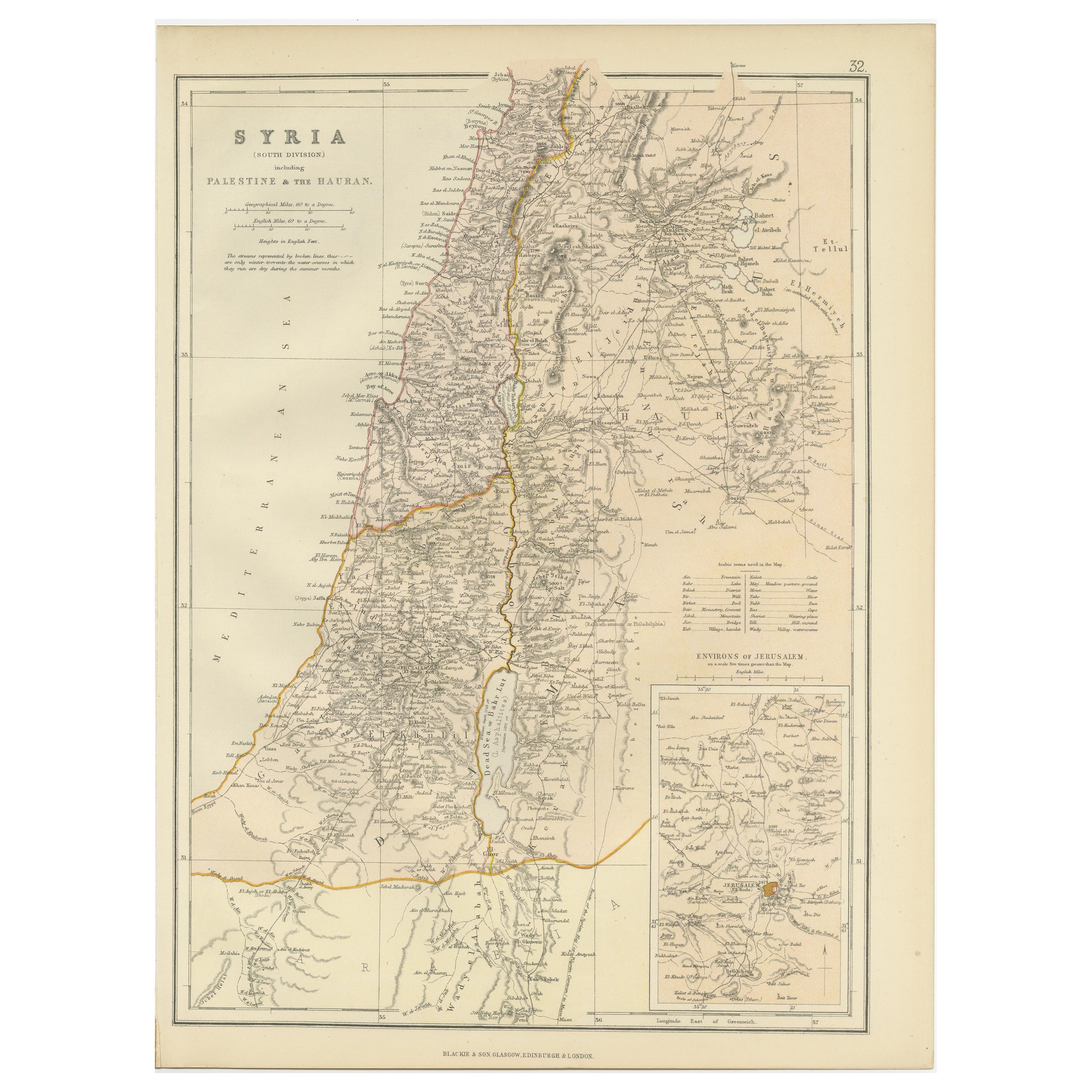
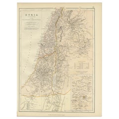
- An Insightful 19th Century Map of Syria and the Surrounding Regions, 1882Located in Langweer, NLThis map, titled "SYRIA (SOUTH DIVISION) including PALESTINE & THE HAUARAN," is a historical cartographic work from the late 19th century, specifically from the 1882 atlas by Blackie...Category
Antique 1880s Maps
MaterialsPaper
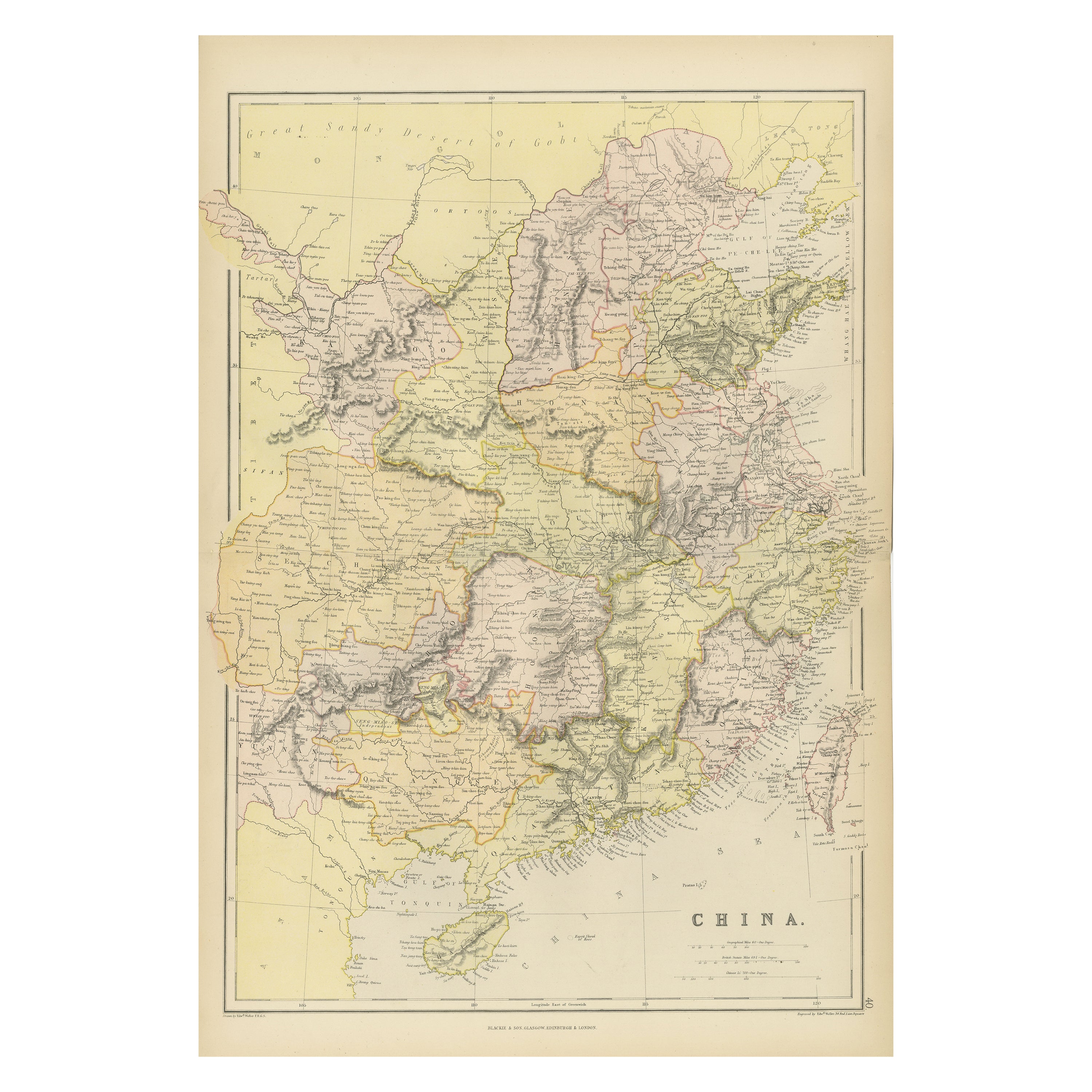
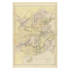
- Antique 19th Century Map of China by Blackie & Son, 1882Located in Langweer, NLThis map is an 1882 Blackie & Son map of China. The title "CHINA." is prominently displayed at the bottom. The map is colored to differentiate various regions, possibly indicating di...Category
Antique 1880s Maps
MaterialsPaper
- Antique Map of the European Continent, 1882Located in Langweer, NLAntique map titled 'Europe'. Old map of the European continent. This map originates from 'The Royal Atlas of Modern Geography, Exhibiting, in a Series of Entirely Original and Authen...Category
Antique 19th Century Maps
MaterialsPaper
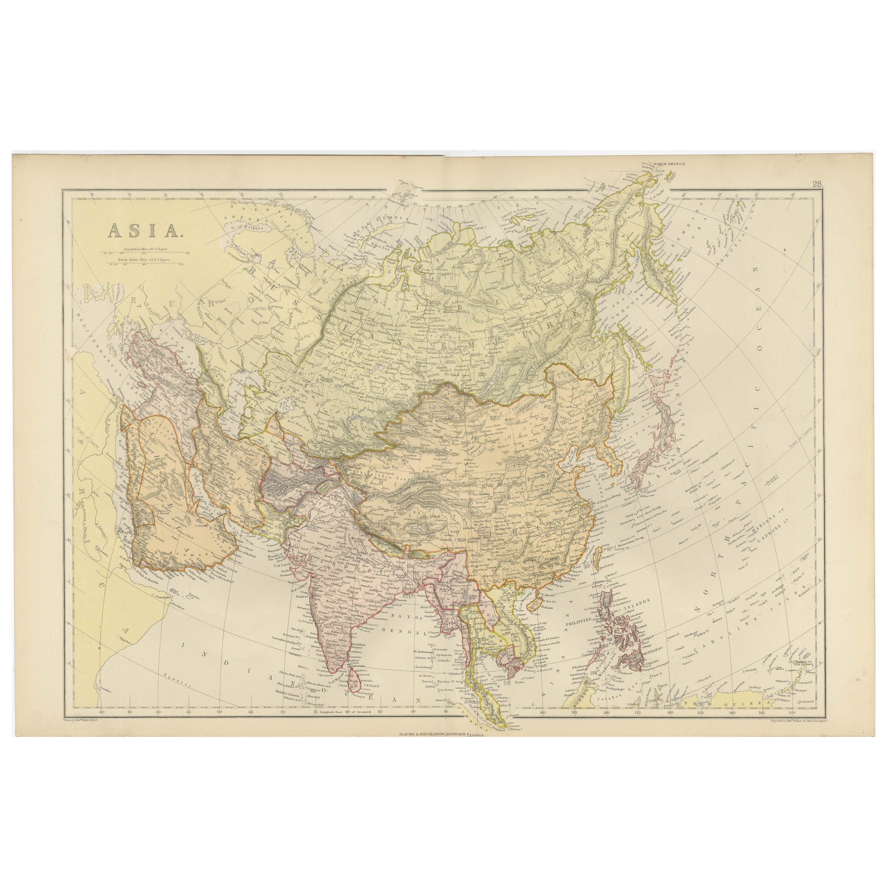
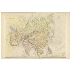
- Historical Map Depicting the Continent of Asia, 1882Located in Langweer, NLThis 1882 map presents a meticulously detailed representation of the continent of Asia, a testament to the cartographic skills of the era. Published as a part of 'Comprehensive Atlas...Category
Antique 1880s Maps
MaterialsPaper
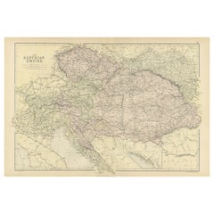
- Original Antique Map of The Austrian Empire, 1882Located in Langweer, NLStep into the past with an original Antique Map of The Austrian Empire from the esteemed 'Comprehensive Atlas and Geography of the World,' meticulously crafted in 1882. This intricat...Category
Antique 1880s Maps
MaterialsPaper

You May Also Like
- Large Framed Map of the MediterraneanLocated in New York, NYLarge map/chart chart of The Mediterranean and the Grecian Archipelago showing Italy, Sardinia, Corsica, part of France, etc. in a black frame.Category
20th Century French Mid-Century Modern Maps
- Framed Mid-19th Century Wall Map of Long Island, the HamptonsLocated in Sag Harbor, NYA Framed museum quality find. This large wall map dates to the mid-1800s. Detailed inset maps of, Sag Harbor, East Hampton, Amagansett, Shelter Island and most villages in Long Islan...Category
Antique Mid-19th Century American Maps
MaterialsLinen, Paper
- Brooch in the Shape of a Cross 19th Century 19th CenturyBy Europa AntiquesLocated in Madrid, ESBrooch in the shape of a cross xix century It is made of wood and golden metal. Measures: 8 x 5 cm Good condition.Category
Antique 19th Century Italian Gothic Religious Items
MaterialsBronze
- 19th Century Lithograph Map of Lower Manhattan, New YorkLocated in Haddonfield, NJ1859 hand colored map of Lower Manhattan or New Amsterdam by George H. Moore.Category
Antique 19th Century English Folk Art Maps
MaterialsPaper
- Louisiana: A Framed 19th Century Map by O. W. GrayBy Gray and CoLocated in Alamo, CAThis framed 19th century map of the Louisiana territory was published in "Gray's Atlas of the United States with General Maps of the World, accompanied by Descriptions Geographical, Historical, Scientific and Statistica" published in 1873 in Philadelphia by O.W. Gray and Son and Stedman, Brown and Lyon. It is a highly detailed map of Louisiana...Category
Antique Mid-19th Century American Other Maps
MaterialsPaper
- Early 19th Century Hand Colored Map of the United States and Caribbean IslandsLocated in Hamilton, OntarioHand coloured early 19th century map by Giraldon of France titled "Etats Unis et Grandes Antilles" (United States and Greater Antilles).Category
Antique Early 19th Century French Maps
MaterialsPaper


Recently Viewed
View AllMore Ways To Browse
Antique Italian Tapestry
Mountain Tapestry
Antique Balkan
Period Basins
1880 Southern Furniture
North Africa Map
Antique Spanish Tapestry
Used Furniture North Shore
Italian 19th Century Tapestry
Maps Balkans
Gibraltar Antique Map
West African Tapestry
Antique Vineyard Map
Atlas Map Relief
Bohemia Map
Map Egypt Nile
Map Of Alaska
Used Britannia Rose Furniture