Items Similar to Original Antique Map of Belgium by Tallis, Circa 1850


Want more images or videos?
Request additional images or videos from the seller
1 of 5
Original Antique Map of Belgium by Tallis, Circa 1850
About the Item
Great map of Belgium
Steel engraving
Many lovely vignettes
Published by London Printing & Publishing Co. ( Formerly Tallis ), C.1850
Original colour
Free shipping.
- Dimensions:Height: 13.75 in (34.93 cm)Width: 10.75 in (27.31 cm)Depth: 0.07 in (1.78 mm)
- Materials and Techniques:Paper,Other
- Place of Origin:
- Period:
- Date of Manufacture:1850
- Condition:Wear consistent with age and use.
- Seller Location:St Annes, GB
- Reference Number:1stDibs: LU1836330327062
About the Seller
4.9
Platinum Seller
These expertly vetted sellers are 1stDibs' most experienced sellers and are rated highest by our customers.
1stDibs seller since 2016
2,638 sales on 1stDibs
Typical response time: <1 hour
Associations
International Confederation of Art and Antique Dealers' Associations
- ShippingRetrieving quote...Ships From: St Annes, United Kingdom
- Return PolicyA return for this item may be initiated within 3 days of delivery.
Auctions on 1stDibs
Our timed auctions are an opportunity to bid on extraordinary design. We do not charge a Buyer's Premium and shipping is facilitated by 1stDibs and/or the seller. Plus, all auction purchases are covered by our comprehensive Buyer Protection. Learn More
More From This SellerView All
- Original Antique Map / City Plan of Brussels by Tallis, circa 1850Located in St Annes, LancashireGreat map of Brussels. Steel engraving. Published by London Printing & Publishing Co. (Formerly Tallis), C.1850 Free shipping.Category
Antique 1850s English Maps
MaterialsPaper
- Original Antique Map of South America, circa 1830Located in St Annes, LancashireGreat map of South America Copper plate engraving Published by Butterworth, Livesey & Co., circa 1830 Unframed.Category
Antique Early 1800s English Other Maps
MaterialsPaper
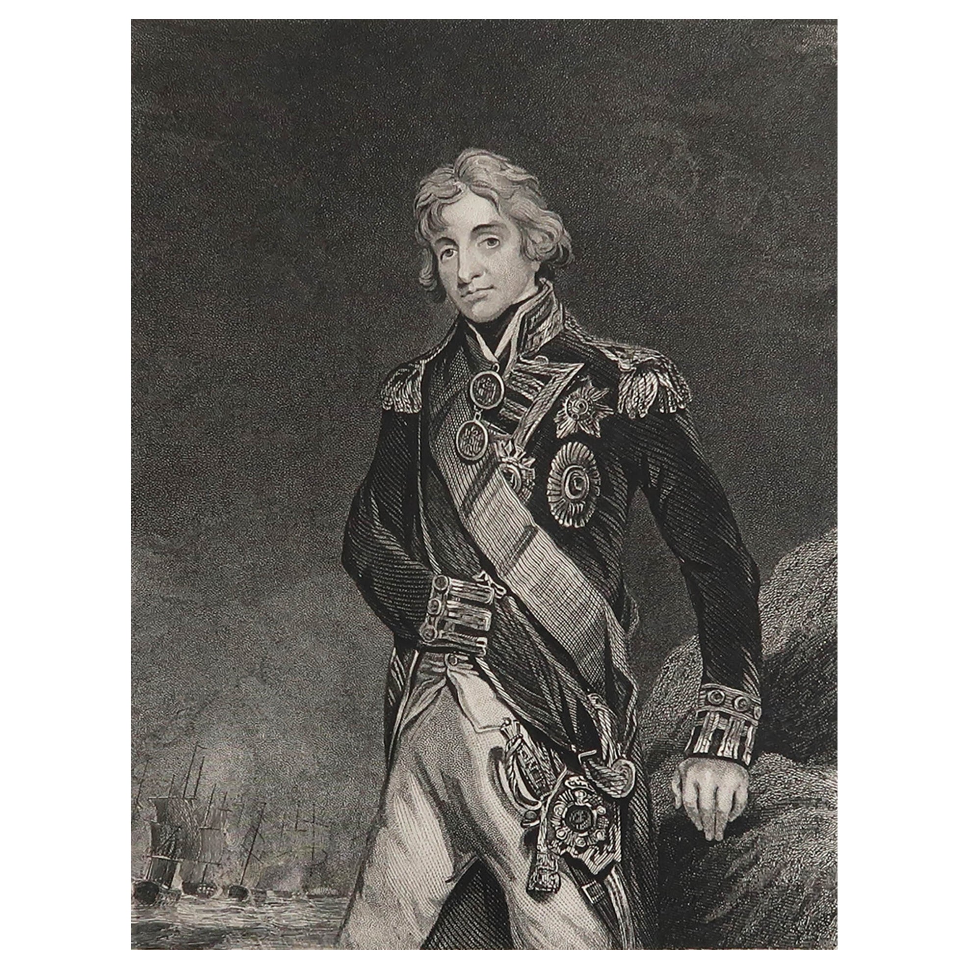
- Original Antique Print, Portrait of Lord Nelson, circa 1850Located in St Annes, LancashireGreat image of Lord Nelson Fine steel engraving by H.Robinson After J.Hoppner Published circa 1850 Unframed.Category
Antique 1850s English Prints
MaterialsPaper
- Original Antique Map of Russia By Arrowsmith. 1820Located in St Annes, LancashireGreat map of Russia Drawn under the direction of Arrowsmith Copper-plate engraving Published by Longman, Hurst, Rees, Orme and Brown, 1820 Unframed.Category
Antique 1820s English Maps
MaterialsPaper
- Original Antique Map of Asia. C.1780Located in St Annes, LancashireGreat map of Asia Copper-plate engraving Published C.1780 Two small worm holes to right side of map Unframed.Category
Antique Early 1800s English Georgian Maps
MaterialsPaper

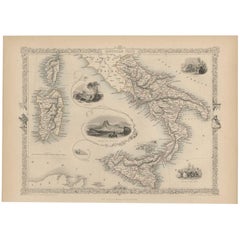
- Original Antique Map of Italy. C.1780Located in St Annes, LancashireGreat map of Italy Copper-plate engraving Published C.1780 Unframed.Category
Antique Early 1800s English Georgian Maps
MaterialsPaper


You May Also Like
- Antique Map of Belgium by J. Tallis, circa 1851Located in Langweer, NLA highly decorative and detailed mid-19th century map of Belgium which was drawn and engraved by J. Rapkin (vignettes by J. Marchant and J. B. Allen) an...Category
Antique Mid-19th Century Maps
MaterialsPaper
- Antique Map of British America by Tallis 'c.1850'Located in Langweer, NLAntique map titled 'British America'. Decorative map of British America, with vignettes showing Whale Fishing, Montreal, Fury and Hecla ships asail. Thi...Category
Antique Mid-19th Century Maps
MaterialsPaper
- Antique Map of Switzerland by J. Tallis, circa 1851Located in Langweer, NLA decorative and detailed mid-19th century map of Switzerland which was drawn and engraved by J. Rapkin (vignettes by A. H. Wray & J. B. Allen) and published in John Tallis's Illustr...Category
Antique Mid-19th Century Maps
MaterialsPaper
- Antique Map of Southern Italy by J. Tallis, circa 1851Located in Langweer, NLDecorative and detailed mid-19th century map of Southern Italy which was drawn and engraved by John Rapkin (vignettes by A. H. Wray and J. Rogers...Category
Antique Mid-19th Century Maps
MaterialsPaper
- Antique Map of Asia Minor by J. Tallis, circa 1851Located in Langweer, NLA highly decorative mid-19th century map of 'Asia Minor' (modern day Turkey) which was drawn and engraved by J. Rapkin and published in John Tallis's Illust...Category
Antique Mid-19th Century Maps
MaterialsPaper
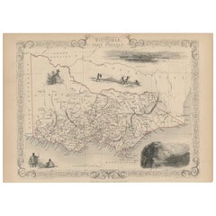
- Antique Map of Victoria ‘Australia’ by J. Tallis, circa 1855Located in Langweer, NLA highly decorative and finely engraved mid-19th century map of Victoria, Australia which appeared in John Tallis & co.'s The Illustrated Atlas (London...Category
Antique Mid-19th Century Maps
MaterialsPaper


Recently Viewed
View AllMore Ways To Browse
England 1850
London 1850
Maps Tallis
Antique Texas Collectables
Antique Furniture Alexandria
Victorian Fence
Alexandria Antique Furniture
Battle Maps
Antique Malaysia
Russian Antique Plates
Antique Railroad Collectables
Antique Railroad Collectibles
Floor Vase Wood
Antique Railroad Collectibles Collectibles
Mariner Furniture
Map Print Set
Antique World Globe Map
Antique Blackwood