Items Similar to Schley, Xinjiang Uygur Zizhiqu, Tien Shan, Sinkiang, Map of China

Want more images or videos?
Request additional images or videos from the seller
1 of 7
Schley, Xinjiang Uygur Zizhiqu, Tien Shan, Sinkiang, Map of China
About the Item
J.V. Schley
Carte de la petite Bukharie et pays voisins ; Kaart van Klyn-Bukharia, en de nabuurige landen
Xinjiang Uygur Zizhiqu (China), Tien Shan, Sinkiang. Relief shown pictorially.
Netherlands, 1749.
Measures: 27 x 36 cm
The Tian Shan, also known as the Tengri Tagh or Tengir-Too, meaning the Mountains of Heaven or the Heavenly Mountain, is a large system of mountain ranges located in Central Asia. The highest peak in the Tian Shan is Jengish Chokusu, at 7,439 metres high. Its lowest point is the Turpan Depression, which is 154 m below sea level.
Xinjiang, an autonomous territory in northwest China, is a vast region of deserts and mountains. It's home to many ethnic minority groups, including the Turkic Uyghur people. The ancient Silk Road trade route linking China and the Middle East passed through Xinjiang, a legacy that can be seen in the traditional open-air bazaars of its oasis cities, Hotan and Kashgar.
Excellent condition on fine strong laid paper. Folds as issued.
- Creator:Jacques-Nicolas Bellin (Artist)
- Dimensions:Height: 10.63 in (27 cm)Width: 14.18 in (36 cm)Depth: 0.04 in (1 mm)
- Materials and Techniques:Paper,Etched
- Place of Origin:
- Period:1740-1749
- Date of Manufacture:1749
- Condition:Wear consistent with age and use.
- Seller Location:Norwich, GB
- Reference Number:1stDibs: LU7031230847132

Jacques-Nicolas Bellin
Jacques Nicolas Bellin (1703 –1772) was a French hydrographer (official cartographer) and a geographer. While still a teenager he became the chief cartographer to the French Navy and later to the king of France. Bellin created a large number of maps for Antoine François Prévost's (L'Abbe Prevost) 'Histoire Generale des Voyages', which was a 25 volume publication focused on 17th and 18th century exploration.It was published in French, Dutch and German. He also contributed maps and articles to the 35-volume Encyclopédie edited by Denis Diderot and Jean le Rond d'Alembert. He was part of the group called Philosophes, which included many of the great intellectuals of the Age of Enlightenment, including Voltaire, Rousseau and Montesquieu. Bellin died at Versailles in 1772.
About the Seller
No Reviews Yet
Vetted Seller
These experienced sellers undergo a comprehensive evaluation by our team of in-house experts.
Established in 1992
1stDibs seller since 2022
9 sales on 1stDibs
- ShippingRetrieving quote...Ships From: Norwich, United Kingdom
- Return PolicyA return for this item may be initiated within 14 days of delivery.
More From This SellerView All
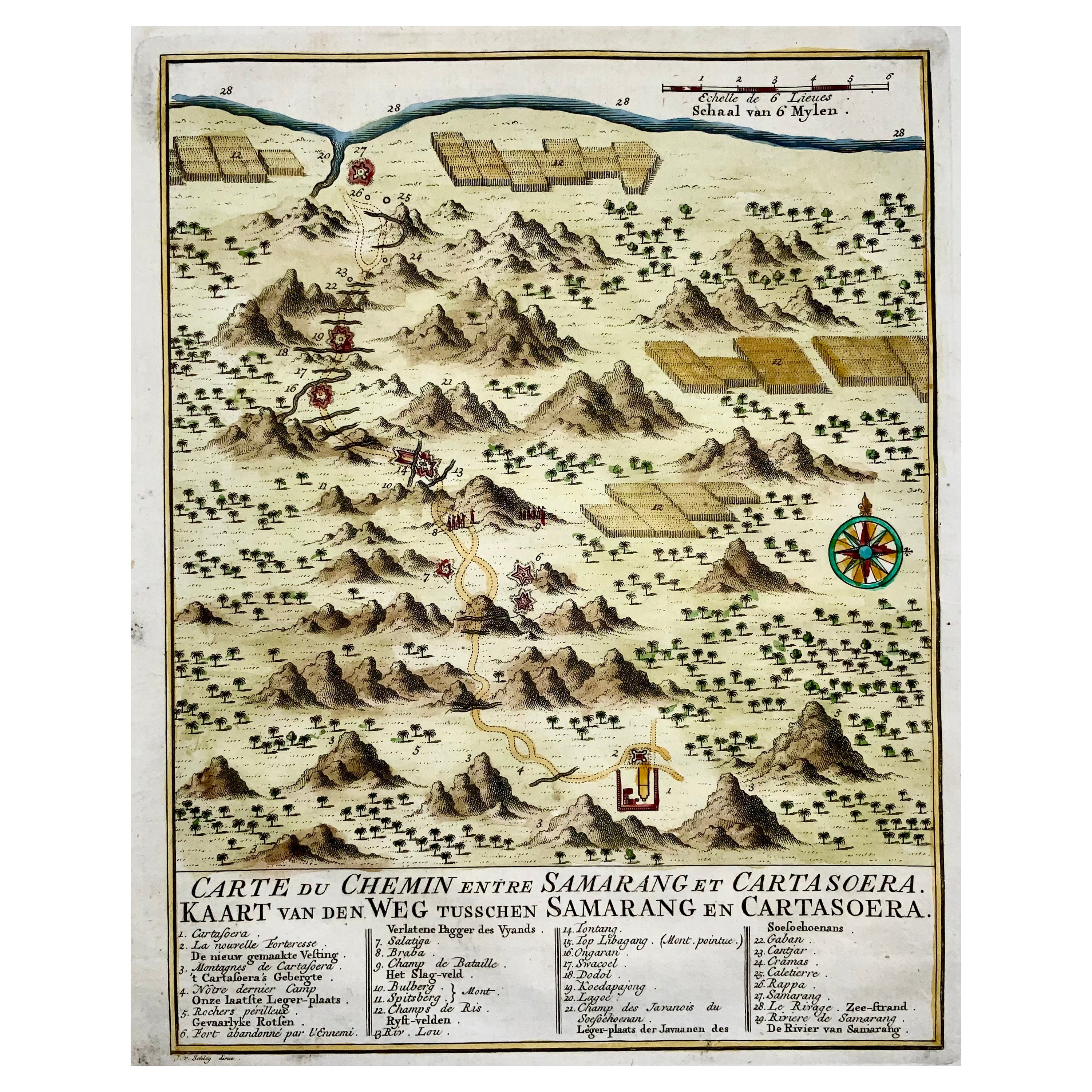
- Map of Indonesia, Semarang, Kartasoera, Soerabaya by SchleyBy Jakob van der SchleyLocated in Norwich, GB'Carte du Chemin entre Samarang et Cartasoera, kaart van den weg tusschen Samarang en Cartasoera' Map of the Road between Semarang and Kartasura by Van Schley. Published 1763. ...Category
Antique 1760s Indonesian Georgian Prints
MaterialsPaper
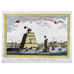
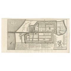
- Prevost; Schley, Fortress on the Beijing River, ChinaBy PrevostLocated in Norwich, GBForteresse de Tyen Tsing Wey, tiree de Nieuhof Published ca 1755. Fine hand colour. Rare original copper plate engraved antique print the Fortress (long ago demolished) guarding the cross roads of the meeting of the major rivers in Beijing (Peking) by Jakob van Schley - after Nieuhoff - in 1755 and published in Antoine François Prevost’s 15 volumes of Histoire Generale des Voyages written by Prevost & other authors between 1746-1789. Several major rivers, including the Yongding, Chaobai, Juma and Wenyu flow through Beijing Municipality. They originate in the highlands of Hebei and Shanxi, cut through the mountains west...Category
Antique 1750s Chinese Georgian Prints
MaterialsPaper
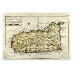
- Jacques Nicolas Bellin, St Lucia, West Indies, Hand Colored MapBy Jacques-Nicolas BellinLocated in Norwich, GBCarte De L’Isle De Sainte Lucie Detailed copper engraved map of Saint Lucia by Jacques Nicolas Bellin. This map was completed by Krevely 1775 for for the rare Dutch edition of ...Category
Antique 1770s Dutch Georgian Prints
MaterialsPaper
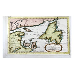
- Bellin, Canada, Gulf of Saint Lawrence, Hand Coloured EngravingBy Jacques-Nicolas BellinLocated in Norwich, GBJ.V. Schley after Bellin ‘Carte du Golphe de St. Laurent et Pays Voisins’ Size: 14.2 x 8.6 inches 36.1 x 21.8 cm First state of this nice copper engraved map of St. Lawrence Bay with Anticosti Island, Prince Edward Island, Cape Breton...Category
Antique 1780s French Prints
MaterialsPaper
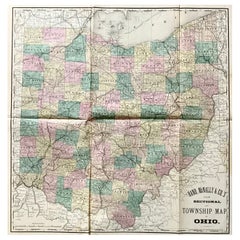
- Hardesty, Sectional & Township Map of Ohio, Very LargeLocated in Norwich, GBRand, McNally & Co.'s New Sectional And Township Map of Ohio 24.8 x 24.3 inches folding into 6 sections. Colour printed in part. Chicago, 1880. Scale: 1:633,600 Fine early large scale map...Category
Antique 1880s American Prints
MaterialsPaper
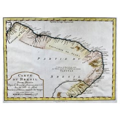
- Krevelt, Map, Coast of Brazil, South America, Amazon, Hand ColouredLocated in Norwich, GBCarte Du Bresil Prem. Partie Depuis la Riviere des Amazones jusqu' à la Baie de Tous les Saints Pour servir à l'Histoire des Etablissemens Europeens. A. v. Krevelt, sculpsit, ...Category
Antique Late 18th Century French Prints
MaterialsPaper

You May Also Like
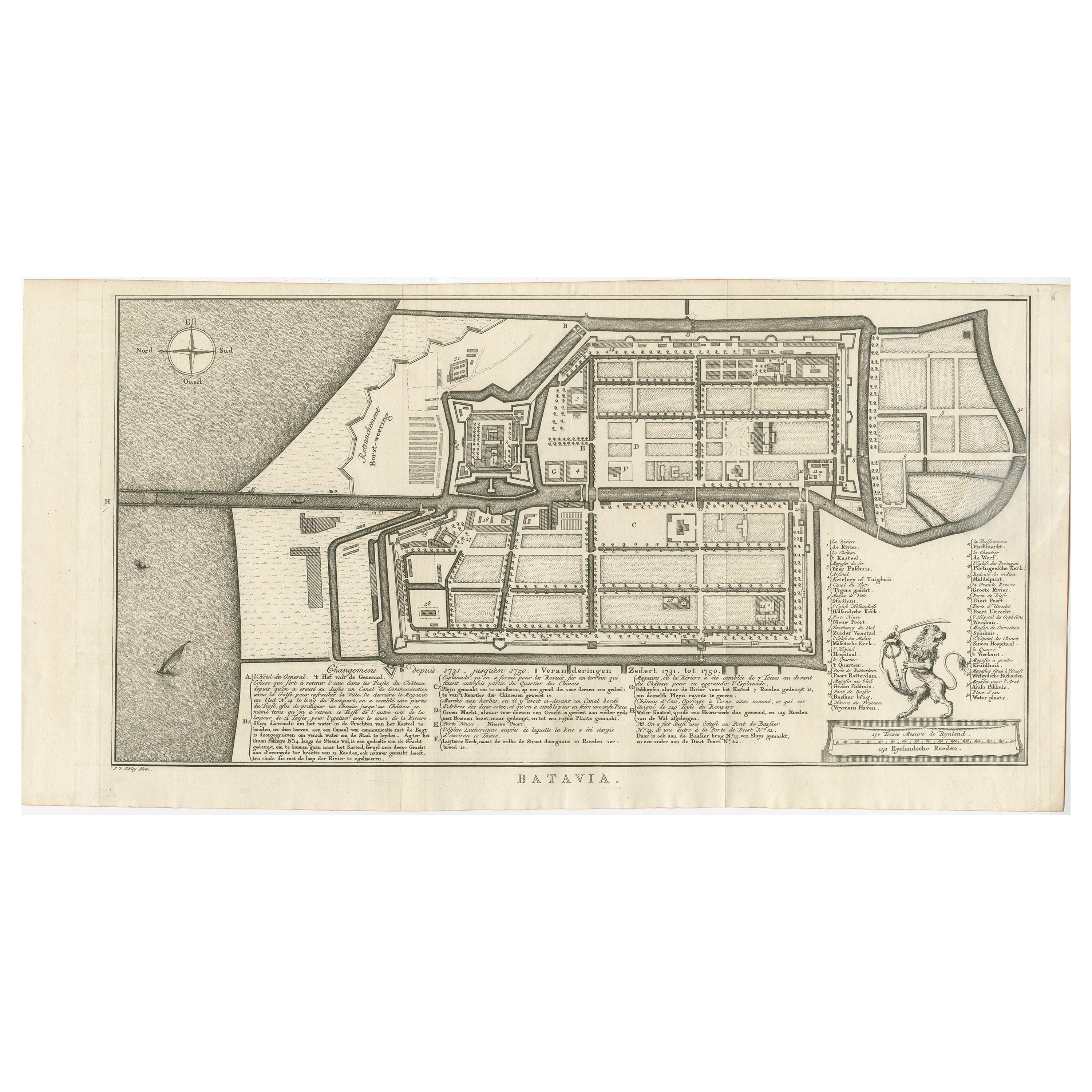
- Antique Map of Batavia by Van Schley 'c.1750'Located in Langweer, NLAntique map titled 'Batavia'. Original antique map of Batavia, Jakarta, Indonesia. This print originates from the Dutch edition of Prevost's 'Histoire Generale des Voyages' (Paris 17...Category
Antique Mid-18th Century Prints
MaterialsPaper
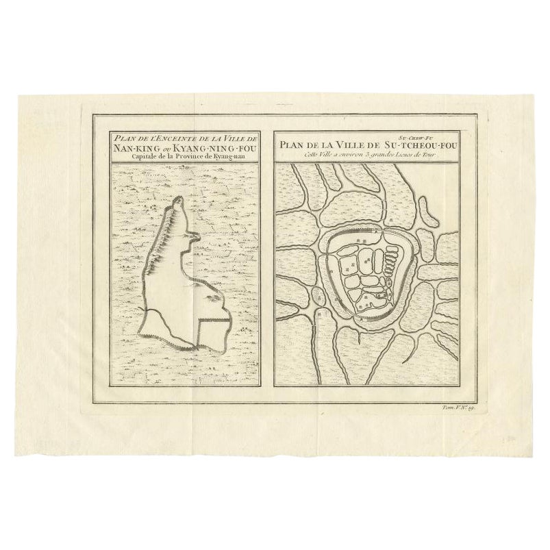
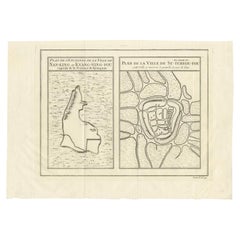
- Antique Map of Cities of the Jiangsu Region in China, c.1760By Jacques-Nicolas BellinLocated in Langweer, NLAntique map titled 'Plan de l' Enceinte de la Ville de Nan-King ou Kyang-Ning-Fou et plan de la ville de Su-Tcheou-Fou.' A map of the city of Nanking or Nanjing and a second map show...Category
Antique 18th Century Maps
MaterialsPaper
- Antique Map of Cities of the Province of Shanxi in China, 1749By Jacques-Nicolas BellinLocated in Langweer, NLAntique print titled: 'Lan-Tcheou ou Lan-Chew dan la province Chensi; Can Tcheou ou Kan-Chew dan la province de Chensi; Tchin-Ywe-Fou ou Chin-Ywen-Fu dans la province de Koei-Tcheou ...Category
Antique 18th Century Maps
MaterialsPaper
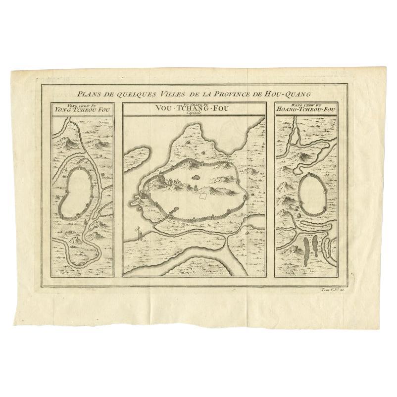
- Antique Map of Cities in the Hubei and Hunan Provinces of China, 1755By Jacques-Nicolas BellinLocated in Langweer, NLAntique print titled 'Plans de Quelques villes de la province de Hou-Quang.' Three bird's-eye view plans of walled cities in what are now China's Hubei (Hou-Quang) and Hunan Province...Category
Antique 18th Century Maps
MaterialsPaper
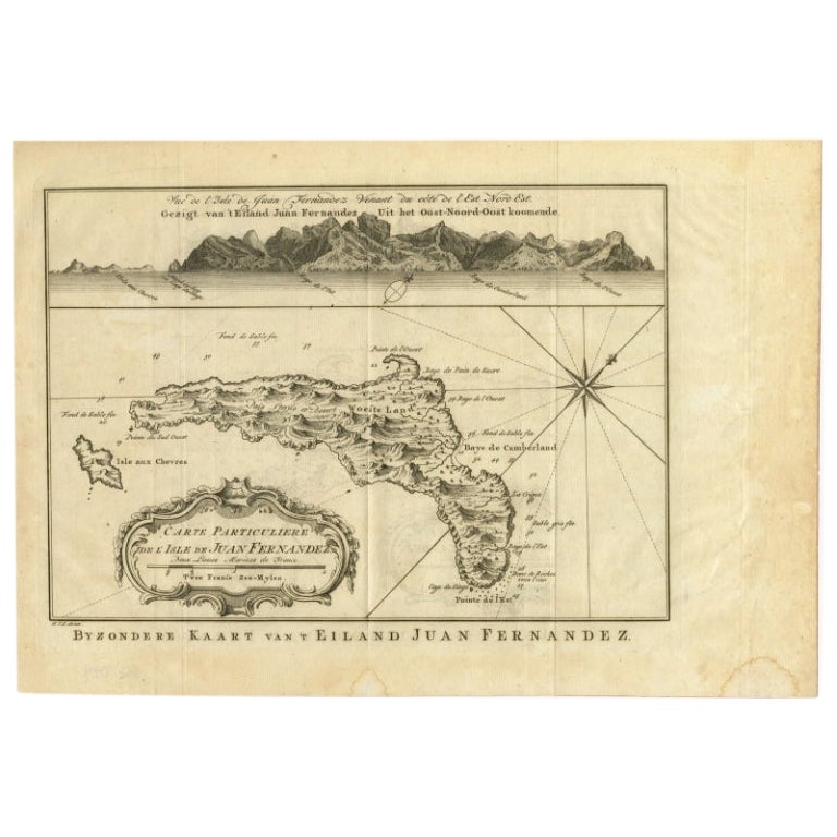
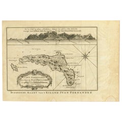
- Original Antique Map of Juan Fernandez by Van Schley, 1757Located in Langweer, NLAntique map titled 'Carte Particuliere de l'Isle de Juan Fernandez - Byzondere Kaart van 't Eiland Juan Fernandez'. Map of the Chilean Juan Fernandez Island, topped by a view of it...Category
Antique 18th Century Maps
MaterialsPaper
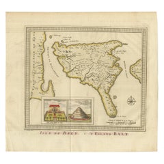
- Anbtique Map of the Island of Bali by Van Schley '1755'Located in Langweer, NLAntique map titled 'Isle de Baly - 't Eiland Baly'. Beautiful original antique map of Bali, Indonesia. Depicts the island from the north with Java to the l...Category
Antique Mid-18th Century Maps
MaterialsPaper


Recently Viewed
View AllMore Ways To Browse
Antique Bazaar
Wooden Painted Antique Cabinet
19th Century Dutch Cabinet
Ancient Greek Antiquities
Antique Art Deco Clock
Antique Chinese Box Painted
Antique Chinese Painted Box
Antique Church Pieces
Antique French Blue Box
Antique Size Bed Frame
Art Deco Antique Clocks
Art Deco Clock Antique Clocks
French Clock With Cherubs
Golden Brown Dress
Italian Antique Bed
Italian Beds Antique
Large Dressing Table
Letter Box Antique