Johannes Jansson Art
Dutch, 1729-1784
Jan Jansson or Johannes Janssonius (1588-1664) was born in Arnhem, Holland. His father was a printer and bookseller. In 1612 he married a Hondius daughter and became part of the prominent cartographic and publishing family business. He published his first map on his own in 1616. He partnered with his brother-in-law, the famous cartographer Henricus Hondius. They published their Atlas Major in eleven volumes. He also worked on newer editions of earlier Mercator/Hondius atlases. He published Jansson's English Country Maps in 1646. His brother-in-law continued the business following Jansson's death in 1664.
Abraham Goos (1590-1643) was a Dutch engraver of maps, sea charts, and globes, based initially in Antwerp and later in Amsterdam. The majority of his work was on maps created by Joannes Jansson, Jocodus Hondius, and John Speed.(Biography provided by Timeless Intaglio)
to
2
2
1
1
Overall Height
to
Overall Width
to
1
1
1
1
1
1
1
2
2
6,996
3,348
2,513
1,213
2
Artist: Johannes Jansson
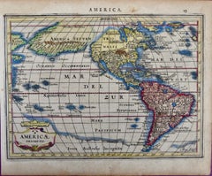
North & South America: A 17th Century Hand-colored Map by Jansson & Goos
By Johannes Jansson
Located in Alamo, CA
A 17th century hand-colored map of North & South America entitled "Americae Descriptio" by the cartographer Johannes Jansson, published in Jansson's Atlas Minor in Amsterdam in 1628....
Category
1620s Johannes Jansson Art
Materials
Engraving
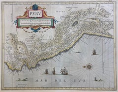
PERU
By Johannes Jansson
Located in Santa Monica, CA
JOHANNES JANSSON (1588 - 1664)
PERU, engraving with early coloring. Platemark 15 1/8 x 19 3/8 inches, sheet 17 x 20 1/2
A nice example of one of the earliest maps of Peru. From the ...
Category
1630s Old Masters Johannes Jansson Art
Materials
Engraving
Related Items
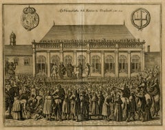
The Beheading of the King of England; Enthauptung des Königs in England
By Matthäus Merian the Elder
Located in Middletown, NY
The execution of Charles I (1600-1649) at Whitehall, January 30th 1649, in front of the Banqueting House. The executioner holding the head of Charles up to the crowd below.
Engravin...
Category
Mid-17th Century Old Masters Johannes Jansson Art
Materials
Engraving, Laid Paper
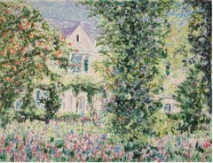
Series - Monet's House by Lélia Pissarro - Screenprint
By Lelia Pissarro
Located in London, GB
Series - Monet's House by Lélia Pissarro (B. 1963)
Serigraph
38 x 48 cm (15 x 18 ⁷/₈ inches)
Signed and numbered
Printed in an edition of 300
Artist's Biography:
Born in Paris in 19...
Category
21st Century and Contemporary Post-Impressionist Johannes Jansson Art
Materials
Screen
View of Pisaro, Italy: A 16th Century Hand-colored Map by Braun & Hogenberg
By Franz Hogenberg
Located in Alamo, CA
This is a 16th century original hand-colored copperplate engraved map of View of Pezaro (Pisaro), Italy entitled "Pisaurum vulgo Pezaro" by Georg Braun & Franz Hogenberg, from their famous city atlas "Civitates Orbis Terrarum", published in Augsberg, Germany in 1575.
The map depicts a view of Pesaro, Italy from the west looking over the town to the Adriatic Sea. The River Foglia flows into the Adriatic in the foreground. The only identifiable building is the cathedral of San Domenico, which rises above the other roofs with its tall spire. Two women, dressed in styles of the 16th century are in conversation on a hill in the foreground on the left. Pesaro is in the province of Pesaro and Urbino and lies on the Adriatic and east of Florence. The city, which was founded by the Etruscans and named Pisaurum by the Romans, belonged from AD 754 onwards to the Papal States, and after 1285 was controlled by the princely families of Malatesta, Sforza and della Rovere. Today it is the capital of the province of Pesaro and Urbino and has a population of about 92,000. Pesaro's most famous resident, composer Gioacchino Rossini, was born here in 1792.
The following is an English translation of an excerpt from Braun's description of the city: "We believe that the astonishingly short life of the inhabitants of Pesaro comes not only from the insalubrious air, but also from the great quantity of delectable and delicious fruits which they consume to excess. For this causes the production in their bodies of evil humours, which then lead to incurably fatal diseases. The area around the city is most charming and well planted with vineyards, fig trees, olive trees and other fruit-bearing trees."
References: Van der Krogt 4, 3369, state 1; Taschen, Braun and Hogenberg...
Category
16th Century Old Masters Johannes Jansson Art
Materials
Engraving
Lafitte's Blacksmith House (a bar named for a pirate on Bourbon St, New Orleans)
By Frederick Mershimer
Located in New Orleans, LA
Lafitte's Blacksmith Shop is a New Orleans landmark at 941 Bourbon St. Like most New Orleans legends, history of Lafitte's Blacksmith Shop is a gumbo of tru...
Category
Early 2000s Contemporary Johannes Jansson Art
Materials
Mezzotint, Aquatint
Asia Declineatio: A 17th Century Hand-colored Map of Asia by Justus Danckerts
Located in Alamo, CA
This is a scarce 17th century beautifully hand-colored copperplate engraved map of Asia entitled “Exactissima Asiae Delineatio in Praecipuas Regiones Caerterasque Partes divisa et de...
Category
Late 17th Century Old Masters Johannes Jansson Art
Materials
Engraving
St. Peter's Square in Basel: 17th Century Engraving by Matthäus Merian
By Matthäus Merian the Elder
Located in Alamo, CA
"Campus Divi Petri qui est Basileae" (St. Peter's Platz in Basel) is a 17th century engraving by the old master engraver Matthäus Merian the Elder...
Category
1650s Old Masters Johannes Jansson Art
Materials
Engraving
H 15.25 in W 19.94 in D 0.63 in
Cranes and Concrete (in the 80s, a boom saw buildings racing into the sky?
By Frederick Mershimer
Located in New Orleans, LA
"Cranes and Concrete" is Frederick Mershimer's mezzotint of the construction scene on Broadway between 13th and 14th streets. Mershimer is no strang...
Category
1980s Contemporary Johannes Jansson Art
Materials
Mezzotint
Map of the World: An Original 18th Century Hand-colored Map by E. Bowen
Located in Alamo, CA
This is an original 18th century hand-colored map entitled "A New & Correct Chart of All The Known World Laid down according to Mercator's Projection" by Emanuel Bowen. It was published in 1744 in London in John Harris's "Navigantium atque Itinerantium Bibliotheca" or "A Complete Collection of Voyages and Travels". This highly detailed and colorful map depicts the world. as it was known in the mid 18th century. A majority of the northern and central portions of Canada and America are left blank due to the purity of knowledge at the time this map was published.
The map is embellished with four Compass Roses in the lower left, lower center, lower right and center, along with many rhumb lines. There a is a decorative title cartouche in the upper left. This colorful, attractive, historical and interesting 1744 map presents the entire world on Mercator's projection as it was understood in the middle part of the 18th century, before the landmark explorations of Captain’s Cook, Vancouver, Wilkes and others. It is an example of a nautical chart, a type of map that was designed specifically for use by mariners. The map is centered on the equator and includes both the Eastern and Western Hemispheres. The continents of North America, South America, Europe, Africa, and Asia are depicted, as well as various islands in the Atlantic, Pacific, and Indian Oceans. The map is laid out according to the Mercator projection, a type of cylindrical map projection that was developed in the 16th century by Flemish cartographer Gerardus Mercator. This projection has the advantage of preserving angles and shapes, making it useful for navigation. The map presents a paucity of inland detail, particularly for the Americas, but major cities, geographical landmarks, and regions are included. Ocean currents and Tradewinds are identified, as well as the magnetic declination lines or magnetic variance, which refers to the difference between true north and compass north. The continents are color coded, enhancing the beauty of this map. The three compass roses indicate the directions of the cardinal points.
The depiction of the western coast of America, the Pacific and Australia are interesting. There was very little exploration of Australia between the navigations of William Damper in 1699 and Tobias Furneaux in 1773. Most of the maps detail relies on the 17th century Dutch expeditions to Australia's western coast, by Abel Tasman and William Janszoon. Van Diemen's Land (Tasmania) and New Guinea appear connected to the Australian continent. New Zealand appears as a single landmass. North of New Zealand there is a landmass labelled 'Ter d' St. Esprit' which probably represents the New Hebrides Islands. This map precedes the accurate exploration of the South Pacific and east coast of Australia by Captain James Cook later in the 18th century. The map includes ‘Drakes' Port,' the site where Sir Francis Drake supposedly landed in 1579 during his 1579 circumnavigation of the globe. Here he claimed territory for England, restocked, and repaired his vessels. Drake named the region New Albion. The exact location of Drake's Port is a cartographic mystery. Drake's Harbor is believed to be in the region of San Francisco Bay, Bodega Bay, San Pablo Bay...
Category
Mid-18th Century Old Masters Johannes Jansson Art
Materials
Engraving
Tournai (Tournay), Belgium: A 16th Century Hand-colored Map by Braun & Hogenberg
By Franz Hogenberg
Located in Alamo, CA
This is a 16th century original hand-colored copperplate engraved map of Tournai, Belgium, entitled "Tornacum" by Georg Braun & Franz Hogenberg, in volume IV of their famous city atlas "Civitates Orbis Terrarum", published in Cologne or Augsberg, Germany in 1575. The map provides a bird's-eye view of the walled city of Tournai, the second oldest city in Belgium. It lies approximately one hour by car southwest of Brussels or from Ghent. The names of thirty of its streets, prominent buildings, churches and squares are listed in a key within a strap-work cartouche in the lower left. These locations are numbered in the key corresponding to their locations on the map.
This colorful map of Tournai (Tornacum or Tournay as it was called in the 16th century) includes the title in Latin in a cartouche in the upper center. Three crests are present across the upper map. A man and two woman are standing on a hill in the foreground in the lower right dressed in the style of 16th century upper class residents of the town.
This is an English translation of an excerpt of Braun's description of Tornai: “Tornacum or Turnacum is a city in Gallia Belgica, situated on the Schelde in the territory of the Nervii, called Tournai by its French inhabitants, but Dorneck by the Germans. Tournai has always been a large and powerful city, with an abundance of goods and commercial activities and wonderfully resourceful craftsmen, who invent new articles every day, and although some of these go out of use they constantly conceive of other new things, both useful and delightful, so that they have at all times something that provides work and a means of livelihood for the poor."
ReferencesVan der Krogt 4, 4435, State 1; Taschen, Braun and Hogenberg...
Category
16th Century Old Masters Johannes Jansson Art
Materials
Engraving
Fountains of Rome
By Giovan Battista Falda
Located in Middletown, NY
A charming scene with romping dogs and spectators watching the cascading water play a trick on an unsuspecting man who is sprayed as he descends the steps, as the fountain was design...
Category
Early 17th Century Old Masters Johannes Jansson Art
Materials
Engraving, Etching, Laid Paper
L'automne, by Franz Edmond Weirotter, after van Goyen
By Jan Josefsz Van Goyen
Located in Middletown, NY
Etching and engraving on cream laid paper, 11 3/4 x 8 1/8 inches (297 x 205 mm), margins trimmed. Scattered light surface soiling, minor loose handling creases, rubbed edges, and sma...
Category
Mid-18th Century Old Masters Johannes Jansson Art
Materials
Etching, Handmade Paper, Laid Paper, Engraving
Foggy Night (the way home or a Stephen King setting)
By Carol Wax
Located in New Orleans, LA
This impression is #22
Carol Wax originally trained to be a classical musician at the Manhattan School of Music but fell in love with printmaking. Soon after she began engraving mez...
Category
2010s American Modern Johannes Jansson Art
Materials
Engraving, Mezzotint
Johannes Jansson art for sale on 1stDibs.
Find a wide variety of authentic Johannes Jansson art available for sale on 1stDibs. You can also browse by medium to find art by Johannes Jansson in engraving and more. Much of the original work by this artist or collective was created during the 18th century and earlier and is mostly associated with the Old Masters style. Not every interior allows for large Johannes Jansson art, so small editions measuring 9 inches across are available. Customers who are interested in this artist might also find the work of Gerard Mercator, Jacobus Houbraken, and Adriaen van Ostade. Johannes Jansson art prices can differ depending upon medium, time period and other attributes. On 1stDibs, the price for these items starts at $600 and tops out at $1,020, while the average work can sell for $810.


