Items Similar to Rare and Early Map of the Seventeen Provinces, Published in circa 1640


Want more images or videos?
Request additional images or videos from the seller
1 of 6
Rare and Early Map of the Seventeen Provinces, Published in circa 1640
About the Item
Antique map titled 'Carte Generale des Dixsept Provinces des Pais Bas'. Rare and Early map of the Seventeen Provinces. The Seventeen Provinces were the Imperial states of the Habsburg Netherlands in the 16th century. They roughly covered the Low Countries, i.e., what is now the Netherlands, Belgium, Luxembourg, and most of the French departments of Nord (French Flanders and French Hainaut) and Pas-de-Calais (Artois). Also within this area were semi-independent fiefdoms, mainly ecclesiastical ones, such as Liège, Cambrai and Stavelot-Malmedy. Map drawn by Melchior Tavernier. Engraved by A. de la Plaetsen. Published circa 1640.
- Dimensions:Height: 23.08 in (58.6 cm)Width: 16.93 in (43 cm)Depth: 0.02 in (0.5 mm)
- Materials and Techniques:
- Period:Mid-17th Century
- Date of Manufacture:circa 1640
- Condition:Original/contemporary hand coloring. Original folding line. Shows some wear and soling. Narrow margins, defect bottom left corner. Blank verso. Please study image carefully.
- Seller Location:Langweer, NL
- Reference Number:
About the Seller
5.0
Platinum Seller
These expertly vetted sellers are 1stDibs' most experienced sellers and are rated highest by our customers.
Established in 2009
1stDibs seller since 2017
1,974 sales on 1stDibs
Typical response time: <1 hour
- ShippingRetrieving quote...Ships From: Langweer, Netherlands
- Return PolicyA return for this item may be initiated within 14 days of delivery.
More From This SellerView All
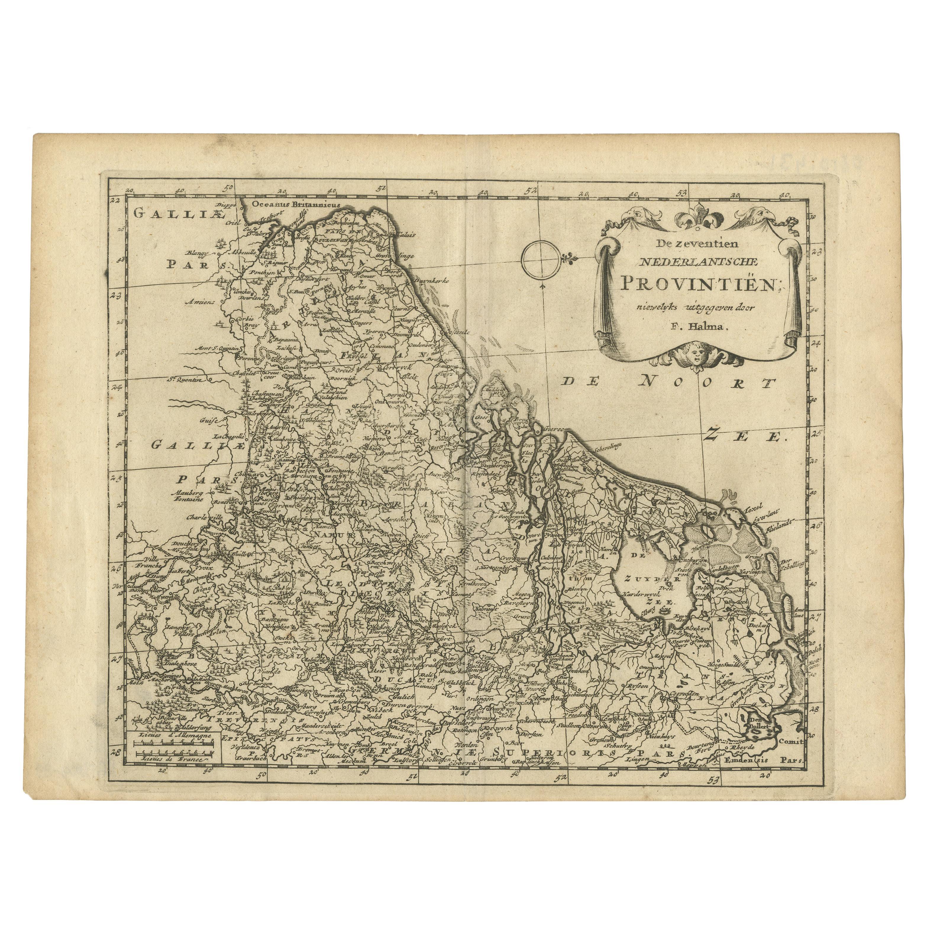
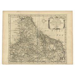
- Antique Map of the Seventeen Provinces by Halma '1705'Located in Langweer, NLAntique map titled 'De zeventien Nederlantsche Provintiën'. Original antique map of the Seventeen Provinces, the Imperial states of the Habsburg Netherlands in the 16th century. This...Category
Antique Early 18th Century Maps
MaterialsPaper
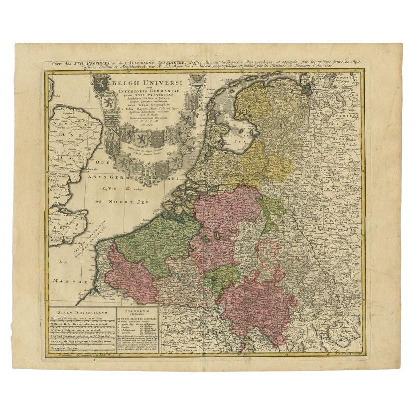
- Antique Map of the Seventeen Provinces by Homann Heirs, 1748By Homann HeirsLocated in Langweer, NLAntique map titled 'Belgii Universi seu Inferioris Germaniae quam XVII Provinciae (..)'. Map of the Seventeen Provinces after Tobias Meier, published by Homann's Heirs in 1748. The S...Category
Antique 18th Century Maps
MaterialsPaper
- Antique Map of the Seventeen Provinces of Netherlands, Belgium, Luxembourg, 1748By Homann HeirsLocated in Langweer, NLAntique map titled 'Belgii Universi seu Inferioris Germaniae quam XVII Provinciae (..)'. Map of the Seventeen Provinces after Tobias Meier, published by Homann's Heirs in 1748. The...Category
Antique 18th Century Maps
MaterialsPaper
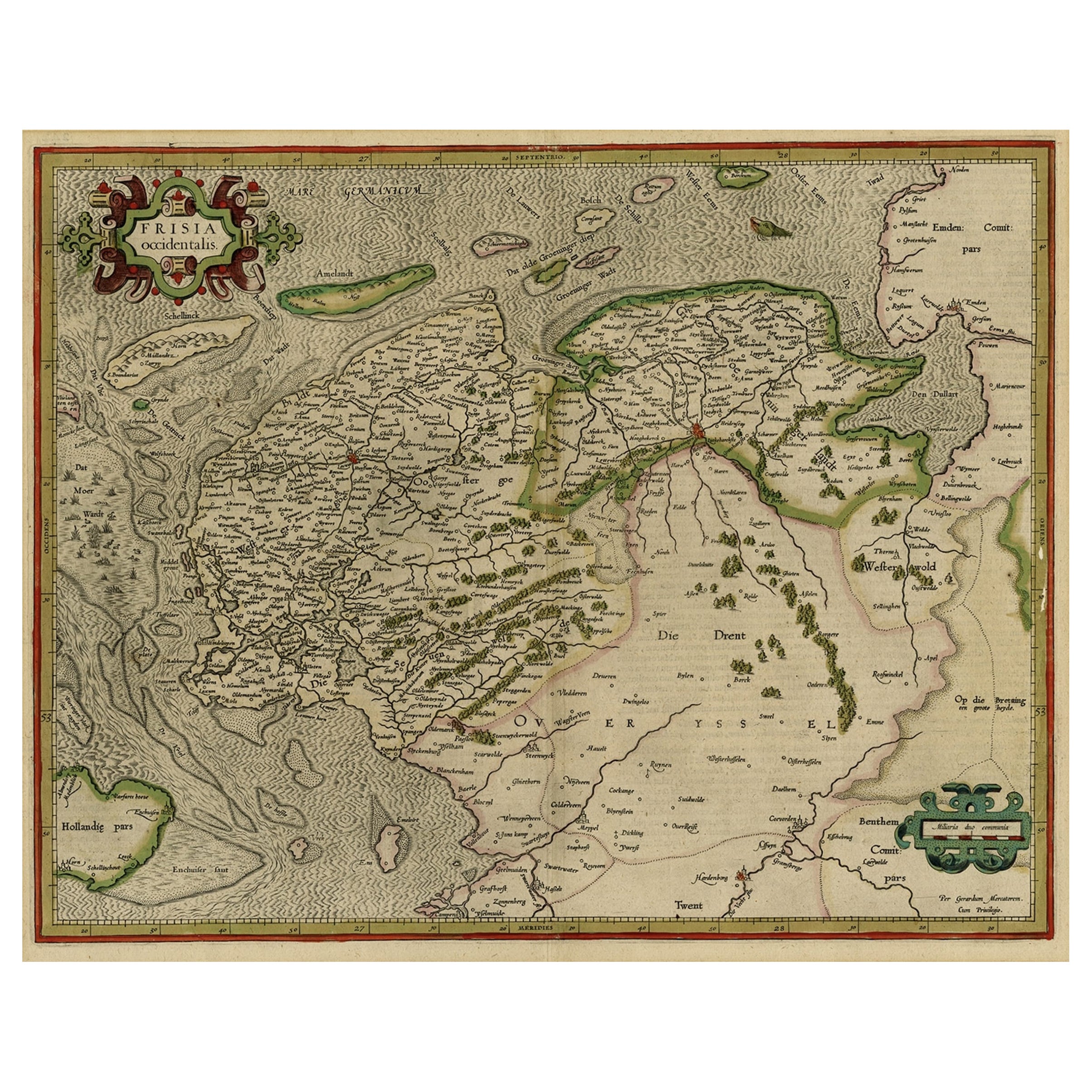
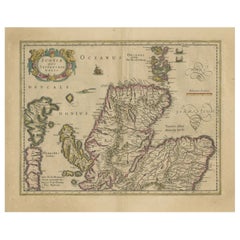
- Early Antique Map of the Dutch Provinces of Friesland and Groningen, 1604Located in Langweer, NLAntique map titled 'Frisiae Occidentalis.' This attractive map shows the Dutch Provinces of Friesland and Groningen. Embellished with strapwork tit...Category
Antique Early 1600s Maps
MaterialsPaper
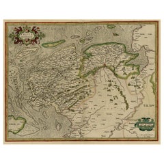
- Antique Map of the Hainaut and Namur Region by Janssonius, 'circa 1640'By Johannes JanssoniusLocated in Langweer, NLAntique map titled 'Comitatuum Hannoniae et Namurci Descriptio'. Old map of the region of Hainaut and Namur, France. Published by J. Janssonius, circa 1640.Category
Antique Mid-17th Century Maps
MaterialsPaper
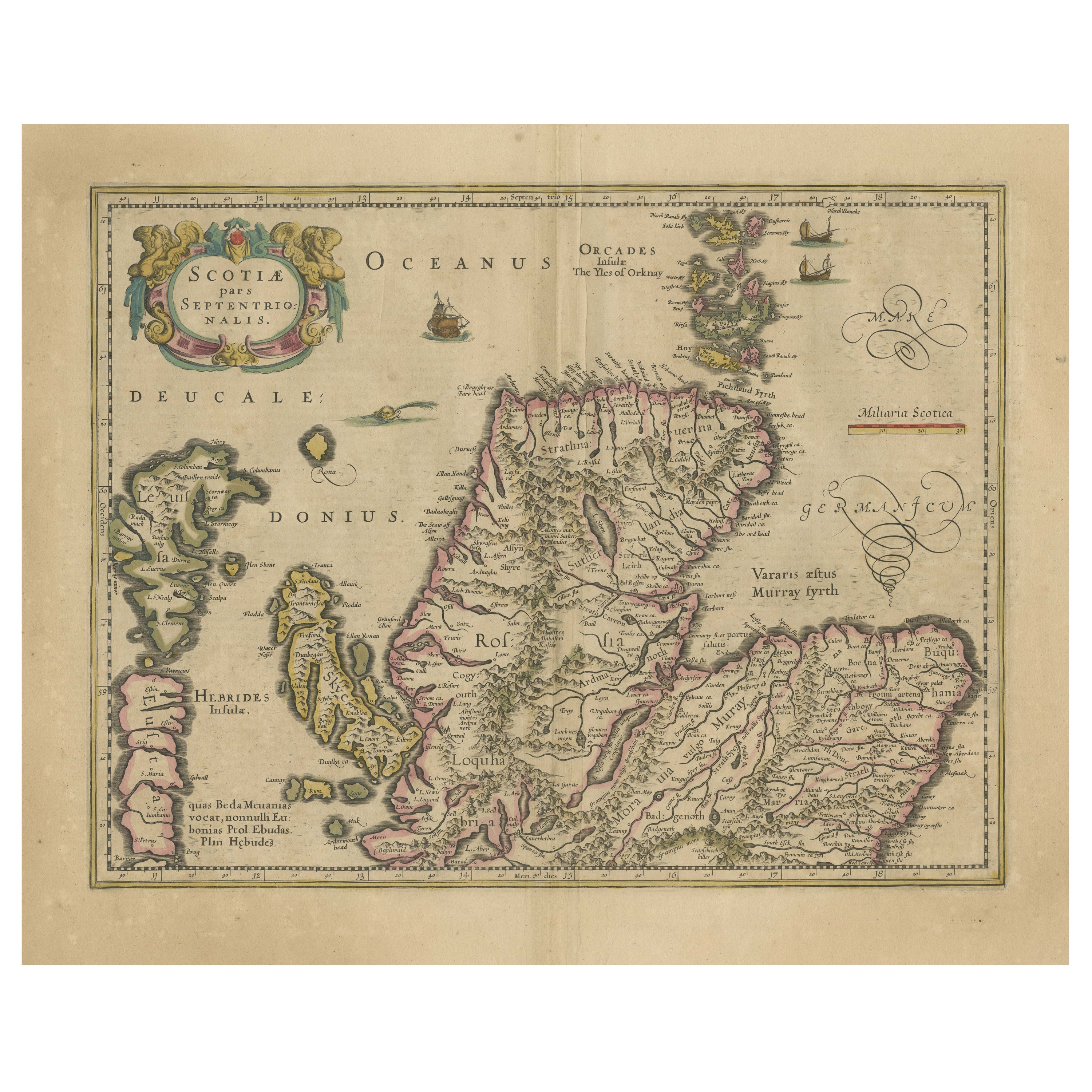
- Original Antique Map of the Northern Part of Scotland, circa 1640Located in Langweer, NLThe antique map, titled 'Scotiae pars septentrionalis,' depicts the northern part of Scotland. Crafted by Hondius around 1640, this map is a historical treasure showcasing the geogra...Category
Antique Mid-17th Century Maps
MaterialsPaper


You May Also Like
- Map of the Republic of GenoaLocated in New York, NYFramed antique hand-coloured map of the Republic of Genoa including the duchies of Mantua, Modena, and Parma. Europe, late 18th century. Dimension: 25...Category
Antique Late 18th Century European Maps
- Map "Estuary- Mouth of the Thames"Located in Alessandria, PiemonteST/426 - Antique French Map of the estuary of the Thames, map dated 1769 - "Mape of the entrance of the Thames. Designed by filing of Navy cards fo...Category
Antique Mid-18th Century French Other Prints
MaterialsPaper
- Original Antique Map of South America, circa 1830Located in St Annes, LancashireGreat map of South America Copper plate engraving Published by Butterworth, Livesey & Co., circa 1830 Unframed.Category
Antique Early 1800s English Other Maps
MaterialsPaper

- Hand-Colored 18th Century Homann Map of Denmark and Islands in the Baltic SeaBy Johann Baptist HomannLocated in Alamo, CAAn 18th century copper plate hand-colored map entitled "Insulae Danicae in Mari Balthico Sitae utpote Zeelandia, Fionia, Langelandia, Lalandia, Falstria, Fembria Mona" created by Joh...Category
Antique Early 18th Century German Maps
MaterialsPaper
- Original Antique Map of Belgium by Tallis, Circa 1850Located in St Annes, LancashireGreat map of Belgium Steel engraving Many lovely vignettes Published by London Printing & Publishing Co. ( Formerly Tallis ), C.1850 Origin...Category
Antique 1850s English Maps
MaterialsPaper
- Vintage "View of the Center of Paris Taken from the Air" Lithograph MapLocated in San Diego, CAA very stylish "View of the Center of Paris Taken from the Air" lithograph map published by the Paris Ministry of Tourism, circa early 1950s. The piece measures 27" x 43" and shows...Category
20th Century French Mid-Century Modern Prints
MaterialsPaper


Recently Viewed
View AllMore Ways To Browse
Oceanic Wood Carving
Wood Carving Ocean
Afghanistan Map
Antique Map Of Boston
Antique Map Of Turkish Empire
Antique Maps Of Ancient Greece
Antique Maps Of Boston
Antique Texas Map
Antique Texas Maps
Ipswich Antique Furniture
Sardinia Map
Antique Compass Made In France
Antique Map Of Ohio
Antique Maps Of Texas
Antique Maps Of Venice Italy
Mississippi Map
Used Office Furniture Cornwall
Yorkshire Map